TopoQuest Logo
Do you find TopoQuest useful?
Help keep TopoQuest running and adding new maps/features by donating!
Bitcoin:  19c7KJd3qBynnjoSw5npx9KScwjBe4ifkT
Litecoin:  LXs6TkuXGGXo1vDsWCkWVdjQX94eUKd6ui
Home View Maps Find Maps Find Places Resources & Links


Naubinway, Michigan Topographic Map

USGS Map Title: Naubinway, MI
USGS Map MRC: 46085A4
DRG (GeoTIFF) Download: o46085a4.tif


Neighboring USGS Topographic Map Quads:


  Millecoquins, MI  
46085B5
 

  Gilchrist, MI  
46085B4
 

  Garnet, MI  
46085B3
 

  Engadine, MI  
46085A5
 

  Naubinway, MI  
46085A4
 

  Hog Island Point, MI  
46085A3


Map MRC Location:

N47°
W86°
N47°
W85°
H8 H7 H6 H5 H4 H3 H2 H1
G8 G7 G6 G5 G4 G3 G2 G1
F8 F7 F6 F5 F4 F3 F2 F1
E8 E7 E6 E5 E4 E3 E2 E1
D8 D7 D6 D5 D4 D3 D2 D1
C8 C7 C6 C5 C4 C3 C2 C1
B8 B7 B6 B5 B4 B3 B2 B1
A8 A7 A6 A5 A4 A3 A2 A1
N46°
W86°
N46°
W85°

Naubinway, MI USGS 1:24K Topographic Map Preview:
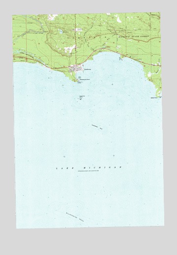
Naubinway, MI USGS Topographic Map
Click on map above to begin viewing in our Map Viewer.

This topographic map contains these locations and features:
Feature Name Type Latitude Longitude GNIS ID View Map
Biddle PointCapeN46.0756°W85.3779°621278View Map
East Mile CreekStreamN46.1019°W85.4273°625232View Map
Elbow LakeLakeN46.1145°W85.4591°625428View Map
Garfield Township Fire Department Station 2BuildingN46.0930°W85.4479°2626820View Map
Hiawatha Golf ClubLocaleN46.1050°W85.4514°2359902View Map
Lower Millecoquins RiverStreamN46.0961°W85.4804°631179View Map
Mackinac Straits Medical ClinicHospitalN46.1003°W85.4356°2359904View Map
Mattix CreekStreamN46.0889°W85.3895°631742View Map
Michigan Department of Natural Resources Naubinway Field OfficeBuildingN46.0947°W85.4448°2627073View Map
Millecoquins PointCapeN46.0861°W85.4487°632355View Map
Millecoquins ReefsBarN46.0083°W85.4501°632357View Map
NaubinwayPopulated PlaceN46.0925°W85.4476°633234View Map
Naubinway CemeteryCemeteryN46.1014°W85.4531°633235View Map
Naubinway Christian FellowshipChurchN46.0931°W85.4475°2359903View Map
Naubinway IslandIslandN46.0756°W85.4454°633236View Map
Naubinway Island LightLocaleN46.0758°W85.4448°1623076View Map
Naubinway Post OfficePost OfficeN46.0941°W85.4483°2359907View Map
Naubinway ReefBarN46.0583°W85.4290°633237View Map
Naubinway Rest AreaLocaleN46.0972°W85.3975°2359901View Map
Northernmost Point of Lake Michigan Historical MarkerParkN46.0975°W85.3972°2360040View Map
Threemile CreekStreamN46.1222°W85.4801°1614830View Map
West Mile CreekStreamN46.1025°W85.4279°1616150View Map

Note: Coordinates in the location and feature list above are referenced to NAD83 datum.


Copyright (C) 2008-2024 Ryan Niemi / Sunset Dynamics ... All Rights Reserved