TopoQuest Logo
Do you find TopoQuest useful?
Help keep TopoQuest running and adding new maps/features by donating!
Bitcoin:  19c7KJd3qBynnjoSw5npx9KScwjBe4ifkT
Litecoin:  LXs6TkuXGGXo1vDsWCkWVdjQX94eUKd6ui
Home View Maps Find Maps Find Places Resources & Links


Navasota, Texas Topographic Map

USGS Map Title: Navasota, TX
USGS Map MRC: 30096D1
DRG (GeoTIFF) Download: o30096d1.tif


Neighboring USGS Topographic Map Quads:


  Ferguson Crossing, TX  
30096E2
 

  Carlos, TX  
30096E1
 

  Roans Prairie, TX  
30095E8
 

  Millican, TX  
30096D2
 

  Navasota, TX  
30096D1
 

  Anderson, TX  
30095D8
 

  Washington, TX  
30096C2
 

  Courtney, TX  
30096C1
 

  Stoneham, TX  
30095C8


Map MRC Location:

N31°
W97°
N31°
W96°
H8 H7 H6 H5 H4 H3 H2 H1
G8 G7 G6 G5 G4 G3 G2 G1
F8 F7 F6 F5 F4 F3 F2 F1
E8 E7 E6 E5 E4 E3 E2 E1
D8 D7 D6 D5 D4 D3 D2 D1
C8 C7 C6 C5 C4 C3 C2 C1
B8 B7 B6 B5 B4 B3 B2 B1
A8 A7 A6 A5 A4 A3 A2 A1
N30°
W97°
N30°
W96°

Navasota, TX USGS 1:24K Topographic Map Preview:
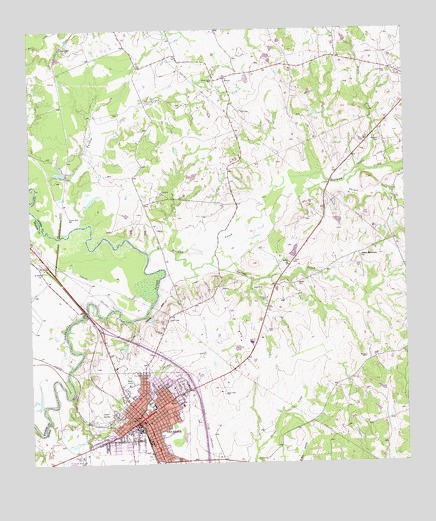
Navasota, TX USGS Topographic Map
Click on map above to begin viewing in our Map Viewer.

This topographic map contains these locations and features:
Feature Name Type Latitude Longitude GNIS ID View Map
Berryman CemeteryCemeteryN30.4680°W96.0077°1372506View Map
Bridle Ridge AirportAirportN30.4180°W96.0794°1387239View Map
Cedar CreekStreamN30.3944°W96.1122°1354049View Map
City of NavasotaCivilN30.3870°W96.0895°2411217View Map
ErwinPopulated PlaceN30.4860°W96.0600°1379733View Map
Erwin CemeteryCemeteryN30.4766°W96.0544°1357053View Map
Foster HouseBuildingN30.4094°W96.0502°2031190View Map
Grimes County Constable's Office Precinct 3BuildingN30.3933°W96.0777°2739242View Map
Grimes Saint Joseph Health CenterHospitalN30.3927°W96.0775°2718991View Map
Holland CreekStreamN30.4355°W96.0855°1359409View Map
Honey CreekStreamN30.4605°W96.0144°1359492View Map
John C Webb Elementary SchoolSchoolN30.4008°W96.0780°2005476View Map
KNAV-FM (Navasota)TowerN30.4163°W96.0788°1388042View Map
KWBC-AM (Navasota)TowerN30.3802°W96.1005°1387869View Map
NavasotaPopulated PlaceN30.3880°W96.0877°1375099View Map
Navasota City HallBuildingN30.3872°W96.0879°2753311View Map
Navasota Commercial Historic DistrictLocaleN30.3874°W96.0927°2031952View Map
Navasota Intermediate SchoolSchoolN30.3922°W96.0844°2005478View Map
Navasota Police DepartmentBuildingN30.3871°W96.0877°2739198View Map
Navasota Post OfficePost OfficeN30.3876°W96.0884°2731803View Map
Navasota Primary SchoolSchoolN30.3985°W96.0791°2005480View Map
Navasota Regional Hospital HeliportAirportN30.3924°W96.0775°1387238View Map
Navasota Volunteer Fire DepartmentBuildingN30.3762°W96.0821°2552212View Map
Neblett CemeteryCemeteryN30.4269°W96.0363°1363625View Map
Oakland CemeteryCemeteryN30.3905°W96.1008°1364303View Map
P A Smith HotelBuildingN30.3877°W96.0886°2031747View Map
Prescott LakeReservoirN30.4325°W96.0421°1864921View Map
Prescott Lake DamDamN30.4335°W96.0402°1864920View Map
Saint John ChurchChurchN30.4305°W96.1211°1367169View Map
Salem CemeteryCemeteryN30.4324°W96.0169°1367348View Map
Salem ChurchChurchN30.4327°W96.0388°1367353View Map
Salem Missionary ChurchChurchN30.4344°W96.0147°1367360View Map
Spring CreekStreamN30.4327°W96.0647°1368970View Map
Steele Grove CemeteryCemeteryN30.4855°W96.0633°1369148View Map
Steele HouseBuildingN30.3894°W96.0836°2032587View Map
Thomas CreekStreamN30.4555°W96.0252°1369838View Map
Turkey CreekStreamN30.4444°W96.1055°1370221View Map

Note: Coordinates in the location and feature list above are referenced to NAD83 datum.


Copyright (C) 2008-2024 Ryan Niemi / Sunset Dynamics ... All Rights Reserved