TopoQuest Logo
Do you find TopoQuest useful?
Help keep TopoQuest running and adding new maps/features by donating!
Bitcoin:  19c7KJd3qBynnjoSw5npx9KScwjBe4ifkT
Litecoin:  LXs6TkuXGGXo1vDsWCkWVdjQX94eUKd6ui
Home View Maps Find Maps Find Places Resources & Links


Roans Prairie, Texas Topographic Map

USGS Map Title: Roans Prairie, TX
USGS Map MRC: 30095E8
DRG (GeoTIFF) Download: o30095e8.tif


Neighboring USGS Topographic Map Quads:


  Keith, TX  
30096F1
 

  Singleton, TX  
30095F8
 

  Loma, TX  
30095F7
 

  Carlos, TX  
30096E1
 

  Roans Prairie, TX  
30095E8
 

  Richards, TX  
30095E7
 

  Navasota, TX  
30096D1
 

  Anderson, TX  
30095D8
 

  Dacus, TX  
30095D7


Map MRC Location:

N31°
W96°
N31°
W95°
H8 H7 H6 H5 H4 H3 H2 H1
G8 G7 G6 G5 G4 G3 G2 G1
F8 F7 F6 F5 F4 F3 F2 F1
E8 E7 E6 E5 E4 E3 E2 E1
D8 D7 D6 D5 D4 D3 D2 D1
C8 C7 C6 C5 C4 C3 C2 C1
B8 B7 B6 B5 B4 B3 B2 B1
A8 A7 A6 A5 A4 A3 A2 A1
N30°
W96°
N30°
W95°

Roans Prairie, TX USGS 1:24K Topographic Map Preview:
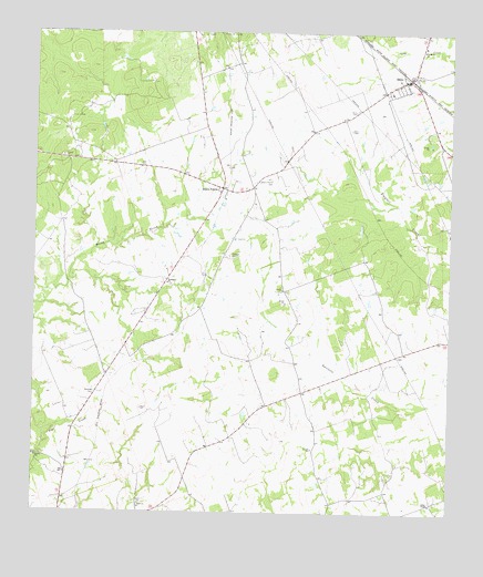
Roans Prairie, TX USGS Topographic Map
Click on map above to begin viewing in our Map Viewer.

This topographic map contains these locations and features:
Feature Name Type Latitude Longitude GNIS ID View Map
Arbor ChapelChurchN30.5027°W95.8805°1351232View Map
Bethlehem ChurchChurchN30.5596°W95.9600°1351970View Map
Gibbons SpringSpringN30.6085°W95.9919°1998564View Map
Grimes CountyCivilN30.5435°W95.9855°1383878View Map
Hideaway Hills Lake DamDamN30.5052°W95.9686°1860285View Map
Hideaway LakeReservoirN30.5076°W95.9711°1860286View Map
KYLE-TV (Bryan)TowerN30.5663°W95.9902°1386071View Map
Oakland CemeteryCemeteryN30.5669°W95.9413°1364304View Map
Roans PrairiePopulated PlaceN30.5844°W95.9438°1366554View Map
Roans Prairie CemeteryCemeteryN30.5866°W95.9288°1366555View Map
Saint Marks ChurchChurchN30.6208°W95.8838°1367242View Map
ShiroPopulated PlaceN30.6133°W95.8883°1368209View Map
Shiro CemeteryCemeteryN30.6052°W95.9038°1368210View Map
Shiro Post OfficePost OfficeN30.6129°W95.8899°2732198View Map
Shiro Volunteer Fire DepartmentBuildingN30.6112°W95.8918°2552583View Map

Note: Coordinates in the location and feature list above are referenced to NAD83 datum.


Copyright (C) 2008-2025 Ryan Niemi / Sunset Dynamics ... All Rights Reserved