TopoQuest Logo
Do you find TopoQuest useful?
Help keep TopoQuest running and adding new maps/features by donating!
Bitcoin:  19c7KJd3qBynnjoSw5npx9KScwjBe4ifkT
Litecoin:  LXs6TkuXGGXo1vDsWCkWVdjQX94eUKd6ui
Home View Maps Find Maps Find Places Resources & Links


Necedah, Wisconsin Topographic Map

USGS Map Title: Necedah, WI
USGS Map MRC: 44090A1
DRG (GeoTIFF) Download: o44090a1.tif


Neighboring USGS Topographic Map Quads:


  Finley, WI  
44090B2
 

  New Miner, WI  
44090B1
 

  Arkdale NW, WI  
44089B8
 

  Cutler, WI  
44090A2
 

  Necedah, WI  
44090A1
 

  Arkdale, WI  
44089A8
 

  New Lisbon North, WI  
43090H2
 

  Kelly, WI  
43090H1
 

  Dellwood, WI  
43089H8


Map MRC Location:

N45°
W91°
N45°
W90°
H8 H7 H6 H5 H4 H3 H2 H1
G8 G7 G6 G5 G4 G3 G2 G1
F8 F7 F6 F5 F4 F3 F2 F1
E8 E7 E6 E5 E4 E3 E2 E1
D8 D7 D6 D5 D4 D3 D2 D1
C8 C7 C6 C5 C4 C3 C2 C1
B8 B7 B6 B5 B4 B3 B2 B1
A8 A7 A6 A5 A4 A3 A2 A1
N44°
W91°
N44°
W90°

Necedah, WI USGS 1:24K Topographic Map Preview:
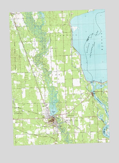
Necedah, WI USGS Topographic Map
Click on map above to begin viewing in our Map Viewer.

This topographic map contains these locations and features:
Feature Name Type Latitude Longitude GNIS ID View Map
Bayview CemeteryCemeteryN44.0294°W90.0771°1834283View Map
Fish LakeBayN44.0208°W90.0082°1564993View Map
Juneau County Charter SchoolSchoolN44.0421°W90.0359°1572488View Map
NecedahPopulated PlaceN44.0261°W90.0740°1570130View Map
Necedah AirportAirportN44.0339°W90.0836°1582099View Map
Necedah BluffSummitN44.0222°W90.0746°1570131View Map
Necedah DamDamN44.0257°W90.0713°1791944View Map
Necedah Elementary SchoolSchoolN44.0004°W90.0740°2715723View Map
Necedah Fire DepartmentBuildingN44.0254°W90.0742°2698076View Map
Necedah Flowage 491ReservoirN44.0266°W90.0701°1791945View Map
Necedah LakeReservoirN44.0337°W90.0715°1570132View Map
Necedah Middle / High SchoolSchoolN44.0003°W90.0740°1834749View Map
Necedah Oak-Pine Forest State Natural AreaParkN44.0730°W90.1151°2057360View Map
Necedah Police DepartmentBuildingN44.0256°W90.0730°2759585View Map
Necedah Wastewater Treatment FacilityLocaleN44.0174°W90.0647°2729075View Map
Petenwell 2WP722 DamDamN44.0566°W90.0201°1792955View Map
Petenwell DamDamN44.0574°W90.0207°1571253View Map
Petenwell Flowage 5879ReservoirN44.0566°W90.0201°1792956View Map
Petenwell RockSummitN44.0458°W90.0204°1571255View Map
Queen of the Holy Rosary SchoolSchoolN44.0228°W90.0512°2715648View Map
Queen of the Holy Rosary ShrineChurchN44.0211°W90.0562°1571997View Map
Town of NecedahCivilN44.0525°W90.1124°1583783View Map
Village of NecedahCivilN44.0232°W90.0718°1583782View Map
West Petenwell DitchCanalN44.0883°W90.0449°1576542View Map

Note: Coordinates in the location and feature list above are referenced to NAD83 datum.


Copyright (C) 2008-2024 Ryan Niemi / Sunset Dynamics ... All Rights Reserved