TopoQuest Logo
Do you find TopoQuest useful?
Help keep TopoQuest running and adding new maps/features by donating!
Bitcoin:  19c7KJd3qBynnjoSw5npx9KScwjBe4ifkT
Litecoin:  LXs6TkuXGGXo1vDsWCkWVdjQX94eUKd6ui
Home View Maps Find Maps Find Places Resources & Links


Dellwood, Wisconsin Topographic Map

USGS Map Title: Dellwood, WI
USGS Map MRC: 43089H8
DRG (GeoTIFF) Download: o43089h8.tif


Neighboring USGS Topographic Map Quads:


  Necedah, WI  
44090A1
 

  Arkdale, WI  
44089A8
 

  Roche A Cri, WI  
44089A7
 

  Kelly, WI  
43090H1
 

  Dellwood, WI  
43089H8
 

  Adams, WI  
43089H7
 

  Mauston, WI  
43090G1
 

  Round Bluff, WI  
43089G8
 

  Easton, WI  
43089G7


Map MRC Location:

N44°
W90°
N44°
W89°
H8 H7 H6 H5 H4 H3 H2 H1
G8 G7 G6 G5 G4 G3 G2 G1
F8 F7 F6 F5 F4 F3 F2 F1
E8 E7 E6 E5 E4 E3 E2 E1
D8 D7 D6 D5 D4 D3 D2 D1
C8 C7 C6 C5 C4 C3 C2 C1
B8 B7 B6 B5 B4 B3 B2 B1
A8 A7 A6 A5 A4 A3 A2 A1
N43°
W90°
N43°
W89°

Dellwood, WI USGS 1:24K Topographic Map Preview:
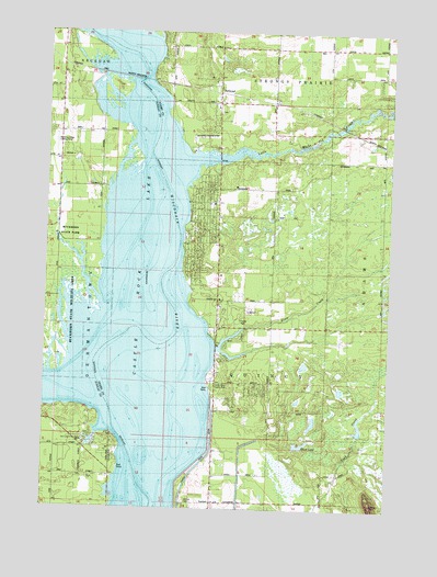
Dellwood, WI USGS Topographic Map
Click on map above to begin viewing in our Map Viewer.

This topographic map contains these locations and features:
Feature Name Type Latitude Longitude GNIS ID View Map
17 ReservoirReservoirN43.8953°W89.8860°1793193View Map
Accurate AirportAirportN43.9711°W89.9971°1834348View Map
Buckhorn Barrens State Natural AreaParkN43.9277°W89.9993°2057357View Map
Buckhorn State ParkParkN43.9416°W89.9993°1834287View Map
Buckhorn State Wildlife AreaParkN43.9214°W89.9960°1834288View Map
Castle Rock County ParkParkN43.8883°W89.9757°1834291View Map
Castle Rock County ParkParkN43.9083°W89.9396°1837576View Map
Castle Rock DitchCanalN43.8925°W89.9393°1562793View Map
Castle Rock LakeReservoirN43.9320°W89.9788°1577900View Map
Dellaire Landing Strip (historical)AirportN43.9725°W89.9426°1837583View Map
DellwoodPopulated PlaceN43.9841°W89.9387°1563891View Map
Dellwood CemeteryCemeteryN43.9788°W89.9385°1563892View Map
Dellwood Census Designated PlaceCensusN43.9545°W89.9341°2586473View Map
Klein CreekStreamN43.9169°W89.9379°1567545View Map
Little Roche a Cri CreekStreamN43.9655°W89.9473°1568387View Map
Murmuring Springs AirportAirportN43.9974°W89.9994°2444170View Map
Our Lady of the Lake Catholic ChurchChurchN43.8922°W89.9860°1834325View Map
Quincy (historical)Populated PlaceN43.8764°W89.9562°1837599View Map
Quincy CemeteryCemeteryN43.8769°W89.9485°1572004View Map
Quincy Volunteer Fire DepartmentBuildingN43.8767°W89.9389°2697879View Map
Quincy Volunteer Fire Department Station 1BuildingN43.9628°W89.9382°2697498View Map
Schwahn 3NC78806 DamDamN43.8950°W89.8835°1793192View Map
Silver LakeLakeN43.8914°W89.9059°1574132View Map
Sohlberg Silver Lake State Natural AreaParkN43.8916°W89.9051°2054278View Map
Town of QuincyCivilN43.8910°W89.9134°1583990View Map
Yellow RiverStreamN43.9064°W89.9832°1577088View Map

Note: Coordinates in the location and feature list above are referenced to NAD83 datum.


Copyright (C) 2008-2024 Ryan Niemi / Sunset Dynamics ... All Rights Reserved