TopoQuest Logo
Do you find TopoQuest useful?
Help keep TopoQuest running and adding new maps/features by donating!
Bitcoin:  19c7KJd3qBynnjoSw5npx9KScwjBe4ifkT
Litecoin:  LXs6TkuXGGXo1vDsWCkWVdjQX94eUKd6ui
Home View Maps Find Maps Find Places Resources & Links


Nectar, Alabama Topographic Map

USGS Map Title: Nectar, AL
USGS Map MRC: 33086H6
DRG (GeoTIFF) Download: o33086h6.tif


Neighboring USGS Topographic Map Quads:


  Hanceville, AL  
34086A7
 

  Garden City, AL  
34086A6
 

  Blountsville, AL  
34086A5
 

  Blount Springs, AL  
33086H7
 

  Nectar, AL  
33086H6
 

  Cleveland, AL  
33086H5
 

  Warrior, AL  
33086G7
 

  Trafford, AL  
33086G6
 

  Remlap, AL  
33086G5


Map MRC Location:

N34°
W87°
N34°
W86°
H8 H7 H6 H5 H4 H3 H2 H1
G8 G7 G6 G5 G4 G3 G2 G1
F8 F7 F6 F5 F4 F3 F2 F1
E8 E7 E6 E5 E4 E3 E2 E1
D8 D7 D6 D5 D4 D3 D2 D1
C8 C7 C6 C5 C4 C3 C2 C1
B8 B7 B6 B5 B4 B3 B2 B1
A8 A7 A6 A5 A4 A3 A2 A1
N33°
W87°
N33°
W86°

Nectar, AL USGS 1:24K Topographic Map Preview:
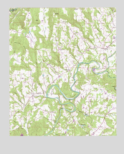
Nectar, AL USGS Topographic Map
Click on map above to begin viewing in our Map Viewer.

This topographic map contains these locations and features:
Feature Name Type Latitude Longitude GNIS ID View Map
AdvillePopulated PlaceN33.8840°W86.6447°112938View Map
Ann Johnson MountainSummitN33.9962°W86.7211°113087View Map
Center Springs ChurchChurchN33.8765°W86.6567°163850View Map
Congregational Methodist ChurchChurchN33.9615°W86.6333°135090View Map
Copeland FordCrossingN33.8890°W86.6908°163167View Map
Cox CreekStreamN33.9054°W86.7322°151746View Map
Cumberland ChurchChurchN33.8776°W86.6583°116958View Map
Edgewood ChurchChurchN33.9218°W86.6478°117865View Map
Follett CreekStreamN33.9648°W86.6317°118466View Map
Gethsemane Baptist ChurchChurchN33.8970°W86.7394°163859View Map
Gilman BendBendN33.9026°W86.6800°118966View Map
Graves Gap CemeteryCemeteryN33.9287°W86.7492°119277View Map
Guinn ChurchChurchN33.9840°W86.7144°119458View Map
Guinn CoveValleyN33.9695°W86.7064°119459View Map
Guinns Cove CemeteryCemeteryN33.9856°W86.7111°135098View Map
Hagwood DamDamN33.8834°W86.6833°131800View Map
Hagwood LakeReservoirN33.8834°W86.6833°131799View Map
Hallmark CreekStreamN33.8998°W86.6728°119589View Map
Harkness CrossroadsPopulated PlaceN33.9143°W86.7228°156452View Map
Hayes ChurchChurchN33.8823°W86.7417°119886View Map
High RockPopulated PlaceN33.9595°W86.6905°120065View Map
High Rock ChurchChurchN33.9618°W86.6869°135105View Map
Hog MountainSummitN33.9879°W86.6878°120198View Map
Johnson BendBendN33.9195°W86.6830°120923View Map
Johnson Farm LakeReservoirN33.9101°W86.6333°131816View Map
Johnson Farm Lake DamDamN33.9101°W86.6333°131817View Map
Johnson Pond DamDamN33.9134°W86.6333°131818View Map
Little ShenandoahPopulated PlaceN33.8834°W86.6833°135193View Map
Little Warrior RiverStreamN33.9379°W86.6375°121905View Map
Marsh PondReservoirN33.9707°W86.6252°122303View Map
Marshes PondsReservoirN33.8859°W86.6682°122311View Map
Matt Hollow CreekStreamN33.9512°W86.6739°122389View Map
McAnnally CoveValleyN33.9768°W86.7253°122442View Map
McAnnally MountainSummitN33.9659°W86.7403°122443View Map
McPherson MountainSummitN33.9987°W86.6744°122599View Map
Mount OlivePopulated PlaceN33.9162°W86.7158°156749View Map
NectarPopulated PlaceN33.9598°W86.6394°123668View Map
Nectar Covered BridgeBridgeN33.9562°W86.6261°135135View Map
Nectar Fire DepartmentBuildingN33.9675°W86.6274°2683056View Map
Nectar Heights ChurchChurchN33.9754°W86.6730°123669View Map
Nectar SchoolSchoolN33.9587°W86.6375°135136View Map
Neeley CreekStreamN33.8804°W86.7311°123675View Map
Oak Grove ChurchChurchN33.9451°W86.7047°124099View Map
Pannell CreekStreamN33.9134°W86.7067°152839View Map
Rocky PointSummitN33.9862°W86.7189°125874View Map
Sherell PondReservoirN33.9468°W86.6800°131849View Map
Sherell Pond DamDamN33.9468°W86.6800°131850View Map
Shoal CreekStreamN33.9448°W86.6694°126782View Map
Shoal Creek ChurchChurchN33.9443°W86.6672°126791View Map
Smith FordCrossingN33.9357°W86.6447°135170View Map
Standridge BendBendN33.9184°W86.6980°127301View Map
Sterling Cherry Farm DamDamN33.8834°W86.6833°131801View Map
Sterling Cherry Farm PondReservoirN33.8834°W86.6833°131798View Map
Sugar CreekPopulated PlaceN33.9390°W86.6800°127501View Map
Sugar CreekStreamN33.9220°W86.6778°127504View Map
Sugar Creek MineMineN33.9515°W86.7097°135175View Map
Tabernacle United Methodist ChurchChurchN33.9026°W86.6364°153637View Map
Town of Locust ForkCivilN33.9022°W86.6280°2406036View Map
Town of NectarCivilN33.9608°W86.6394°2406969View Map
Tucker CreekStreamN33.9409°W86.6453°128111View Map
Union Grove Baptist ChurchChurchN33.9157°W86.7219°128322View Map
Union Grove CemeteryCemeteryN33.9162°W86.7214°1730470View Map
Vaughns BridgeBridgeN33.8890°W86.6953°128427View Map
WallstownPopulated PlaceN33.8984°W86.7005°157212View Map
West Blount Fire Department Station 3BuildingN33.9299°W86.6955°2683054View Map
Whites CreekStreamN33.8782°W86.7014°153970View Map
Woods Lake DamDamN33.8801°W86.7500°131796View Map
Wornock MountainSummitN33.9962°W86.6981°154036View Map
Youngblood LakeReservoirN33.9201°W86.6517°131823View Map
Youngblood Lake DamDamN33.9201°W86.6517°131824View Map

Note: Coordinates in the location and feature list above are referenced to NAD83 datum.


Copyright (C) 2008-2025 Ryan Niemi / Sunset Dynamics ... All Rights Reserved