TopoQuest Logo
Do you find TopoQuest useful?
Help keep TopoQuest running and adding new maps/features by donating!
Bitcoin:  19c7KJd3qBynnjoSw5npx9KScwjBe4ifkT
Litecoin:  LXs6TkuXGGXo1vDsWCkWVdjQX94eUKd6ui
Home View Maps Find Maps Find Places Resources & Links


Remlap, Alabama Topographic Map

USGS Map Title: Remlap, AL
USGS Map MRC: 33086G5
DRG (GeoTIFF) Download: o33086g5.tif


Neighboring USGS Topographic Map Quads:


  Nectar, AL  
33086H6
 

  Cleveland, AL  
33086H5
 

  Oneonta, AL  
33086H4
 

  Trafford, AL  
33086G6
 

  Remlap, AL  
33086G5
 

  Springville, AL  
33086G4
 

  Pinson, AL  
33086F6
 

  Argo, AL  
33086F5
 

  Odenville, AL  
33086F4


Map MRC Location:

N34°
W87°
N34°
W86°
H8 H7 H6 H5 H4 H3 H2 H1
G8 G7 G6 G5 G4 G3 G2 G1
F8 F7 F6 F5 F4 F3 F2 F1
E8 E7 E6 E5 E4 E3 E2 E1
D8 D7 D6 D5 D4 D3 D2 D1
C8 C7 C6 C5 C4 C3 C2 C1
B8 B7 B6 B5 B4 B3 B2 B1
A8 A7 A6 A5 A4 A3 A2 A1
N33°
W87°
N33°
W86°

Remlap, AL USGS 1:24K Topographic Map Preview:
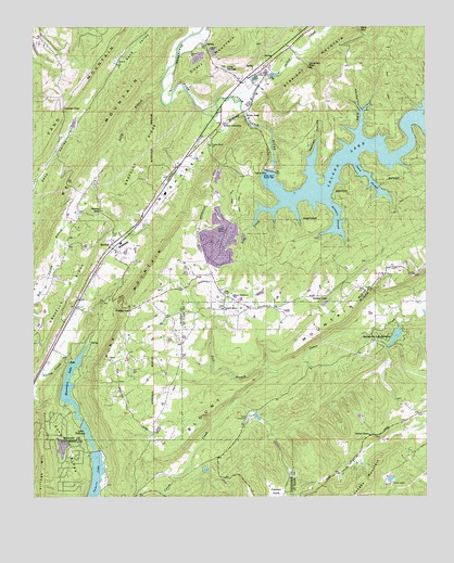
Remlap, AL USGS Topographic Map
Click on map above to begin viewing in our Map Viewer.

This topographic map contains these locations and features:
Feature Name Type Latitude Longitude GNIS ID View Map
Adams LakeReservoirN33.8318°W86.6133°131765View Map
Adams Lake DamDamN33.8318°W86.6133°131766View Map
Bear MountainSummitN33.7682°W86.5261°165010View Map
Bear Mountain BranchStreamN33.7757°W86.5617°165011View Map
Blount Highlands SchoolSchoolN33.8032°W86.5617°114506View Map
Camp TekawithaLocaleN33.7704°W86.5569°164590View Map
Camp UtopiaLocaleN33.7537°W86.5111°164591View Map
Campbell CreekStreamN33.8509°W86.5683°115495View Map
Clayton CoveValleyN33.7532°W86.5472°116209View Map
Clear SpringsPopulated PlaceN33.8634°W86.5642°156188View Map
Clear Springs CemeteryCemeteryN33.8643°W86.5642°1959598View Map
Clear Springs School (historical)SchoolN33.8645°W86.5636°135086View Map
Clear Springs United Methodist ChurchChurchN33.8634°W86.5642°135085View Map
Cowden GapGapN33.8643°W86.5375°116759View Map
Cowden Gap MineMineN33.8626°W86.5333°135091View Map
Fall BranchStreamN33.7834°W86.5472°164653View Map
Golden DamDamN33.8001°W86.5333°164977View Map
Golden LakeReservoirN33.8016°W86.5320°164669View Map
Gravelly RidgeRidgeN33.8240°W86.6025°119270View Map
Hulletts ChapelChurchN33.7662°W86.5180°164708View Map
Inland JunctionPopulated PlaceN33.8493°W86.5653°156513View Map
Inland LakeReservoirN33.8406°W86.5085°151859View Map
Inland LakeDamN33.8368°W86.5500°131770View Map
Inland Lake DamDamN33.8368°W86.5494°135113View Map
Johnson GapGapN33.8545°W86.5486°151445View Map
Jones SloughStreamN33.8401°W86.5233°121025View Map
Lake PittmanReservoirN33.7667°W86.6078°152963View Map
Lees ChapelChurchN33.8037°W86.5633°121480View Map
Mountain LakeReservoirN33.7801°W86.6130°123523View Map
Mountain Lake DamDamN33.7851°W86.6133°131741View Map
Nedham HollowValleyN33.8337°W86.5367°123670View Map
Pine MountainPopulated PlaceN33.8090°W86.5686°135147View Map
Pine MountainRidgeN33.7759°W86.6030°152931View Map
Pine Mountain Volunteer Fire and Emergency Medical Services Station 1BuildingN33.8029°W86.5614°2683057View Map
Pine Mountain Volunteer Fire and Emergency Medical Services Station 2BuildingN33.7947°W86.5739°2683461View Map
Pittman Lakes Dam Number 2DamN33.7684°W86.6083°131729View Map
Pleasant Mountain Baptist ChurchChurchN33.8001°W86.5650°164813View Map
Posey GapGapN33.7998°W86.5936°125187View Map
Red Valley ChurchChurchN33.8357°W86.6047°135151View Map
Reese GapGapN33.8265°W86.6036°125537View Map
RemlapPopulated PlaceN33.8168°W86.6008°125561View Map
Remlap ChurchChurchN33.8184°W86.5992°135152View Map
Remlap Post OfficePost OfficeN33.8173°W86.5995°167225View Map
Remlap Volunteer Fire Department Station 1BuildingN33.8169°W86.5999°2682713View Map
River GapGapN33.8518°W86.5575°125662View Map
Rock CreekStreamN33.8265°W86.5525°125752View Map
Rocking H Ranch LakeReservoirN33.8001°W86.5333°131753View Map
Saint Clair MountainSummitN33.8118°W86.5005°165342View Map
Sally BranchStreamN33.8573°W86.5842°126258View Map
Sand RidgeRidgeN33.7615°W86.6139°126326View Map
Sawmill SloughStreamN33.8295°W86.5322°126445View Map
Southeastern Elementary SchoolSchoolN33.8307°W86.5830°163870View Map
Springville Estate DamDamN33.7951°W86.5083°164976View Map
Springville LakeReservoirN33.7928°W86.5096°165204View Map
Springville Lake EstatesPopulated PlaceN33.7915°W86.5161°164865View Map
Swansea (historical)LocaleN33.8543°W86.5555°135182View Map
Tekawitha DamDamN33.7718°W86.5550°164972View Map
Tekawitha LakeReservoirN33.7713°W86.5539°164973View Map
Tucker GapGapN33.8534°W86.6155°128112View Map
Valley CreekStreamN33.8562°W86.5619°128388View Map
Valley Grove ChurchChurchN33.8434°W86.5689°128395View Map
Village MountainSummitN33.7584°W86.6217°128452View Map
Viola (historical)LocaleN33.8612°W86.5580°166048View Map
Viola Post Office (historical)Post OfficeN33.8612°W86.5580°169313View Map
Waid GapGapN33.8740°W86.5208°151654View Map
Wald HollowValleyN33.8468°W86.5217°128501View Map
Watseka (historical)Populated PlaceN33.8282°W86.5828°151444View Map
Woodhaven LakeReservoirN33.7633°W86.6159°140412View Map
Woodhaven Lake DamDamN33.7651°W86.6133°131726View Map
Zamora LakeReservoirN33.7519°W86.6059°154057View Map
Zamora Lake DamDamN33.7634°W86.6050°131725View Map

Note: Coordinates in the location and feature list above are referenced to NAD83 datum.


Copyright (C) 2008-2025 Ryan Niemi / Sunset Dynamics ... All Rights Reserved