TopoQuest Logo
Do you find TopoQuest useful?
Help keep TopoQuest running and adding new maps/features by donating!
Bitcoin:  19c7KJd3qBynnjoSw5npx9KScwjBe4ifkT
Litecoin:  LXs6TkuXGGXo1vDsWCkWVdjQX94eUKd6ui
Home View Maps Find Maps Find Places Resources & Links


Blount Springs, Alabama Topographic Map

USGS Map Title: Blount Springs, AL
USGS Map MRC: 33086H7
DRG (GeoTIFF) Download: o33086h7.tif


Neighboring USGS Topographic Map Quads:


  Trimble, AL  
34086A8
 

  Hanceville, AL  
34086A7
 

  Garden City, AL  
34086A6
 

  Arkadelphia, AL  
33086H8
 

  Blount Springs, AL  
33086H7
 

  Nectar, AL  
33086H6
 

  Creel, AL  
33086G8
 

  Warrior, AL  
33086G7
 

  Trafford, AL  
33086G6


Map MRC Location:

N34°
W87°
N34°
W86°
H8 H7 H6 H5 H4 H3 H2 H1
G8 G7 G6 G5 G4 G3 G2 G1
F8 F7 F6 F5 F4 F3 F2 F1
E8 E7 E6 E5 E4 E3 E2 E1
D8 D7 D6 D5 D4 D3 D2 D1
C8 C7 C6 C5 C4 C3 C2 C1
B8 B7 B6 B5 B4 B3 B2 B1
A8 A7 A6 A5 A4 A3 A2 A1
N33°
W87°
N33°
W86°

Blount Springs, AL USGS 1:24K Topographic Map Preview:
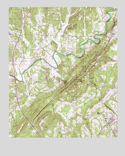
Blount Springs, AL USGS Topographic Map
Click on map above to begin viewing in our Map Viewer.

This topographic map contains these locations and features:
Feature Name Type Latitude Longitude GNIS ID View Map
BangorPopulated PlaceN33.9745°W86.7567°157883View Map
Bangor Volunteer Fire DepartmentBuildingN33.9683°W86.7629°2683257View Map
Barefoot MountainSummitN33.9901°W86.7992°113468View Map
Bent TreePopulated PlaceN33.8793°W86.7689°135073View Map
Bethlehem ChurchChurchN33.9104°W86.8011°114138View Map
Black BottomPopulated PlaceN33.9482°W86.8600°114396View Map
Blount SpringsPopulated PlaceN33.9312°W86.7942°114507View Map
Blount Springs ChurchChurchN33.9329°W86.7908°135078View Map
Blount Springs StationLocaleN33.9320°W86.7822°114508View Map
Blount TunnelTunnelN33.9368°W86.7822°114509View Map
Bryant MountainSummitN33.8929°W86.8347°115093View Map
Cedar Grove CemeteryCemeteryN33.9070°W86.7883°115779View Map
Chalybeate SpringSpringN33.8929°W86.7878°115914View Map
Cold SpringSpringN33.9229°W86.8072°163166View Map
Copperas GapGapN33.9995°W86.7717°163157View Map
Dairy CreekStreamN33.9209°W86.7703°117012View Map
DamascusPopulated PlaceN33.9748°W86.8736°1844226View Map
Damascus CemeteryCemeteryN33.9748°W86.8747°1805433View Map
Damascus ChurchChurchN33.9745°W86.8747°117035View Map
Dry CreekStreamN33.9254°W86.8064°117541View Map
Duffy MountainSummitN33.9518°W86.7769°117636View Map
Exit 287CrossingN33.8862°W86.8481°155567View Map
Exit 289CrossingN33.9118°W86.8653°155568View Map
Graves Gap ChurchChurchN33.9293°W86.7558°135096View Map
Hamilton MountainSummitN33.8851°W86.8611°119643View Map
Harrell CemeteryCemeteryN33.9054°W86.8014°119780View Map
Harrell CoveValleyN33.9209°W86.7703°119781View Map
HaydenPopulated PlaceN33.8926°W86.7578°119877View Map
Hayden DivisionCivilN33.8950°W86.8112°165664View Map
Hayden Elementary SchoolSchoolN33.8898°W86.7567°135102View Map
Hayden High SchoolSchoolN33.8976°W86.7733°119879View Map
Hayden MountainSummitN33.9207°W86.7575°119880View Map
Hayden Post OfficePost OfficeN33.8864°W86.7655°167206View Map
Hayden SchoolSchoolN33.8762°W86.7703°163862View Map
Hayden TunnelTunnelN33.9095°W86.7669°119881View Map
Huffman MountainSummitN33.9815°W86.7989°151817View Map
Interchange 292CrossingN33.9482°W86.8703°155569View Map
James CreekStreamN33.9290°W86.8594°120809View Map
Johnson GapGapN33.8770°W86.8689°135116View Map
Liberty ChurchChurchN33.8957°W86.7825°121556View Map
Marriott CreekStreamN33.9357°W86.8600°152228View Map
Mill CreekStreamN33.9434°W86.8258°122772View Map
Moody School (historical)SchoolN33.9723°W86.8314°134935View Map
Moore CemeteryCemeteryN33.9293°W86.7958°163865View Map
Mountain Brook ChurchChurchN33.9282°W86.8161°123504View Map
Mulberry Mill (historical)LocaleN33.9743°W86.7750°163161View Map
Murphy CreekStreamN33.9226°W86.8072°123602View Map
New Hope CemeteryCemeteryN33.9745°W86.8092°123789View Map
New Union Missionary Baptist ChurchChurchN33.9720°W86.7964°123913View Map
Providence ChurchChurchN33.8868°W86.7647°125336View Map
Reid GapGapN33.8784°W86.8425°163939View Map
ReidsPopulated PlaceN33.8868°W86.8483°154098View Map
Ricetown ChapelChurchN33.9318°W86.8514°135153View Map
Ricetown Volunteer Fire and RescueBuildingN33.9187°W86.8560°2683270View Map
Rickwood Caverns State ParkParkN33.8826°W86.8625°163868View Map
Sapp FordCrossingN33.9329°W86.8675°135161View Map
Smoke RisePopulated PlaceN33.8918°W86.8203°135171View Map
Smoke Rise Census Designated PlaceCensusN33.8790°W86.8241°2402861View Map
Spring Yard HillSummitN33.9312°W86.7894°127274View Map
Sulpher SpringsPopulated PlaceN33.9154°W86.8647°154100View Map
Sulphur SpringSpringN33.9301°W86.7930°127521View Map
Sulphur Springs SchoolSchoolN33.9143°W86.8667°127530View Map
Tedder CemeteryCemeteryN33.9790°W86.8167°127749View Map
Thacker CreekStreamN33.9576°W86.8192°153672View Map
The SinkBasinN33.8837°W86.8319°153679View Map
Town CreekStreamN33.9520°W86.8242°128034View Map
Town of HaydenCivilN33.8935°W86.7555°2405806View Map
Union Hill CemeteryCemeteryN33.9731°W86.8328°1805458View Map
Union Hill Church of ChristChurchN33.9718°W86.8322°128343View Map
West Blount Fire Department Station 1BuildingN33.8907°W86.7567°2682851View Map
West Blount Fire Department Station 2BuildingN33.8823°W86.8289°2683070View Map
West Blount Fire Department Station 4BuildingN33.9085°W86.7704°2683094View Map
Woods LakeReservoirN33.8812°W86.7522°131797View Map

Note: Coordinates in the location and feature list above are referenced to NAD83 datum.


Copyright (C) 2008-2025 Ryan Niemi / Sunset Dynamics ... All Rights Reserved