TopoQuest Logo
Do you find TopoQuest useful?
Help keep TopoQuest running and adding new maps/features by donating!
Bitcoin:  19c7KJd3qBynnjoSw5npx9KScwjBe4ifkT
Litecoin:  LXs6TkuXGGXo1vDsWCkWVdjQX94eUKd6ui
Home View Maps Find Maps Find Places Resources & Links


Neelys Landing, Missouri Topographic Map

USGS Map Title: Neelys Landing, MO
USGS Map MRC: 37089E5
DRG (GeoTIFF) Download: o37089e5.tif


Neighboring USGS Topographic Map Quads:


  Crosstown, MO  
37089F6
 

  Altenburg, MO  
37089F5
 

  Gorham, IL  
37089F4
 

  Oak Ridge, MO  
37089E6
 

  Neelys Landing, MO  
37089E5
 

  Wolf Lake, IL  
37089E4
 

  Jackson, MO  
37089D6
 

  Cape Girardeau NE, MO  
37089D5
 

  Ware, IL  
37089D4


Map MRC Location:

N38°
W90°
N38°
W89°
H8 H7 H6 H5 H4 H3 H2 H1
G8 G7 G6 G5 G4 G3 G2 G1
F8 F7 F6 F5 F4 F3 F2 F1
E8 E7 E6 E5 E4 E3 E2 E1
D8 D7 D6 D5 D4 D3 D2 D1
C8 C7 C6 C5 C4 C3 C2 C1
B8 B7 B6 B5 B4 B3 B2 B1
A8 A7 A6 A5 A4 A3 A2 A1
N37°
W90°
N37°
W89°

Neelys Landing, MO USGS 1:24K Topographic Map Preview:
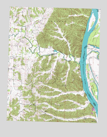
Neelys Landing, MO USGS Topographic Map
Click on map above to begin viewing in our Map Viewer.

This topographic map contains these locations and features:
Feature Name Type Latitude Longitude GNIS ID View Map
Apple CreekStreamN37.5656°W89.5270°713356View Map
Big Muddy RiverStreamN37.5737°W89.5170°404425View Map
BirminghamLocaleN37.5678°W89.5290°736433View Map
Birmingham HillsRangeN37.5876°W89.5659°736432View Map
Blue Shawnee CreekStreamN37.5653°W89.6245°714424View Map
Crawford LandingLocaleN37.5389°W89.5223°736005View Map
Crawford TowheadIslandN37.5367°W89.5059°406759View Map
Dog HollowValleyN37.5231°W89.5134°716957View Map
Dryden Post Light (historical)BuildingN37.6167°W89.5004°422200View Map
Gerler LakeReservoirN37.5776°W89.5607°718408View Map
High Hill SchoolSchoolN37.5406°W89.5445°719529View Map
Hines LandingPopulated PlaceN37.5578°W89.5265°740931View Map
LovejoyPopulated PlaceN37.5334°W89.5282°730544View Map
Lovejoy CreekStreamN37.5334°W89.5193°721620View Map
Muddy Shawnee CreekStreamN37.5653°W89.6245°723045View Map
Neelys CreekStreamN37.5048°W89.5001°723151View Map
Neelys LandingPopulated PlaceN37.5023°W89.5020°729353View Map
New Bethel ChurchChurchN37.5175°W89.5870°723184View Map
New WellsPopulated PlaceN37.5562°W89.6245°731626View Map
New Wells SchoolSchoolN37.5584°W89.6148°723323View Map
Oak Hill SchoolSchoolN37.5109°W89.5729°723624View Map
Patton CreekStreamN37.6039°W89.5193°736431View Map
Shawnee CreekStreamN37.5767°W89.5940°726293View Map
Sheppard SchoolSchoolN37.5045°W89.5193°726333View Map
Tower Island ChuteStreamN37.5842°W89.5170°727723View Map
Township of ShawneeCivilN37.5102°W89.5864°766402View Map
Union PointPopulated PlaceN37.5492°W89.5040°1725743View Map
Wilson LandingLocaleN37.5706°W89.5162°1725746View Map

Note: Coordinates in the location and feature list above are referenced to NAD83 datum.


Copyright (C) 2008-2025 Ryan Niemi / Sunset Dynamics ... All Rights Reserved