TopoQuest Logo
Do you find TopoQuest useful?
Help keep TopoQuest running and adding new maps/features by donating!
Bitcoin:  19c7KJd3qBynnjoSw5npx9KScwjBe4ifkT
Litecoin:  LXs6TkuXGGXo1vDsWCkWVdjQX94eUKd6ui
Home View Maps Find Maps Find Places Resources & Links


Jackson, Missouri Topographic Map

USGS Map Title: Jackson, MO
USGS Map MRC: 37089D6
DRG (GeoTIFF) Download: o37089d6.tif


Neighboring USGS Topographic Map Quads:


  Friedheim, MO  
37089E7
 

  Oak Ridge, MO  
37089E6
 

  Neelys Landing, MO  
37089E5
 

  Millersville, MO  
37089D7
 

  Jackson, MO  
37089D6
 

  Cape Girardeau NE, MO  
37089D5
 

  Burfordville, MO  
37089C7
 

  Gordonville, MO  
37089C6
 

  Cape Girardeau, MO  
37089C5


Map MRC Location:

N38°
W90°
N38°
W89°
H8 H7 H6 H5 H4 H3 H2 H1
G8 G7 G6 G5 G4 G3 G2 G1
F8 F7 F6 F5 F4 F3 F2 F1
E8 E7 E6 E5 E4 E3 E2 E1
D8 D7 D6 D5 D4 D3 D2 D1
C8 C7 C6 C5 C4 C3 C2 C1
B8 B7 B6 B5 B4 B3 B2 B1
A8 A7 A6 A5 A4 A3 A2 A1
N37°
W90°
N37°
W89°

Jackson, MO USGS 1:24K Topographic Map Preview:
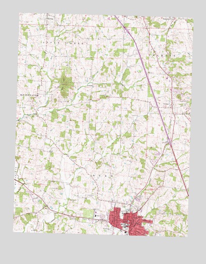
Jackson, MO USGS Topographic Map
Click on map above to begin viewing in our Map Viewer.

This topographic map contains these locations and features:
Feature Name Type Latitude Longitude GNIS ID View Map
Apple Creek CemeteryCemeteryN37.4989°W89.6284°713357View Map
BrooksidePopulated PlaceN37.4592°W89.6962°740698View Map
Byrd CemeteryCemeteryN37.4412°W89.7387°715163View Map
Byrd HillsRangeN37.4601°W89.7170°715166View Map
Cane Creek School (historical)SchoolN37.3859°W89.7348°748114View Map
Cape Girardeau CountyCivilN37.3840°W89.6845°758470View Map
Cape Girardeau County Sheriff's OfficeBuildingN37.3845°W89.6679°2752530View Map
City of JacksonCivilN37.3794°W89.6526°2395449View Map
Clifford SchoolSchoolN37.4703°W89.7434°748112View Map
Clippard CemeteryCemeteryN37.4762°W89.7426°716003View Map
Clover Hills SchoolSchoolN37.4031°W89.6357°748119View Map
Dogwood SchoolSchoolN37.4237°W89.6295°748117View Map
Franke LakeReservoirN37.4217°W89.6418°765000View Map
Franke Lake DamDamN37.4217°W89.6418°764999View Map
FruitlandPopulated PlaceN37.4487°W89.6387°731571View Map
Fruitland Area Fire Protection District Station 1BuildingN37.4644°W89.6402°2621084View Map
Horrell CemeteryCemeteryN37.3973°W89.6970°719845View Map
Horrell CreekStreamN37.4426°W89.7354°719846View Map
Horrell School (historical)SchoolN37.4867°W89.6934°748111View Map
Howard CemeteryCemeteryN37.4006°W89.7187°719910View Map
JacksonPopulated PlaceN37.3823°W89.6662°720202View Map
Jackson CemeteryCemeteryN37.3788°W89.6689°2681391View Map
Jackson Fire and Rescue DepartmentBuildingN37.3779°W89.6679°2621126View Map
Jackson Police DepartmentBuildingN37.3778°W89.6682°2752311View Map
Jackson Post OfficePost OfficeN37.3827°W89.6659°2782787View Map
KUGT-AM (Jackson)TowerN37.3817°W89.6520°759205View Map
McFerron SchoolSchoolN37.4217°W89.6757°748118View Map
Millersville Rural Fire Protection District Station 2BuildingN37.3895°W89.7280°2620373View Map
Mogler CemeteryCemeteryN37.3862°W89.7190°722513View Map
North Cape Girardeau County Fire District South StationBuildingN37.4995°W89.7316°2620852View Map
Pleasant Hill ChurchChurchN37.4523°W89.6279°724529View Map
Pocahontas StationLocaleN37.4928°W89.6579°748115View Map
R-2 SchoolSchoolN37.4453°W89.6290°725033View Map
Ramsey CemeteryCemeteryN37.4403°W89.7415°725091View Map
Roberts SchoolSchoolN37.4292°W89.7284°748113View Map
Russell CemeteryCemeteryN37.4434°W89.6670°725683View Map
Russell Heights CemeteryCemeteryN37.3781°W89.6795°725684View Map
Saint Johns ChurchChurchN37.4545°W89.6865°725779View Map
SawyerPopulated PlaceN37.4678°W89.6443°740431View Map
Sawyers SchoolSchoolN37.4656°W89.6390°754178View Map
Schoenebeck SchoolSchoolN37.4601°W89.6862°748116View Map
Shiloh CampLocaleN37.4789°W89.6423°726359View Map
Spring LakeReservoirN37.4223°W89.6474°764996View Map
Spring Lake DamDamN37.4217°W89.6468°764995View Map
Town of Oak RidgeCivilN37.4986°W89.7295°2396826View Map
Township of ByrdCivilN37.3960°W89.6928°766396View Map
Walker CemeteryCemeteryN37.3942°W89.7054°728256View Map
Weiss Roadside ParkParkN37.4289°W89.6429°728481View Map
Wheeler CemeteryCemeteryN37.4639°W89.7256°728688View Map

Note: Coordinates in the location and feature list above are referenced to NAD83 datum.


Copyright (C) 2008-2024 Ryan Niemi / Sunset Dynamics ... All Rights Reserved