TopoQuest Logo
Do you find TopoQuest useful?
Help keep TopoQuest running and adding new maps/features by donating!
Bitcoin:  19c7KJd3qBynnjoSw5npx9KScwjBe4ifkT
Litecoin:  LXs6TkuXGGXo1vDsWCkWVdjQX94eUKd6ui
Home View Maps Find Maps Find Places Resources & Links


Nemaha, Nebraska Topographic Map

USGS Map Title: Nemaha, NE
USGS Map MRC: 40095C6
DRG (GeoTIFF) Download: o40095c6.tif


Neighboring USGS Topographic Map Quads:


  Auburn, NE  
40095D7
 

  Peru, NE  
40095D6
 

  Rock Port, MO  
40095D5
 

  Howe, NE  
40095C7
 

  Nemaha, NE  
40095C6
 

  Langdon, MO  
40095C5
 

  Dawson, NE  
40095B7
 

  Verdon, NE  
40095B6
 

  Barada, NE  
40095B5


Map MRC Location:

N41°
W96°
N41°
W95°
H8 H7 H6 H5 H4 H3 H2 H1
G8 G7 G6 G5 G4 G3 G2 G1
F8 F7 F6 F5 F4 F3 F2 F1
E8 E7 E6 E5 E4 E3 E2 E1
D8 D7 D6 D5 D4 D3 D2 D1
C8 C7 C6 C5 C4 C3 C2 C1
B8 B7 B6 B5 B4 B3 B2 B1
A8 A7 A6 A5 A4 A3 A2 A1
N40°
W96°
N40°
W95°

Nemaha, NE USGS 1:24K Topographic Map Preview:
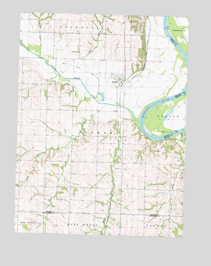
Nemaha, NE USGS Topographic Map
Click on map above to begin viewing in our Map Viewer.

This topographic map contains these locations and features:
Feature Name Type Latitude Longitude GNIS ID View Map
Aspinwall Post Office (historical)Post OfficeN40.3000°W95.6419°1883796View Map
Cooper Emergency Medical Response TeamBuildingN40.3621°W95.6412°2553672View Map
Cooper Spur (historical)LocaleN40.3611°W95.6544°1883795View Map
Deroin CreekStreamN40.3094°W95.6286°828685View Map
Happy HollowValleyN40.3488°W95.7026°829785View Map
Jarvis CreekStreamN40.3242°W95.6844°830347View Map
Little Nemaha RiverStreamN40.3142°W95.6592°830791View Map
Maple Grove SchoolSchoolN40.3531°W95.7064°831037View Map
NemahaPopulated PlaceN40.3383°W95.6730°831589View Map
Nemaha (historical)LocaleN40.3375°W95.6689°1883866View Map
Nemaha CemeteryCemeteryN40.3469°W95.6600°831590View Map
Nemaha Christian ChurchChurchN40.3383°W95.6730°1883863View Map
Nemaha Election PrecinctCivilN40.3054°W95.6855°1929087View Map
Nemaha Elevator Company ElevatorLocaleN40.3383°W95.6730°1883862View Map
Nemaha Post OfficePost OfficeN40.3380°W95.6731°1883864View Map
Nemaha Rescue SquadBuildingN40.3380°W95.6738°2553675View Map
Nemaha Volunteer Fire Department District 4BuildingN40.3376°W95.6733°2553247View Map
Penniwell CemeteryCemeteryN40.2619°W95.6994°832036View Map
Prairie Union Baptist ChurchChurchN40.2528°W95.7003°1883602View Map
Swartz RunStreamN40.3503°W95.7347°833986View Map
Township of NemahaCivilN40.3000°W95.7253°1883764View Map
United Methodist ChurchChurchN40.3383°W95.6730°1883865View Map
Village of NemahaCivilN40.3388°W95.6760°2399444View Map
Whisky RunStreamN40.3233°W95.6769°834666View Map

Note: Coordinates in the location and feature list above are referenced to NAD83 datum.


Copyright (C) 2008-2025 Ryan Niemi / Sunset Dynamics ... All Rights Reserved