TopoQuest Logo
Do you find TopoQuest useful?
Help keep TopoQuest running and adding new maps/features by donating!
Bitcoin:  19c7KJd3qBynnjoSw5npx9KScwjBe4ifkT
Litecoin:  LXs6TkuXGGXo1vDsWCkWVdjQX94eUKd6ui
Home View Maps Find Maps Find Places Resources & Links


Langdon, Missouri Topographic Map

USGS Map Title: Langdon, MO
USGS Map MRC: 40095C5
DRG (GeoTIFF) Download: o40095c5.tif


Neighboring USGS Topographic Map Quads:


  Peru, NE  
40095D6
 

  Rock Port, MO  
40095D5
 

  Tarkio West, MO  
40095D4
 

  Nemaha, NE  
40095C6
 

  Langdon, MO  
40095C5
 

  Fairfax, MO  
40095C4
 

  Verdon, NE  
40095B6
 

  Barada, NE  
40095B5
 

  Corning, MO  
40095B4


Map MRC Location:

N41°
W96°
N41°
W95°
H8 H7 H6 H5 H4 H3 H2 H1
G8 G7 G6 G5 G4 G3 G2 G1
F8 F7 F6 F5 F4 F3 F2 F1
E8 E7 E6 E5 E4 E3 E2 E1
D8 D7 D6 D5 D4 D3 D2 D1
C8 C7 C6 C5 C4 C3 C2 C1
B8 B7 B6 B5 B4 B3 B2 B1
A8 A7 A6 A5 A4 A3 A2 A1
N40°
W96°
N40°
W95°

Langdon, MO USGS 1:24K Topographic Map Preview:
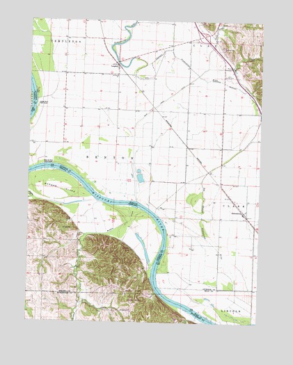
Langdon, MO USGS Topographic Map
Click on map above to begin viewing in our Map Viewer.

This topographic map contains these locations and features:
Feature Name Type Latitude Longitude GNIS ID View Map
Beadow CreekStreamN40.2975°W95.5658°827230View Map
Bend Center School (historical)SchoolN40.3386°W95.5933°736389View Map
Cooper School (historical)SchoolN40.3378°W95.5494°734331View Map
Excelsior School (historical)SchoolN40.3242°W95.6222°734329View Map
Hillsdale CemeteryCemeteryN40.2883°W95.6014°830014View Map
Hoot Owl Bend Public AccessLocaleN40.3153°W95.6122°743284View Map
Hunter CemeteryCemeteryN40.3636°W95.5219°720013View Map
Indian Cave State ParkParkN40.2528°W95.5544°1883548View Map
Indian Cave State Park TrailsTrailN40.2528°W95.5544°1883547View Map
LangdonPopulated PlaceN40.3564°W95.5797°741002View Map
Langdon Bend Public AccessLocaleN40.3400°W95.6211°743283View Map
Langdon School (historical)SchoolN40.3667°W95.5955°734328View Map
Lincoln School (historical)SchoolN40.2936°W95.5495°734332View Map
Luhrs Landing Strip (historical)AirportN40.3517°W95.5186°743393View Map
Morgan IslandIslandN40.3047°W95.6078°831412View Map
NishnabotnaPopulated PlaceN40.2958°W95.5086°741106View Map
Old Channel Nishnabotna RiverStreamN40.2642°W95.5119°723729View Map
Rock CreekStreamN40.3003°W95.5669°460724View Map
Rock Creek DitchCanalN40.3400°W95.5572°725451View Map
Saint Deroin (historical)Populated PlaceN40.2722°W95.5600°1883771View Map
Saint Deroin CemeteryCemeteryN40.2544°W95.5686°832855View Map
Saint Deroin Post Office (historical)Post OfficeN40.2722°W95.5600°1883770View Map
Saint Peters ChurchChurchN40.3522°W95.5794°725895View Map
State Line SloughStreamN40.3414°W95.6217°727039View Map
Township of BentonCivilN40.3303°W95.5764°766230View Map
Turkey CreekStreamN40.3556°W95.5303°727862View Map
West Bend School (historical)SchoolN40.3744°W95.5350°734330View Map

Note: Coordinates in the location and feature list above are referenced to NAD83 datum.


Copyright (C) 2008-2025 Ryan Niemi / Sunset Dynamics ... All Rights Reserved