TopoQuest Logo
Do you find TopoQuest useful?
Help keep TopoQuest running and adding new maps/features by donating!
Bitcoin:  19c7KJd3qBynnjoSw5npx9KScwjBe4ifkT
Litecoin:  LXs6TkuXGGXo1vDsWCkWVdjQX94eUKd6ui
Home View Maps Find Maps Find Places Resources & Links


Barada, Nebraska Topographic Map

USGS Map Title: Barada, NE
USGS Map MRC: 40095B5
DRG (GeoTIFF) Download: o40095b5.tif


Neighboring USGS Topographic Map Quads:


  Nemaha, NE  
40095C6
 

  Langdon, MO  
40095C5
 

  Fairfax, MO  
40095C4
 

  Verdon, NE  
40095B6
 

  Barada, NE  
40095B5
 

  Corning, MO  
40095B4
 

  Salem, NE  
40095A6
 

  Falls City, NE  
40095A5
 

  Rulo, NE  
40095A4


Map MRC Location:

N41°
W96°
N41°
W95°
H8 H7 H6 H5 H4 H3 H2 H1
G8 G7 G6 G5 G4 G3 G2 G1
F8 F7 F6 F5 F4 F3 F2 F1
E8 E7 E6 E5 E4 E3 E2 E1
D8 D7 D6 D5 D4 D3 D2 D1
C8 C7 C6 C5 C4 C3 C2 C1
B8 B7 B6 B5 B4 B3 B2 B1
A8 A7 A6 A5 A4 A3 A2 A1
N40°
W96°
N40°
W95°

Barada, NE USGS 1:24K Topographic Map Preview:
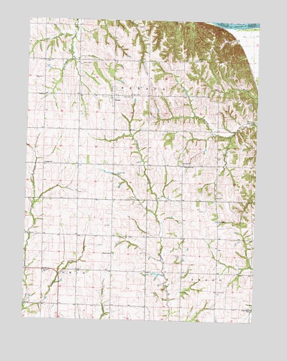
Barada, NE USGS Topographic Map
Click on map above to begin viewing in our Map Viewer.

This topographic map contains these locations and features:
Feature Name Type Latitude Longitude GNIS ID View Map
Antoine Barada MarkerParkN40.2186°W95.5778°1883597View Map
Arago Center SchoolSchoolN40.1303°W95.5005°827032View Map
Arago SchoolSchoolN40.1369°W95.5392°827033View Map
BaradaPopulated PlaceN40.2186°W95.5778°827181View Map
Barada Election PrecinctCivilN40.2169°W95.5771°1928705View Map
Barada Post Office (historical)Post OfficeN40.2186°W95.5778°1883539View Map
Barada United Methodist ChurchChurchN40.2186°W95.5778°1883603View Map
Berg CemeteryCemeteryN40.2258°W95.6172°827337View Map
Feicht SchoolSchoolN40.2183°W95.6153°829283View Map
Franklin SchoolSchoolN40.1900°W95.6153°829390View Map
Fricke CemeteryCemeteryN40.1517°W95.5394°829418View Map
Glendale SchoolSchoolN40.1525°W95.5778°829538View Map
Harris CemeteryCemeteryN40.2183°W95.5733°829820View Map
Moorhead CemeteryCemeteryN40.2331°W95.6153°831407View Map
Ohio Election PrecinctCivilN40.1312°W95.6150°1929117View Map
Saint Anns CemeteryCemeteryN40.2189°W95.5686°832830View Map
Saint John CemeteryCemeteryN40.1375°W95.5191°832880View Map
Saint Paul SchoolSchoolN40.1453°W95.6142°833057View Map
Saint Peters ChurchChurchN40.1900°W95.5394°833097View Map
Saint Stephens Post Office (historical)Post OfficeN40.1903°W95.5392°1883518View Map
School Number 1SchoolN40.2339°W95.5319°836100View Map
Stumps Station (historical)LocaleN40.1889°W95.5397°1883512View Map
Temple CreekStreamN40.1286°W95.6244°834065View Map
Township of AragoCivilN40.1264°W95.5008°1883502View Map
Township of BaradaCivilN40.2083°W95.5836°1883501View Map
Township of OhioCivilN40.1306°W95.6142°1883500View Map
Village of BaradaCivilN40.2185°W95.5778°2398030View Map
Williamsville (historical)Populated PlaceN40.1889°W95.5397°1883510View Map
Williamsville Post Office (historical)Post OfficeN40.1889°W95.5397°1883511View Map
Williamsville SchoolSchoolN40.1892°W95.5394°834759View Map
Winnebago Creek Dam 41-3ADamN40.1488°W95.5014°1769878View Map
Winnebago Creek Dam 41-4DamN40.1517°W95.5036°1769800View Map
Winnebago Creek Dam 41-5DamN40.1517°W95.5036°1769880View Map
Winnebago Creek Reservoir 41-3AReservoirN40.1476°W95.5048°1769879View Map
Winnebago Creek Reservoir 41-4ReservoirN40.1517°W95.5036°1769801View Map
Winnebago Creek Reservoir 41-5ReservoirN40.1517°W95.5036°1769881View Map

Note: Coordinates in the location and feature list above are referenced to NAD83 datum.


Copyright (C) 2008-2024 Ryan Niemi / Sunset Dynamics ... All Rights Reserved