TopoQuest Logo
Do you find TopoQuest useful?
Help keep TopoQuest running and adding new maps/features by donating!
Bitcoin:  19c7KJd3qBynnjoSw5npx9KScwjBe4ifkT
Litecoin:  LXs6TkuXGGXo1vDsWCkWVdjQX94eUKd6ui
Home View Maps Find Maps Find Places Resources & Links


New Augusta, Mississippi Topographic Map

USGS Map Title: New Augusta, MS
USGS Map MRC: 31089B1
DRG (GeoTIFF) Download: o31089b1.tif


Neighboring USGS Topographic Map Quads:


  Carterville, MS  
31089C2
 

  Ovett SE, MS  
31089C1
 

  Richton, MS  
31088C8
 

  McLaurin, MS  
31089B2
 

  New Augusta, MS  
31089B1
 

  Beaumont, MS  
31088B8
 

  Brooklyn, MS  
31089A2
 

  Janice, MS  
31089A1
 

  Taylor Hill, MS  
31088A8


Map MRC Location:

N32°
W90°
N32°
W89°
H8 H7 H6 H5 H4 H3 H2 H1
G8 G7 G6 G5 G4 G3 G2 G1
F8 F7 F6 F5 F4 F3 F2 F1
E8 E7 E6 E5 E4 E3 E2 E1
D8 D7 D6 D5 D4 D3 D2 D1
C8 C7 C6 C5 C4 C3 C2 C1
B8 B7 B6 B5 B4 B3 B2 B1
A8 A7 A6 A5 A4 A3 A2 A1
N31°
W90°
N31°
W89°

New Augusta, MS USGS 1:24K Topographic Map Preview:
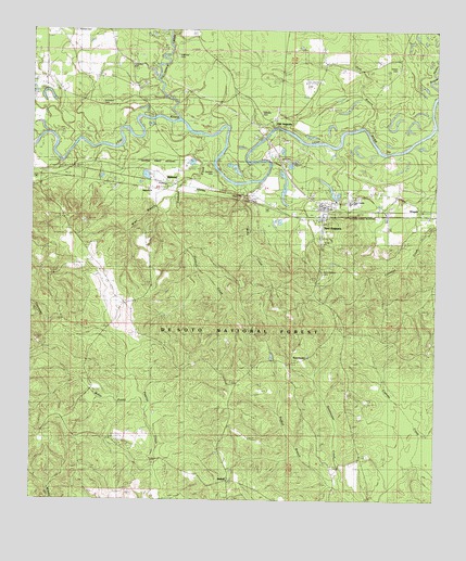
New Augusta, MS USGS Topographic Map
Click on map above to begin viewing in our Map Viewer.

This topographic map contains these locations and features:
Feature Name Type Latitude Longitude GNIS ID View Map
Biloxi Regional Sewer Treatment Plant WestLocaleN31.2336°W89.0462°2596117View Map
Burleman BranchStreamN31.2488°W89.0828°692767View Map
Davis KD RangeLocaleN31.1416°W89.0953°705616View Map
Denham CemeteryCemeteryN31.2130°W89.0700°705612View Map
Denham CreekStreamN31.2221°W89.0717°693082View Map
Ferguson CemeteryCemeteryN31.2410°W89.0939°704605View Map
Goodhope Baptist ChurchChurchN31.1995°W89.0364°2596578View Map
Gum BranchStreamN31.2238°W89.0253°693384View Map
Hinton CemeteryCemeteryN31.2399°W89.0123°693488View Map
Hollimon CemeteryCemeteryN31.2432°W89.0806°704614View Map
MahnedPopulated PlaceN31.2091°W89.0809°693868View Map
Mahned BridgeBridgeN31.2268°W89.0874°2596182View Map
Mahned ChurchChurchN31.2077°W89.0892°704624View Map
McKenzie CemeteryCemeteryN31.2302°W89.1037°704625View Map
McSwain CemeteryCemeteryN31.2155°W89.0453°704627View Map
Miles BranchStreamN31.2057°W89.0814°705611View Map
Milky CreekStreamN31.2093°W89.0562°693968View Map
New AugustaPopulated PlaceN31.2024°W89.0348°694154View Map
New Augusta CemeteryCemeteryN31.1843°W89.0350°694155View Map
New Augusta Elementary SchoolSchoolN31.2045°W89.0267°705946View Map
New Augusta Fire DepartmentBuildingN31.1999°W89.0368°2332765View Map
New Augusta Police DepartmentBuildingN31.2038°W89.0357°2332923View Map
New Augusta Post OfficePost OfficeN31.2042°W89.0339°2768847View Map
New Augusta Volunteer Fire DepartmentBuildingN31.2001°W89.0324°2332753View Map
New Augusta Volunteer Fire DepartmentBuildingN31.2044°W89.0358°2332816View Map
Nichols CemeteryCemeteryN31.2496°W89.1117°704632View Map
Old AugustaLocaleN31.2243°W89.0498°694254View Map
Old Augusta Boat RampLocaleN31.2242°W89.0508°2596221View Map
Perry Central High SchoolSchoolN31.1987°W89.0265°711689View Map
Perry County Sheriff's OfficeBuildingN31.2048°W89.0354°2332891View Map
Red Hill School (historical)SchoolN31.1310°W89.0634°704636View Map
RedhillPopulated PlaceN31.1299°W89.0642°694539View Map
Redhill BranchStreamN31.1277°W89.0281°694540View Map
Stevens CemeteryCemeteryN31.2282°W89.0537°694890View Map
Supervisor District 1CivilN31.2121°W89.0129°712026View Map
SweetwaterLocaleN31.1624°W89.0437°705610View Map
Sweetwater CemeteryCemeteryN31.1627°W89.0437°694916View Map
Sweetwater Church (historical)ChurchN31.1621°W89.0434°704641View Map
Tallahala CreekStreamN31.2266°W89.0801°694932View Map
Town of New AugustaCivilN31.2036°W89.0274°2406972View Map
Water ProngStreamN31.1491°W89.0889°705623View Map
Water Valley Sewage LagoonLocaleN31.2350°W89.0514°2597023View Map
WingatePopulated PlaceN31.2027°W89.0014°695195View Map

Note: Coordinates in the location and feature list above are referenced to NAD83 datum.


Copyright (C) 2008-2024 Ryan Niemi / Sunset Dynamics ... All Rights Reserved