TopoQuest Logo
Do you find TopoQuest useful?
Help keep TopoQuest running and adding new maps/features by donating!
Bitcoin:  19c7KJd3qBynnjoSw5npx9KScwjBe4ifkT
Litecoin:  LXs6TkuXGGXo1vDsWCkWVdjQX94eUKd6ui
Home View Maps Find Maps Find Places Resources & Links


New Castle East, Indiana Topographic Map

USGS Map Title: New Castle East, IN
USGS Map MRC: 39085H3
DRG (GeoTIFF) Download: o39085h3.tif


Neighboring USGS Topographic Map Quads:


  Sulphur Springs, IN  
40085A4
 

  Mount Pleasant, IN  
40085A3
 

  Modoc, IN  
40085A2
 

  New Castle West, IN  
39085H4
 

  New Castle East, IN  
39085H3
 

  Hagerstown, IN  
39085H2
 

  Dunreith, IN  
39085G4
 

  Lewisville, IN  
39085G3
 

  Cambridge City, IN  
39085G2


Map MRC Location:

N40°
W86°
N40°
W85°
H8 H7 H6 H5 H4 H3 H2 H1
G8 G7 G6 G5 G4 G3 G2 G1
F8 F7 F6 F5 F4 F3 F2 F1
E8 E7 E6 E5 E4 E3 E2 E1
D8 D7 D6 D5 D4 D3 D2 D1
C8 C7 C6 C5 C4 C3 C2 C1
B8 B7 B6 B5 B4 B3 B2 B1
A8 A7 A6 A5 A4 A3 A2 A1
N39°
W86°
N39°
W85°

New Castle East, IN USGS 1:24K Topographic Map Preview:
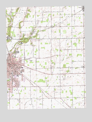
New Castle East, IN USGS Topographic Map
Click on map above to begin viewing in our Map Viewer.

This topographic map contains these locations and features:
Feature Name Type Latitude Longitude GNIS ID View Map
Alten DitchCanalN39.9603°W85.2991°430121View Map
Aqua RunStreamN39.9756°W85.3614°430229View Map
AshlandPopulated PlaceN39.9262°W85.3044°430310View Map
Ashland SchoolSchoolN39.9303°W85.3036°430311View Map
Babe Ruth ParkParkN39.9137°W85.3700°430378View Map
Bat RunStreamN39.9162°W85.2666°430570View Map
Batson ChurchChurchN39.9103°W85.2847°430576View Map
Batson DrainStreamN39.9175°W85.2889°430577View Map
Battle BrookStreamN39.9873°W85.3694°430578View Map
BelmontPopulated PlaceN39.9217°W85.3497°430785View Map
Black DitchCanalN39.9795°W85.3077°431134View Map
Blue River Township Fire DepartmentBuildingN39.9971°W85.2503°2701478View Map
Boulder RunStreamN39.8787°W85.3475°431377View Map
Brown RunStreamN39.9928°W85.3514°431632View Map
City of New CastleCivilN39.9190°W85.3698°2395191View Map
Colony CreekStreamN39.9628°W85.3386°432810View Map
Coo RunStreamN39.8764°W85.2536°432910View Map
CorwinPopulated PlaceN39.8884°W85.2991°452168View Map
Foster DitchCanalN39.8953°W85.3308°434703View Map
Gravel RunStreamN39.8973°W85.3130°435360View Map
Green RunStreamN39.9956°W85.3500°435413View Map
Hauffman DitchCanalN39.9806°W85.2825°435882View Map
Henry Community Health Medical GroupHospitalN39.9433°W85.3630°2660451View Map
Henry County Sheriff Department Emergency Medical ServiceBuildingN39.9314°W85.3718°2701480View Map
Henry County Sheriff's OfficeBuildingN39.9320°W85.3720°2758335View Map
Hernly SchoolSchoolN39.9217°W85.3614°436059View Map
Hillcrest BrookStreamN39.9512°W85.3691°436201View Map
HillsboroPopulated PlaceN39.9681°W85.3316°436215View Map
Indiana Village for Epileptics (historical)HospitalN39.9620°W85.3616°436806View Map
James Whitcomb Riley Elementary SchoolSchoolN39.9020°W85.3714°442032View Map
Kessinger CemeteryCemeteryN39.9660°W85.2509°2745826View Map
Lavender RunStreamN39.9917°W85.3516°437659View Map
Lick BranchStreamN39.9764°W85.3608°437850View Map
Little Blue RiverStreamN39.9498°W85.3714°437993View Map
Livezey CemeteryCemeteryN39.9885°W85.3654°438186View Map
Mercer DitchCanalN39.8803°W85.3189°439015View Map
MessickPopulated PlaceN39.9753°W85.3027°439043View Map
MillvillePopulated PlaceN39.9248°W85.2519°439249View Map
Millville - Liberty Township Fire DepartmentBuildingN39.9264°W85.2515°2625922View Map
Millville DrainStreamN39.9175°W85.2889°439250View Map
Moonshine RunStreamN39.9631°W85.3341°439386View Map
MoorelandPopulated PlaceN39.9975°W85.2511°439408View Map
Mooreland Police DepartmentBuildingN39.9967°W85.2509°2758303View Map
Mooreland Volunteer Fire DepartmentBuildingN39.9972°W85.2502°2626140View Map
Mud RunStreamN39.9056°W85.3077°439844View Map
Nation DitchCanalN39.8834°W85.2516°439946View Map
New CastlePopulated PlaceN39.9289°W85.3702°440031View Map
New Castle Correctional FacilityBuildingN39.9621°W85.3717°2757185View Map
New Castle Emergency Medical ServiceBuildingN39.9168°W85.3688°2701477View Map
New Castle Fire Department Station 1BuildingN39.9330°W85.3705°2626005View Map
New Castle Fire Department Station 2BuildingN39.9229°W85.3536°2625671View Map
New Castle Fire Department Station 3BuildingN39.9100°W85.3703°2625665View Map
New Castle Municipal Airport (historical)AirportN39.9348°W85.3402°449282View Map
New Castle Police DepartmentBuildingN39.9329°W85.3708°2758485View Map
New Castle State Developmental CenterHospitalN39.9620°W85.3616°2729827View Map
Number One ArmStreamN39.9356°W85.2836°440367View Map
Number Two ArmStreamN39.9498°W85.2814°440368View Map
Parker Elementary SchoolSchoolN39.9187°W85.3700°440888View Map
Pebble RunStreamN39.9075°W85.2994°440964View Map
Penns RunStreamN39.9484°W85.3725°441000View Map
Pierson StationPopulated PlaceN39.9034°W85.3264°452169View Map
Red RunStreamN39.9895°W85.3514°441825View Map
Slo RunStreamN39.9703°W85.3325°443610View Map
Stone BranchStreamN39.9170°W85.2927°444198View Map
Suncrest BrookStreamN39.9598°W85.3336°444406View Map
Town of MoorelandCivilN39.9974°W85.2513°2396778View Map
Township of Blue RiverCivilN39.9891°W85.2558°453119View Map
Township of LibertyCivilN39.9169°W85.2645°453556View Map
Upper Big Blue River Structure Number 15DamN39.9584°W85.3333°447613View Map
Van NuysPopulated PlaceN39.9600°W85.3539°445215View Map
Wantz DitchCanalN39.8864°W85.3202°445459View Map
Weir SchoolSchoolN39.9295°W85.3600°445644View Map
White Heart CemeteryCemeteryN39.8767°W85.2758°445940View Map
White Jersey FarmLocaleN39.9283°W85.3056°2628455View Map
Wilbur Wright Elementary SchoolSchoolN39.9398°W85.3622°447068View Map
Yellow RunStreamN39.9959°W85.3500°446387View Map

Note: Coordinates in the location and feature list above are referenced to NAD83 datum.


Copyright (C) 2008-2024 Ryan Niemi / Sunset Dynamics ... All Rights Reserved