TopoQuest Logo
Do you find TopoQuest useful?
Help keep TopoQuest running and adding new maps/features by donating!
Bitcoin:  19c7KJd3qBynnjoSw5npx9KScwjBe4ifkT
Litecoin:  LXs6TkuXGGXo1vDsWCkWVdjQX94eUKd6ui
Home View Maps Find Maps Find Places Resources & Links


Hagerstown, Indiana Topographic Map

USGS Map Title: Hagerstown, IN
USGS Map MRC: 39085H2
DRG (GeoTIFF) Download: o39085h2.tif


Neighboring USGS Topographic Map Quads:


  Mount Pleasant, IN  
40085A3
 

  Modoc, IN  
40085A2
 

  Carlos, IN  
40085A1
 

  New Castle East, IN  
39085H3
 

  Hagerstown, IN  
39085H2
 

  Greens Fork, IN  
39085H1
 

  Lewisville, IN  
39085G3
 

  Cambridge City, IN  
39085G2
 

  Jacksonburg, IN  
39085G1


Map MRC Location:

N40°
W86°
N40°
W85°
H8 H7 H6 H5 H4 H3 H2 H1
G8 G7 G6 G5 G4 G3 G2 G1
F8 F7 F6 F5 F4 F3 F2 F1
E8 E7 E6 E5 E4 E3 E2 E1
D8 D7 D6 D5 D4 D3 D2 D1
C8 C7 C6 C5 C4 C3 C2 C1
B8 B7 B6 B5 B4 B3 B2 B1
A8 A7 A6 A5 A4 A3 A2 A1
N39°
W86°
N39°
W85°

Hagerstown, IN USGS 1:24K Topographic Map Preview:
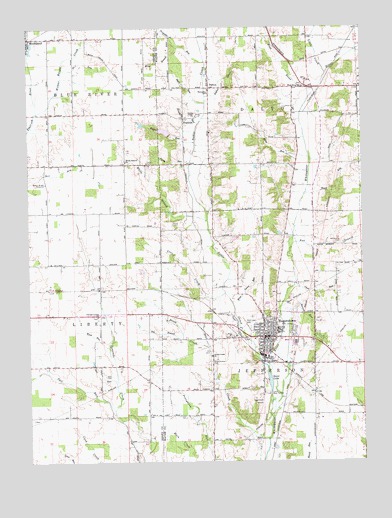
Hagerstown, IN USGS Topographic Map
Click on map above to begin viewing in our Map Viewer.

This topographic map contains these locations and features:
Feature Name Type Latitude Longitude GNIS ID View Map
Awl BranchStreamN39.9370°W85.1511°430361View Map
Bales CemeteryCemeteryN39.9612°W85.2052°432964View Map
Bat BranchStreamN39.9106°W85.1922°430569View Map
Bear CreekStreamN39.8817°W85.1600°430616View Map
Bell CemeteryCemeteryN39.8999°W85.2215°430756View Map
Bell RunStreamN39.8978°W85.2177°430770View Map
Brick Church CemeteryCemeteryN39.9040°W85.1824°431506View Map
Brick CreekStreamN39.9081°W85.1825°431507View Map
Camp Wapi KamigiParkN39.8948°W85.1597°432073View Map
Chicago Corner ChurchChurchN39.9170°W85.2244°432469View Map
Civil RunStreamN39.9253°W85.1500°432541View Map
Corey RunStreamN39.9598°W85.1891°432965View Map
Culberson Emergency Medical ServicesBuildingN39.9103°W85.1621°2719292View Map
DaltonPopulated PlaceN39.9834°W85.1814°447636View Map
Dalton DrainCanalN39.9803°W85.1827°433297View Map
Dawn Lake DamDamN39.9717°W85.2000°447907View Map
Flight RunStreamN39.9670°W85.1866°434597View Map
FranklinPopulated PlaceN39.9739°W85.1911°449869View Map
Franklin RunStreamN39.9725°W85.1858°434775View Map
HagerstownPopulated PlaceN39.9112°W85.1616°452048View Map
Hagerstown AirportAirportN39.8942°W85.1626°449192View Map
Hagerstown Indiana Fire DepartmentBuildingN39.9123°W85.1608°2625552View Map
Hagerstown Police DepartmentBuildingN39.9114°W85.1609°2758154View Map
Hartley RunStreamN39.9203°W85.1483°435829View Map
House Gravel PitMineN39.9228°W85.1511°2649438View Map
Little CreekStreamN39.9864°W85.1380°438030View Map
Mono RunStreamN39.9625°W85.1441°439332View Map
Nettle CreekStreamN39.9025°W85.1605°440005View Map
Nettle Creek ChurchChurchN39.9056°W85.1816°440007View Map
Nettle Creek ChurchChurchN39.9748°W85.1866°440008View Map
Number Four ArmStreamN39.9881°W85.2366°440369View Map
Olive Branch CemeteryCemeteryN39.9379°W85.1357°430362View Map
Propeller RunStreamN39.9900°W85.1827°441608View Map
Scout LakeLakeN39.8979°W85.1600°443171View Map
Show RunStreamN39.9784°W85.1827°443458View Map
Single RunStreamN39.9523°W85.1455°443548View Map
Tail RunStreamN39.8898°W85.2183°444548View Map
Town of HagerstownCivilN39.9115°W85.1555°2396981View Map
Township of DaltonCivilN39.9759°W85.1635°453252View Map
Township of JeffersonCivilN39.9123°W85.1482°453502View Map
Ulrich CemeteryCemeteryN39.9434°W85.1959°445038View Map
Ulrich CreekStreamN39.9234°W85.1761°445039View Map
West Lawn CemeteryCemeteryN39.9142°W85.1668°445778View Map
West Lawn RunStreamN39.9212°W85.1736°445779View Map
West RiverStreamN39.9798°W85.1444°445806View Map
West River ChurchChurchN39.9831°W85.1466°445807View Map
White BranchStreamN39.9448°W85.1825°445920View Map
White Branch ChurchChurchN39.9614°W85.2133°445921View Map
Wilbur Wright CreekStreamN39.9756°W85.2466°446012View Map
Wilbur Wright MemorialParkN39.9553°W85.2433°446013View Map
Wind RunStreamN39.9081°W85.2205°446169View Map
Wing BranchStreamN39.9942°W85.1927°446180View Map

Note: Coordinates in the location and feature list above are referenced to NAD83 datum.


Copyright (C) 2008-2025 Ryan Niemi / Sunset Dynamics ... All Rights Reserved