TopoQuest Logo
Do you find TopoQuest useful?
Help keep TopoQuest running and adding new maps/features by donating!
Bitcoin:  19c7KJd3qBynnjoSw5npx9KScwjBe4ifkT
Litecoin:  LXs6TkuXGGXo1vDsWCkWVdjQX94eUKd6ui
Home View Maps Find Maps Find Places Resources & Links


Belle Plaine, Kansas Topographic Map

USGS Map Title: Belle Plaine, KS
USGS Map MRC: 37097D3
DRG (GeoTIFF) Download: o37097d3.tif


Neighboring USGS Topographic Map Quads:


  Bayneville, KS  
37097E4
 

  Derby, KS  
37097E3
 

  Rose Hill, KS  
37097E2
 

  Zyba, KS  
37097D4
 

  Belle Plaine, KS  
37097D3
 

  Mulvane, KS  
37097D2
 

  Wellington, KS  
37097C4
 

  Dalton, KS  
37097C3
 

  Oxford, KS  
37097C2


Map MRC Location:

N38°
W98°
N38°
W97°
H8 H7 H6 H5 H4 H3 H2 H1
G8 G7 G6 G5 G4 G3 G2 G1
F8 F7 F6 F5 F4 F3 F2 F1
E8 E7 E6 E5 E4 E3 E2 E1
D8 D7 D6 D5 D4 D3 D2 D1
C8 C7 C6 C5 C4 C3 C2 C1
B8 B7 B6 B5 B4 B3 B2 B1
A8 A7 A6 A5 A4 A3 A2 A1
N37°
W98°
N37°
W97°

Belle Plaine, KS USGS 1:24K Topographic Map Preview:
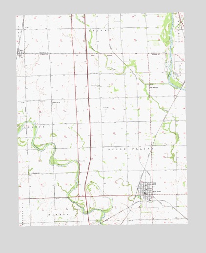
Belle Plaine, KS USGS Topographic Map
Click on map above to begin viewing in our Map Viewer.

This topographic map contains these locations and features:
Feature Name Type Latitude Longitude GNIS ID View Map
Bartlett ArboretumLocaleN37.3916°W97.2867°2692669View Map
Belle PlainePopulated PlaceN37.3939°W97.2812°470240View Map
Belle Plaine CemeteryCemeteryN37.3867°W97.2845°2673352View Map
Belle Plaine Church of ChristChurchN37.3989°W97.2717°2690196View Map
Belle Plaine City HallBuildingN37.3926°W97.2815°2693090View Map
Belle Plaine Elementary SchoolSchoolN37.3954°W97.2807°2497364View Map
Belle Plaine Emergency Medical ServicesBuildingN37.3926°W97.2804°2696540View Map
Belle Plaine High SchoolSchoolN37.3989°W97.2807°2497578View Map
Belle Plaine Middle SchoolSchoolN37.3967°W97.2807°2497557View Map
Belle Plaine Police DepartmentBuildingN37.3931°W97.2765°2504231View Map
Belle Plaine Post OfficePost OfficeN37.3927°W97.2816°2509626View Map
Belle Plaine Presbyterian ChurchChurchN37.3944°W97.2807°2690565View Map
Belle Plaine Public LibraryBuildingN37.3939°W97.2820°2694689View Map
Belle Plaine United Methodist ChurchChurchN37.4001°W97.2784°2689630View Map
Belle Plaine Wastewater Treatment PlantLocaleN37.3796°W97.2833°2691952View Map
City of Belle PlaineCivilN37.3938°W97.2796°2394114View Map
Council Hill ChurchChurchN37.4475°W97.3493°470235View Map
Cowskin Creek CutoffCanalN37.4578°W97.2703°470237View Map
First Baptist ChurchChurchN37.3954°W97.2821°2689938View Map
Kendrigan Airport (historical)AirportN37.4526°W97.3155°481320View Map
London (historical)LocaleN37.4397°W97.3600°482640View Map
London SchoolSchoolN37.4492°W97.3589°470234View Map
Meekers SchoolSchoolN37.4134°W97.3309°470241View Map
Meridian SchoolSchoolN37.4064°W97.3645°470242View Map
Mulvane Wastewater Treatment FacilityLocaleN37.4666°W97.2579°2691895View Map
New Salem SchoolSchoolN37.4578°W97.2703°470238View Map
PeckPopulated PlaceN37.4775°W97.3723°470233View Map
Prairie Garden CemeteryCemeteryN37.4650°W97.3151°470232View Map
Rands AirportAirportN37.4264°W97.2695°2675716View Map
RiverdalePopulated PlaceN37.3900°W97.3725°470163View Map
Sumner County Fire District 9 Belle PlaineBuildingN37.3893°W97.2768°2111919View Map
Township of Belle PlaineCivilN37.4228°W97.2942°470222View Map
Valley Mobile Home ParkPopulated PlaceN37.4000°W97.2839°2694179View Map

Note: Coordinates in the location and feature list above are referenced to NAD83 datum.


Copyright (C) 2008-2025 Ryan Niemi / Sunset Dynamics ... All Rights Reserved