TopoQuest Logo
Do you find TopoQuest useful?
Help keep TopoQuest running and adding new maps/features by donating!
Bitcoin:  19c7KJd3qBynnjoSw5npx9KScwjBe4ifkT
Litecoin:  LXs6TkuXGGXo1vDsWCkWVdjQX94eUKd6ui
Home View Maps Find Maps Find Places Resources & Links


Newark, Arkansas Topographic Map

USGS Map Title: Newark, AR
USGS Map MRC: 35091F4
DRG (GeoTIFF) Download: o35091f4.tif


Neighboring USGS Topographic Map Quads:


  Sulphur Rock, AR  
35091G5
 

  Charlotte, AR  
35091G4
 

  Cord, AR  
35091G3
 

  Salado, AR  
35091F5
 

  Newark, AR  
35091F4
 

  Jacksonport, AR  
35091F3
 

  Huff, AR  
35091E5
 

  Olyphant, AR  
35091E4
 

  Newport, AR  
35091E3


Map MRC Location:

N36°
W92°
N36°
W91°
H8 H7 H6 H5 H4 H3 H2 H1
G8 G7 G6 G5 G4 G3 G2 G1
F8 F7 F6 F5 F4 F3 F2 F1
E8 E7 E6 E5 E4 E3 E2 E1
D8 D7 D6 D5 D4 D3 D2 D1
C8 C7 C6 C5 C4 C3 C2 C1
B8 B7 B6 B5 B4 B3 B2 B1
A8 A7 A6 A5 A4 A3 A2 A1
N35°
W92°
N35°
W91°

Newark, AR USGS 1:24K Topographic Map Preview:
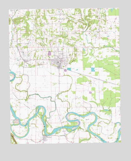
Newark, AR USGS Topographic Map
Click on map above to begin viewing in our Map Viewer.

This topographic map contains these locations and features:
Feature Name Type Latitude Longitude GNIS ID View Map
Akron (historical)Populated PlaceN35.6662°W91.4487°67971View Map
Akron CemeteryCemeteryN35.6653°W91.4493°45800View Map
Bear Wallow SloughStreamN35.6356°W91.4104°46242View Map
Big Bottom SloughStreamN35.6437°W91.4596°46507View Map
Blue Springs CemeteryCemeteryN35.7106°W91.4487°46768View Map
Caster BendBendN35.6520°W91.4343°59255View Map
Cedar Ridge High SchoolSchoolN35.7203°W91.4455°2092989View Map
City of NewarkCivilN35.7084°W91.4434°2404368View Map
Crow IslandIslandN35.6462°W91.4935°48229View Map
Dugger CemeteryCemeteryN35.7359°W91.4596°48688View Map
DunningtonPopulated PlaceN35.6254°W91.4287°57687View Map
Eaves CemeteryCemeteryN35.7456°W91.4171°48793View Map
Edwards CemeteryCemeteryN35.7426°W91.3912°48822View Map
Ellison CemeteryCemeteryN35.6320°W91.4985°48865View Map
Fetser CemeteryCemeteryN35.7253°W91.4001°49033View Map
Feutral CemeteryCemeteryN35.7184°W91.4787°49034View Map
Fivemile CreekStreamN35.7379°W91.4140°49082View Map
Gibbs CreekStreamN35.7415°W91.4974°49389View Map
Hulsey BendBendN35.6462°W91.4174°50403View Map
Independence Power PlantBuildingN35.6786°W91.4089°2392970View Map
KLEP-TV (Newark)TowerN35.7237°W91.4446°85265View Map
KLLN-FM (Newark)TowerN35.7237°W91.4446°85233View Map
Macedonia CemeteryCemeteryN35.7228°W91.4593°51554View Map
Mack CemeteryCemeteryN35.7448°W91.4762°51588View Map
MagnessPopulated PlaceN35.7023°W91.4804°51603View Map
Magness CemeteryCemeteryN35.6998°W91.4901°51605View Map
Mount CarmelPopulated PlaceN35.7442°W91.4407°52270View Map
Mount ZionPopulated PlaceN35.7290°W91.4251°68030View Map
Mount Zion ChurchChurchN35.7276°W91.4243°52487View Map
Mud CreekStreamN35.6537°W91.4335°52509View Map
Mud Creek Site One DamDamN35.7067°W91.4585°79881View Map
Mud Creek Site One ReservoirReservoirN35.7077°W91.4595°79882View Map
NewarkPopulated PlaceN35.7017°W91.4415°52751View Map
Newark Elementary SchoolSchoolN35.7170°W91.4405°68032View Map
Newark Fire StationBuildingN35.6970°W91.4443°2116849View Map
Newark High SchoolSchoolN35.7004°W91.4457°68033View Map
Oak Grove ChurchChurchN35.7179°W91.4899°52914View Map
Oil TroughPopulated PlaceN35.6309°W91.4604°77897View Map
Oil Trough Elementary School (historical)SchoolN35.6319°W91.4591°68036View Map
Oil Trough Ferry (historical)CrossingN35.6431°W91.4596°52979View Map
Oil Trough Fire DepartmentBuildingN35.6313°W91.4574°2116897View Map
Oil Trough High SchoolSchoolN35.6481°W91.4599°68037View Map
Padgett IslandIslandN35.6651°W91.4879°53127View Map
Pleasant IslandIslandN35.6359°W91.4412°53582View Map
Round LakeLakeN35.6552°W91.3912°75835View Map
Stillhouse BranchStreamN35.7134°W91.4037°78462View Map
Sulphur Springs CreekStreamN35.7415°W91.4974°55329View Map
Swan Lake Drainage DitchCanalN35.6640°W91.4165°55368View Map
Thompson CreekStreamN35.6904°W91.4529°55542View Map
Town of MagnessCivilN35.7032°W91.4824°2406077View Map
Town of Oil TroughCivilN35.6294°W91.4611°2407039View Map
Township of Big Bottom (historical)CivilN35.6862°W91.4460°68758View Map
Township of Big Bottom-Wycough-LoganCivilN35.7083°W91.4011°1954004View Map
Township of MagnessCivilN35.6926°W91.4931°68773View Map
Township of Vaughn (historical)CivilN35.6834°W91.3793°68782View Map
Township of Wycough (historical)CivilN35.7459°W91.4335°68785View Map
Twomile CreekStreamN35.7409°W91.4307°55768View Map
Underwood (historical)Populated PlaceN35.6801°W91.3835°68061View Map
Wall LakeLakeN35.6421°W91.3757°75878View Map

Note: Coordinates in the location and feature list above are referenced to NAD83 datum.


Copyright (C) 2008-2025 Ryan Niemi / Sunset Dynamics ... All Rights Reserved