TopoQuest Logo
Do you find TopoQuest useful?
Help keep TopoQuest running and adding new maps/features by donating!
Bitcoin:  19c7KJd3qBynnjoSw5npx9KScwjBe4ifkT
Litecoin:  LXs6TkuXGGXo1vDsWCkWVdjQX94eUKd6ui
Home View Maps Find Maps Find Places Resources & Links


Newcastle, Wyoming Topographic Map

USGS Map Title: Newcastle, WY
USGS Map MRC: 43104G2
DRG (GeoTIFF) Download: o43104g2.tif


Neighboring USGS Topographic Map Quads:


  Pedro, WY  
43104H3
 

  Cambria, WY  
43104H2
 

  Moon, SD  
43104H1
 

  Osage SE, WY  
43104G3
 

  Newcastle, WY  
43104G2
 

  Fanny Peak, WY  
43104G1
 

  Morrisey NE, WY  
43104F3
 

  Owens, WY  
43104F2
 

  Clifton, WY  
43104F1


Map MRC Location:

N44°
W105°
N44°
W104°
H8 H7 H6 H5 H4 H3 H2 H1
G8 G7 G6 G5 G4 G3 G2 G1
F8 F7 F6 F5 F4 F3 F2 F1
E8 E7 E6 E5 E4 E3 E2 E1
D8 D7 D6 D5 D4 D3 D2 D1
C8 C7 C6 C5 C4 C3 C2 C1
B8 B7 B6 B5 B4 B3 B2 B1
A8 A7 A6 A5 A4 A3 A2 A1
N43°
W105°
N43°
W104°

Newcastle, WY USGS 1:24K Topographic Map Preview:
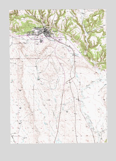
Newcastle, WY USGS Topographic Map
Click on map above to begin viewing in our Map Viewer.

This topographic map contains these locations and features:
Feature Name Type Latitude Longitude GNIS ID View Map
Black Hills National Forest Hells Canyon Ranger District Fire Engine CrewBuildingN43.8494°W104.1873°2673598View Map
Buck Pasture DrawValleyN43.8703°W104.1583°1586021View Map
Cambria CreekStreamN43.8489°W104.2208°1586288View Map
Cave Spring CanyonValleyN43.8605°W104.2052°1586473View Map
Cemetery CreekStreamN43.8500°W104.1827°1586519View Map
City of NewcastleCivilN43.8530°W104.1965°2411244View Map
Coal Mine CreekStreamN43.8236°W104.1388°1586833View Map
Dairy DrawValleyN43.8014°W104.1580°1587326View Map
Dey DrawValleyN43.8528°W104.1491°1587583View Map
Gertrude Burns Early Childhood SchoolSchoolN43.8547°W104.2049°1795672View Map
Gertrude Burns Intermediate SchoolSchoolN43.8547°W104.2049°1795673View Map
Greenwood CemeteryCemeteryN43.8519°W104.1949°1589133View Map
Hill View HeightsPopulated PlaceN43.8258°W104.1599°1853203View Map
Hill View Heights Census Designated PlaceCensusN43.8159°W104.1517°2408389View Map
Hilton DrawValleyN43.8516°W104.1769°1589585View Map
Johnson DrawValleyN43.8397°W104.1491°1590163View Map
KASL-AM (Newcastle)TowerN43.8464°W104.2130°1608809View Map
Left Fork Blacktail CreekStreamN43.7528°W104.1913°1590631View Map
Mondell Heights Odd Fellow/Rebekah Retirement HomeHospitalN43.8547°W104.2049°1794867View Map
Morris DrawValleyN43.8114°W104.1883°1591767View Map
NewcastlePopulated PlaceN43.8547°W104.2049°1592014View Map
Newcastle Ambulance ServiceBuildingN43.8540°W104.2011°2673544View Map
Newcastle High SchoolSchoolN43.8547°W104.2049°1795670View Map
Newcastle Middle SchoolSchoolN43.8547°W104.2049°1795671View Map
Newcastle Police DepartmentBuildingN43.8559°W104.2034°2752672View Map
Newcastle Post OfficePost OfficeN43.8551°W104.2027°1955533View Map
Newcastle Volunteer Fire DepartmentBuildingN43.8451°W104.2178°2673468View Map
Old Ridge CemeteryCemeteryN43.8357°W104.2281°2774541View Map
Salt CreekStreamN43.8072°W104.1372°1602697View Map
Shank DrawValleyN43.7733°W104.1911°1594155View Map
SpencerLocaleN43.7911°W104.1616°1597505View Map
Spencer DrawValleyN43.7614°W104.1324°1594778View Map
Spencer Number 2 DamDamN43.7833°W104.1272°1607096View Map
Spencer Number 2 ReservoirReservoirN43.7833°W104.1272°1607097View Map
Weston County Fire Protection District NewcastleBuildingN43.8498°W104.2412°2673490View Map
Weston County Health ServicesHospitalN43.8479°W104.1884°2673169View Map
Weston County Manor HospitalHospitalN43.8547°W104.2049°1794915View Map
Weston County Memorial Hospital (historical)HospitalN43.8547°W104.2049°1794890View Map

Note: Coordinates in the location and feature list above are referenced to NAD83 datum.


Copyright (C) 2008-2024 Ryan Niemi / Sunset Dynamics ... All Rights Reserved