TopoQuest Logo
Do you find TopoQuest useful?
Help keep TopoQuest running and adding new maps/features by donating!
Bitcoin:  19c7KJd3qBynnjoSw5npx9KScwjBe4ifkT
Litecoin:  LXs6TkuXGGXo1vDsWCkWVdjQX94eUKd6ui
Home View Maps Find Maps Find Places Resources & Links


Newell, Georgia Topographic Map

USGS Map Title: Newell, GA
USGS Map MRC: 30082H1
DRG (GeoTIFF) Download: o30082h1.tif


Neighboring USGS Topographic Map Quads:


  Fort Mudge, GA  
31082A2
 

  Winokur, GA  
31082A1
 

  Boons Lake, GA  
31081A8
 

  Double Lakes, GA  
30082H2
 

  Newell, GA  
30082H1
 

  Burnt Fort, GA  
30081H8
 

  Chase Prairie, GA  
30082G2
 

  Folkston, GA  
30082G1
 

  Boulogne, FL  
30081G8


Map MRC Location:

N31°
W83°
N31°
W82°
H8 H7 H6 H5 H4 H3 H2 H1
G8 G7 G6 G5 G4 G3 G2 G1
F8 F7 F6 F5 F4 F3 F2 F1
E8 E7 E6 E5 E4 E3 E2 E1
D8 D7 D6 D5 D4 D3 D2 D1
C8 C7 C6 C5 C4 C3 C2 C1
B8 B7 B6 B5 B4 B3 B2 B1
A8 A7 A6 A5 A4 A3 A2 A1
N30°
W83°
N30°
W82°

Newell, GA USGS 1:24K Topographic Map Preview:
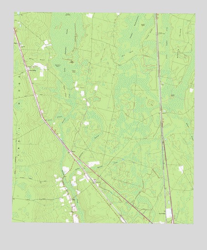
Newell, GA USGS Topographic Map
Click on map above to begin viewing in our Map Viewer.

This topographic map contains these locations and features:
Feature Name Type Latitude Longitude GNIS ID View Map
Burch SidingLocaleN30.8813°W82.0187°312041View Map
Caney BranchSwampN30.9361°W82.0892°312303View Map
Cedar HammocksIslandN30.9994°W82.0382°312484View Map
Charlton County Fire Department Station 3BuildingN30.9659°W82.1143°2603878View Map
Clay IslandIslandN30.9708°W82.0843°312703View Map
Cypress SidingPopulated PlaceN30.9658°W82.1151°331504View Map
Dark ThickSwampN30.9963°W82.0425°313312View Map
Grace ChapelChurchN30.8891°W82.0837°356068View Map
Little Spanish CreekStreamN30.8972°W82.0848°317205View Map
Macks IslandIslandN30.9530°W82.0901°317586View Map
MattoxPopulated PlaceN30.9177°W82.0846°332333View Map
Mays Bluff Branch (historical)SwampN30.9302°W82.0023°317824View Map
Melton BranchStreamN30.9713°W82.0990°318009View Map
NewellPopulated PlaceN30.9416°W82.0221°332496View Map
Petersons (historical)Populated PlaceN30.9725°W82.0262°357780View Map
Petty School (historical)SchoolN30.9344°W82.0776°357781View Map
Rabbit IslandIslandN30.9655°W82.0826°321261View Map
Rabbit IslandIslandN30.9933°W82.0354°321262View Map
Racepond ChurchChurchN30.9669°W82.1137°321274View Map
Sand Hill CemeteryCemeteryN30.9802°W82.1187°357790View Map
Sand Hill ChurchChurchN30.9802°W82.1193°322423View Map
Sandy IslandIslandN30.9811°W82.0818°322489View Map
Sweet Gum IslandIslandN30.9688°W82.0940°323811View Map
Trouble ValleyFlatN30.9883°W82.0310°324328View Map
Turkey IslandIslandN30.9505°W82.0157°324391View Map
UptonvillePopulated PlaceN30.8997°W82.0682°333314View Map
Warren IslandIslandN30.9925°W82.0087°324865View Map
Wilson HammockIslandN30.9988°W82.0873°325435View Map
Winding BranchSwampN30.9264°W82.0683°325444View Map
Winokur Lookout TowerTowerN30.9888°W82.0246°344385View Map

Note: Coordinates in the location and feature list above are referenced to NAD83 datum.


Copyright (C) 2008-2024 Ryan Niemi / Sunset Dynamics ... All Rights Reserved