TopoQuest Logo
Do you find TopoQuest useful?
Help keep TopoQuest running and adding new maps/features by donating!
Bitcoin:  19c7KJd3qBynnjoSw5npx9KScwjBe4ifkT
Litecoin:  LXs6TkuXGGXo1vDsWCkWVdjQX94eUKd6ui
Home View Maps Find Maps Find Places Resources & Links


Chase Prairie, Georgia Topographic Map

USGS Map Title: Chase Prairie, GA
USGS Map MRC: 30082G2
DRG (GeoTIFF) Download: o30082g2.tif


Neighboring USGS Topographic Map Quads:


  Dinner Pond, GA  
30082H3
 

  Double Lakes, GA  
30082H2
 

  Newell, GA  
30082H1
 

  Billys Island, GA  
30082G3
 

  Chase Prairie, GA  
30082G2
 

  Folkston, GA  
30082G1
 

  Blackjack Island, GA  
30082F3
 

  Chesser Island, GA  
30082F2
 

  Toledo, GA  
30082F1


Map MRC Location:

N31°
W83°
N31°
W82°
H8 H7 H6 H5 H4 H3 H2 H1
G8 G7 G6 G5 G4 G3 G2 G1
F8 F7 F6 F5 F4 F3 F2 F1
E8 E7 E6 E5 E4 E3 E2 E1
D8 D7 D6 D5 D4 D3 D2 D1
C8 C7 C6 C5 C4 C3 C2 C1
B8 B7 B6 B5 B4 B3 B2 B1
A8 A7 A6 A5 A4 A3 A2 A1
N30°
W83°
N30°
W82°

Chase Prairie, GA USGS 1:24K Topographic Map Preview:
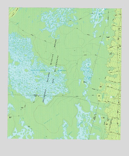
Chase Prairie, GA USGS Topographic Map
Click on map above to begin viewing in our Map Viewer.

This topographic map contains these locations and features:
Feature Name Type Latitude Longitude GNIS ID View Map
Big LakeLakeN30.8388°W82.2448°357741View Map
Big LakeLakeN30.7711°W82.1662°1671295View Map
Boggy LakeLakeN30.8152°W82.1623°311621View Map
Bugaboo LandingLocaleN30.7791°W82.2343°331277View Map
Bush LakeLakeN30.8213°W82.1621°312086View Map
Camphose LakeLakeN30.8200°W82.1640°312273View Map
Cedar HammockIslandN30.8050°W82.1668°312479View Map
Cedar Hammock CanalCanalN30.7541°W82.1904°312482View Map
Charlton CountyCivilN30.7817°W82.1377°357747View Map
Chase PrairieSwampN30.8161°W82.2262°312581View Map
Christie LakeLakeN30.8177°W82.1626°312659View Map
Christie PrairieSwampN30.8111°W82.1635°312660View Map
Coffee Bay Rest ShelterLocaleN30.7616°W82.2273°312795View Map
Dan Dunkins LakeLakeN30.7661°W82.1601°1671296View Map
Davis Boat LandingLocaleN30.7861°W82.1507°331518View Map
Davis PondReservoirN30.7900°W82.1357°313360View Map
Davis School (historical)SchoolN30.7886°W82.1318°357754View Map
Double LakesLakeN30.8250°W82.1657°357755View Map
Double O BaySwampN30.7686°W82.2007°313580View Map
Duck IslandIslandN30.7902°W82.1485°313697View Map
Eagle Nest LakeLakeN30.8638°W82.1507°313759View Map
Fishingpole LakeLakeN30.8016°W82.2087°357760View Map
Galepost LakeLakeN30.8052°W82.2168°357765View Map
Half Moon LakeLakeN30.8744°W82.1446°315021View Map
House LakeLakeN30.8465°W82.1946°357768View Map
Indian IslandIslandN30.8022°W82.1460°315906View Map
Jack LakeLakeN30.7561°W82.1635°1671297View Map
Jack LakeLakeN30.8166°W82.1615°315983View Map
Little Double LakesLakeN30.8680°W82.1501°317058View Map
Lloyd IslandIslandN30.7713°W82.1451°317269View Map
Long LakeLakeN30.8088°W82.2437°357772View Map
Long LakeLakeN30.7747°W82.1690°1671298View Map
Mandy LakeLakeN30.7741°W82.1607°1671299View Map
McDonald IslandIslandN30.8461°W82.1398°317899View Map
Mizell PrairieSwampN30.7611°W82.1718°318355View Map
Outside BaySwampN30.7975°W82.1485°357777View Map
Silver HillPopulated PlaceN30.8380°W82.1262°333055View Map
Sometime HoleLakeN30.8121°W82.2217°357793View Map
Suwannee CanalCanalN30.7838°W82.2360°356571View Map
Territory PrairieSwampN30.8658°W82.1937°324013View Map
Walter LakesLakeN30.7775°W82.1676°1671300View Map

Note: Coordinates in the location and feature list above are referenced to NAD83 datum.


Copyright (C) 2008-2025 Ryan Niemi / Sunset Dynamics ... All Rights Reserved