TopoQuest Logo
Do you find TopoQuest useful?
Help keep TopoQuest running and adding new maps/features by donating!
Bitcoin:  19c7KJd3qBynnjoSw5npx9KScwjBe4ifkT
Litecoin:  LXs6TkuXGGXo1vDsWCkWVdjQX94eUKd6ui
Home View Maps Find Maps Find Places Resources & Links


Newhope, Arkansas Topographic Map

USGS Map Title: Newhope, AR
USGS Map MRC: 34093B8
DRG (GeoTIFF) Download: o34093b8.tif


Neighboring USGS Topographic Map Quads:


  Umpire, AR  
34094C1
 

  Athens, AR  
34093C8
 

  Langley, AR  
34093C7
 

  Dierks Dam, AR  
34094B1
 

  Newhope, AR  
34093B8
 

  Center Point NE, AR  
34093B7
 

  Dierks, AR  
34094A1
 

  Center Point, AR  
34093A8
 

  Nathan, AR  
34093A7


Map MRC Location:

N35°
W94°
N35°
W93°
H8 H7 H6 H5 H4 H3 H2 H1
G8 G7 G6 G5 G4 G3 G2 G1
F8 F7 F6 F5 F4 F3 F2 F1
E8 E7 E6 E5 E4 E3 E2 E1
D8 D7 D6 D5 D4 D3 D2 D1
C8 C7 C6 C5 C4 C3 C2 C1
B8 B7 B6 B5 B4 B3 B2 B1
A8 A7 A6 A5 A4 A3 A2 A1
N34°
W94°
N34°
W93°

Newhope, AR USGS 1:24K Topographic Map Preview:
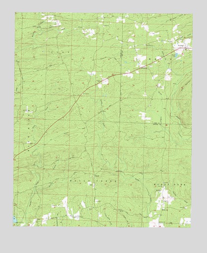
Newhope, AR USGS Topographic Map
Click on map above to begin viewing in our Map Viewer.

This topographic map contains these locations and features:
Feature Name Type Latitude Longitude GNIS ID View Map
Antioch CemeteryCemeteryN34.2104°W93.9399°45885View Map
Antioch Church (historical)ChurchN34.2101°W93.9391°62522View Map
Bandy CreekStreamN34.1776°W93.8819°46071View Map
Bissell (historical)Populated PlaceN34.2473°W93.9377°62534View Map
Blackwood CemeteryCemeteryN34.1465°W93.8957°46700View Map
GrandfieldPopulated PlaceN34.2184°W93.9119°57838View Map
Green PlainsPopulated PlaceN34.1307°W93.9524°62589View Map
Green Plains ChurchChurchN34.1309°W93.9569°49645View Map
Green Plains School (historical)SchoolN34.1309°W93.9566°62590View Map
Harmony CemeteryCemeteryN34.2029°W93.9521°49865View Map
Harmony Church (historical)ChurchN34.2018°W93.9552°62592View Map
Hattie (historical)Populated PlaceN34.1418°W93.9946°64902View Map
Henry CemeteryCemeteryN34.1734°W93.9891°50018View Map
Kesterson CemeteryCemeteryN34.1282°W93.8971°50826View Map
Liberty CemeteryCemeteryN34.2076°W93.9002°51088View Map
Long CreekStreamN34.2390°W93.9810°51420View Map
Muddy ForkPopulated PlaceN34.1359°W93.8949°77776View Map
New Hope Fire DepartmentBuildingN34.2297°W93.8796°2116848View Map
NewhopePopulated PlaceN34.2304°W93.8802°77844View Map
Newhope Post OfficePost OfficeN34.2295°W93.8844°84273View Map
Pleasant Grove ChurchChurchN34.2321°W93.9080°53539View Map
Slip-Up and Hitch (historical)Populated PlaceN34.2459°W93.9538°62682View Map
Township of ClayCivilN34.2357°W93.9680°66678View Map
Trout BranchStreamN34.1465°W93.9849°78586View Map
Water Can CrossingLocaleN34.1557°W93.9430°58834View Map

Note: Coordinates in the location and feature list above are referenced to NAD83 datum.


Copyright (C) 2008-2024 Ryan Niemi / Sunset Dynamics ... All Rights Reserved