TopoQuest Logo
Do you find TopoQuest useful?
Help keep TopoQuest running and adding new maps/features by donating!
Bitcoin:  19c7KJd3qBynnjoSw5npx9KScwjBe4ifkT
Litecoin:  LXs6TkuXGGXo1vDsWCkWVdjQX94eUKd6ui
Home View Maps Find Maps Find Places Resources & Links


Langley, Arkansas Topographic Map

USGS Map Title: Langley, AR
USGS Map MRC: 34093C7
DRG (GeoTIFF) Download: o34093c7.tif


Neighboring USGS Topographic Map Quads:


  Big Fork, AR  
34093D8
 

  Polk Creek Mountain, AR  
34093D7
 

  Norman, AR  
34093D6
 

  Athens, AR  
34093C8
 

  Langley, AR  
34093C7
 

  Lodi, AR  
34093C6
 

  Newhope, AR  
34093B8
 

  Center Point NE, AR  
34093B7
 

  Narrows Dam, AR  
34093B6


Map MRC Location:

N35°
W94°
N35°
W93°
H8 H7 H6 H5 H4 H3 H2 H1
G8 G7 G6 G5 G4 G3 G2 G1
F8 F7 F6 F5 F4 F3 F2 F1
E8 E7 E6 E5 E4 E3 E2 E1
D8 D7 D6 D5 D4 D3 D2 D1
C8 C7 C6 C5 C4 C3 C2 C1
B8 B7 B6 B5 B4 B3 B2 B1
A8 A7 A6 A5 A4 A3 A2 A1
N34°
W94°
N34°
W93°

Langley, AR USGS 1:24K Topographic Map Preview:
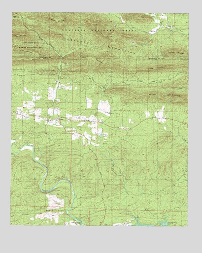
Langley, AR USGS Topographic Map
Click on map above to begin viewing in our Map Viewer.

This topographic map contains these locations and features:
Feature Name Type Latitude Longitude GNIS ID View Map
AlbertPopulated PlaceN34.3712°W93.8746°70416View Map
Back ValleyValleyN34.3648°W93.7719°70483View Map
Beardon MountainSummitN34.3529°W93.7613°56902View Map
Blocker CreekStreamN34.2876°W93.8552°70725View Map
Brooks MountainSummitN34.3432°W93.7624°70836View Map
Brooks ValleyValleyN34.3265°W93.8110°70837View Map
Cossatot MountainsRangeN34.3709°W93.8466°66988View Map
Dempsey Cog Bur Barite MineMineN34.3568°W93.7866°74435View Map
Fancy HillLocaleN34.3665°W93.7641°76907View Map
Fancy Hill CemeteryCemeteryN34.3729°W93.7691°63482View Map
Fancy Hill MountainSummitN34.3723°W93.7877°71590View Map
Fancy Hill School (historical)SchoolN34.3709°W93.7646°63483View Map
Hogpen CreekStreamN34.3265°W93.8119°72038View Map
Hogpen MountainSummitN34.3476°W93.8188°72040View Map
Hurricane CreekStreamN34.2593°W93.8335°72120View Map
LangleyPopulated PlaceN34.3129°W93.8419°77445View Map
Langley Post OfficePost OfficeN34.3128°W93.8413°84271View Map
Langley Volunteer Fire DepartmentBuildingN34.3127°W93.8415°2625419View Map
Little Blocker CreekStreamN34.3090°W93.8499°72371View Map
McKnight Barite MineMineN34.3682°W93.8044°74434View Map
Paul MountainSummitN34.3501°W93.8563°73019View Map
Pryor MountainSummitN34.3615°W93.8707°78114View Map
Redland GapGapN34.3270°W93.7649°73263View Map
Redland MountainSummitN34.3257°W93.7566°73264View Map
Sugar CreekStreamN34.2559°W93.8705°73751View Map
Township of MountainCivilN34.3113°W93.8470°68965View Map

Note: Coordinates in the location and feature list above are referenced to NAD83 datum.


Copyright (C) 2008-2024 Ryan Niemi / Sunset Dynamics ... All Rights Reserved