TopoQuest Logo
Do you find TopoQuest useful?
Help keep TopoQuest running and adding new maps/features by donating!
Bitcoin:  19c7KJd3qBynnjoSw5npx9KScwjBe4ifkT
Litecoin:  LXs6TkuXGGXo1vDsWCkWVdjQX94eUKd6ui
Home View Maps Find Maps Find Places Resources & Links


Newport Center, Vermont Topographic Map

USGS Map Title: Newport Center, VT
USGS Map MRC: 44072H3
DRG (GeoTIFF) Download: o44072h3.tif


Neighboring USGS Topographic Map Quads:


  North Troy, VT  
44072H4
 

  Newport Center, VT  
44072H3
 

  Newport, VT  
44072H2
 

  Lowell, VT  
44072G4
 

  Irasburg, VT  
44072G3
 

  Orleans, VT  
44072G2


Map MRC Location:

N45°
W73°
N45°
W72°
H8 H7 H6 H5 H4 H3 H2 H1
G8 G7 G6 G5 G4 G3 G2 G1
F8 F7 F6 F5 F4 F3 F2 F1
E8 E7 E6 E5 E4 E3 E2 E1
D8 D7 D6 D5 D4 D3 D2 D1
C8 C7 C6 C5 C4 C3 C2 C1
B8 B7 B6 B5 B4 B3 B2 B1
A8 A7 A6 A5 A4 A3 A2 A1
N44°
W73°
N44°
W72°

Newport Center, VT USGS 1:24K Topographic Map Preview:
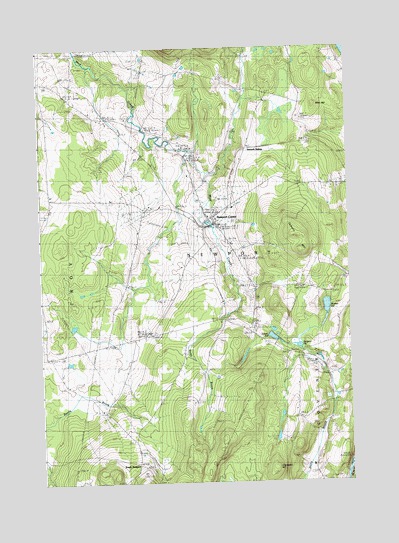
Newport Center, VT USGS Topographic Map
Click on map above to begin viewing in our Map Viewer.

This topographic map contains these locations and features:
Feature Name Type Latitude Longitude GNIS ID View Map
Allen HillSummitN44.9839°W72.2629°1456148View Map
Brown SchoolSchoolN44.9217°W72.2995°1456601View Map
Burington SchoolSchoolN44.9159°W72.3368°1456658View Map
Cleveland HillSummitN44.8792°W72.2832°1456920View Map
Coburn HillSummitN44.9420°W72.2690°1456948View Map
Dunn BrookStreamN44.9253°W72.2965°1457216View Map
Farrar SchoolSchoolN44.9870°W72.2820°1457412View Map
Newport CenterPopulated PlaceN44.9509°W72.3065°1458682View Map
Newport Center CemeteryCemeteryN44.9228°W72.2917°1456819View Map
Newport Center Census Designated PlaceCensusN44.9509°W72.3043°2586643View Map
Newport Center Post OfficePost OfficeN44.9512°W72.3066°1920071View Map
Newport Town Elementary SchoolSchoolN44.9517°W72.3063°1920075View Map
Sargent PondReservoirN44.9141°W72.2708°1459377View Map
Smith PondReservoirN44.9167°W72.2813°1459544View Map
South NewportPopulated PlaceN44.8803°W72.3357°1460455View Map
Summit SidingLocaleN44.9714°W72.2907°1459777View Map
Town of NewportCivilN44.9360°W72.3042°1462162View Map
Walker PondReservoirN44.9255°W72.2593°1460048View Map
West Hill SchoolSchoolN44.9484°W72.3334°1460154View Map

Note: Coordinates in the location and feature list above are referenced to NAD83 datum.


Copyright (C) 2008-2024 Ryan Niemi / Sunset Dynamics ... All Rights Reserved