TopoQuest Logo
Do you find TopoQuest useful?
Help keep TopoQuest running and adding new maps/features by donating!
Bitcoin:  19c7KJd3qBynnjoSw5npx9KScwjBe4ifkT
Litecoin:  LXs6TkuXGGXo1vDsWCkWVdjQX94eUKd6ui
Home View Maps Find Maps Find Places Resources & Links


Irasburg, Vermont Topographic Map

USGS Map Title: Irasburg, VT
USGS Map MRC: 44072G3
DRG (GeoTIFF) Download: o44072g3.tif


Neighboring USGS Topographic Map Quads:


  North Troy, VT  
44072H4
 

  Newport Center, VT  
44072H3
 

  Newport, VT  
44072H2
 

  Lowell, VT  
44072G4
 

  Irasburg, VT  
44072G3
 

  Orleans, VT  
44072G2
 

  Albany, VT  
44072F4
 

  Craftsbury, VT  
44072F3
 

  Crystal Lake, VT  
44072F2


Map MRC Location:

N45°
W73°
N45°
W72°
H8 H7 H6 H5 H4 H3 H2 H1
G8 G7 G6 G5 G4 G3 G2 G1
F8 F7 F6 F5 F4 F3 F2 F1
E8 E7 E6 E5 E4 E3 E2 E1
D8 D7 D6 D5 D4 D3 D2 D1
C8 C7 C6 C5 C4 C3 C2 C1
B8 B7 B6 B5 B4 B3 B2 B1
A8 A7 A6 A5 A4 A3 A2 A1
N44°
W73°
N44°
W72°

Irasburg, VT USGS 1:24K Topographic Map Preview:
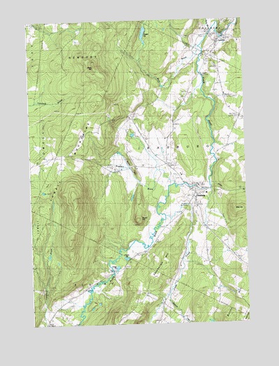
Irasburg, VT USGS Topographic Map
Click on map above to begin viewing in our Map Viewer.

This topographic map contains these locations and features:
Feature Name Type Latitude Longitude GNIS ID View Map
Allen BrookStreamN44.8075°W72.2712°1456144View Map
Allen HillSummitN44.7953°W72.2559°1456147View Map
Beaver BrookStreamN44.7500°W72.2840°1456341View Map
Black HillSummitN44.8575°W72.3362°1456445View Map
Brighton BrookStreamN44.8067°W72.2934°1456569View Map
Brighton SchoolSchoolN44.8125°W72.3237°1456570View Map
Brown SchoolSchoolN44.7592°W72.3582°1456600View Map
Burton HillSummitN44.7503°W72.2645°1456686View Map
Chamberlain HillSummitN44.7678°W72.3034°1456838View Map
Chamberlain Hill CemeteryCemeteryN44.7621°W72.3090°1919958View Map
CoventryPopulated PlaceN44.8656°W72.2648°1457029View Map
Coventry Census Designated PlaceCensusN44.8660°W72.2678°2586625View Map
Coventry Post OfficePost OfficeN44.8663°W72.2640°1919960View Map
Coventry Village SchoolSchoolN44.8626°W72.2647°1919961View Map
Federated Protestant ChurchChurchN44.8020°W72.2793°1920000View Map
Grace Brethren ChurchChurchN44.8656°W72.2643°1920008View Map
Griggs PondReservoirN44.7731°W72.3253°1457653View Map
Hovey CemeteryCemeteryN44.7601°W72.3540°1920028View Map
IrasburgPopulated PlaceN44.8034°W72.2795°1457972View Map
Irasburg CemeteryCemeteryN44.8117°W72.2907°1920034View Map
Irasburg Census Designated PlaceCensusN44.8003°W72.2850°2586641View Map
Irasburg Fire DepartmentBuildingN44.8036°W72.2760°2121423View Map
Irasburg Post OfficePost OfficeN44.8023°W72.2785°1920035View Map
Irasburg SquareParkN44.8028°W72.2793°1920036View Map
Irasburg Village SchoolSchoolN44.8036°W72.2728°1920037View Map
Kidder PondReservoirN44.8693°W72.3073°1458083View Map
Leach Public LibraryBuildingN44.8062°W72.2793°1920047View Map
Lords CreekStreamN44.7948°W72.2979°1458288View Map
Orne Covered BridgeBridgeN44.8609°W72.2818°1920100View Map
Potters PondReservoirN44.7771°W72.3198°1459063View Map
Round HillSummitN44.7931°W72.3134°1459251View Map
Saint John Vianny CemeteryCemeteryN44.8093°W72.2889°1920110View Map
Stony BrookStreamN44.8709°W72.2682°1459737View Map
Stony HillSummitN44.8175°W72.3173°1459740View Map
Town of IrasburgCivilN44.8143°W72.2841°1462124View Map
United Church of IrasburgChurchN44.8020°W72.2793°1920130View Map
Village CemeteryCemeteryN44.8690°W72.2553°1920135View Map
Ware BrookStreamN44.8637°W72.2754°1460064View Map

Note: Coordinates in the location and feature list above are referenced to NAD83 datum.


Copyright (C) 2008-2024 Ryan Niemi / Sunset Dynamics ... All Rights Reserved