TopoQuest Logo
Do you find TopoQuest useful?
Help keep TopoQuest running and adding new maps/features by donating!
Bitcoin:  19c7KJd3qBynnjoSw5npx9KScwjBe4ifkT
Litecoin:  LXs6TkuXGGXo1vDsWCkWVdjQX94eUKd6ui
Home View Maps Find Maps Find Places Resources & Links


Nogales, Arizona Topographic Map

USGS Map Title: Nogales, AZ
USGS Map MRC: 31110C8
DRG (GeoTIFF) Download: o31110c8.tif


Neighboring USGS Topographic Map Quads:


  Pena Blanca Lake, AZ  
31111D1
 

  Rio Rico, AZ  
31110D8
 

  Cumero Canyon, AZ  
31110D7
 

  Pajarito Peak, AZ  
31111C1
 

  Nogales, AZ  
31110C8
 

  Kino Springs, AZ  
31110C7


Map MRC Location:

N32°
W111°
N32°
W110°
H8 H7 H6 H5 H4 H3 H2 H1
G8 G7 G6 G5 G4 G3 G2 G1
F8 F7 F6 F5 F4 F3 F2 F1
E8 E7 E6 E5 E4 E3 E2 E1
D8 D7 D6 D5 D4 D3 D2 D1
C8 C7 C6 C5 C4 C3 C2 C1
B8 B7 B6 B5 B4 B3 B2 B1
A8 A7 A6 A5 A4 A3 A2 A1
N31°
W111°
N31°
W110°

Nogales, AZ USGS 1:24K Topographic Map Preview:
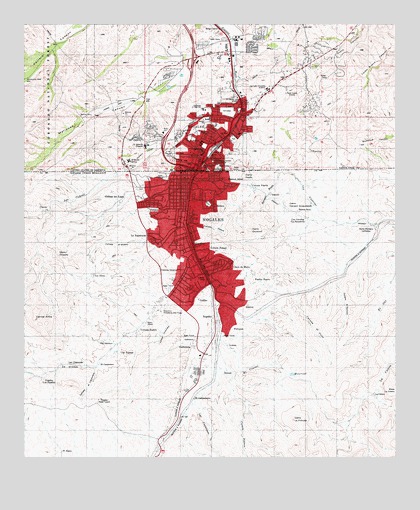
Nogales, AZ USGS Topographic Map
Click on map above to begin viewing in our Map Viewer.

This topographic map contains these locations and features:
Feature Name Type Latitude Longitude GNIS ID View Map
A J Mitchell Elementary SchoolSchoolN31.3477°W110.9392°36729View Map
Abundant Life Assembly of GodChurchN31.3562°W110.9184°2623012View Map
Carondelet Holy Cross HospitalHospitalN31.3399°W110.9597°2622851View Map
Challenger Elementary SchoolSchoolN31.3721°W110.9145°2544839View Map
City of NogalesCivilN31.3625°W110.9337°2411260View Map
Cochise College Nogales Santa Cruz CenterSchoolN31.3687°W110.9326°2544855View Map
Coronado Elementary SchoolSchoolN31.3742°W110.9617°2544878View Map
Crawford HillSummitN31.3359°W110.9484°36600View Map
El Mesias United Methodist ChurchChurchN31.3652°W110.9539°2623415View Map
Elm Street SchoolSchoolN31.3373°W110.9409°36625View Map
Emmanuel Baptist ChurchChurchN31.3478°W110.9272°2623086View Map
Ephriah CanyonValleyN31.3470°W110.9309°28912View Map
First Baptist Church of NogalesChurchN31.3682°W110.9520°2623427View Map
Ione Marcus Gordon Memorial ParkCemeteryN31.3354°W110.9373°36663View Map
KFBR-AM (Nogales)TowerN31.3526°W110.9293°43229View Map
Kingdom Hall of Jehovahs Witnesses Spanish CongregationChurchN31.3573°W110.9629°2623485View Map
Kino ParkParkN31.3507°W110.9265°36681View Map
Lincoln Elementary SchoolSchoolN31.3434°W110.9282°36690View Map
Lourdes Catholic SchoolSchoolN31.3570°W110.9194°32583View Map
Mariposa CanyonValleyN31.3698°W110.9345°31514View Map
Mariposa Land Port of EntryLocaleN31.3343°W110.9665°2622903View Map
Mary L Welty Elementary SchoolSchoolN31.3440°W110.9536°36716View Map
Mexicayotl AcademySchoolN31.3479°W110.9276°2543731View Map
Nasib Karam ParkParkN31.3348°W110.9406°36740View Map
NogalesPopulated PlaceN31.3404°W110.9343°32336View Map
Nogales City HallBuildingN31.3460°W110.9319°2623625View Map
Nogales District Ranger OfficeLocaleN31.3737°W110.9351°45618View Map
Nogales Fire Department Station 1BuildingN31.3454°W110.9315°2622534View Map
Nogales High SchoolSchoolN31.3675°W110.9496°36745View Map
Nogales Police DepartmentBuildingN31.3459°W110.9318°2622619View Map
Nogales Post OfficePost OfficeN31.3375°W110.9373°2622638View Map
Pierson Vocational High SchoolSchoolN31.3407°W110.9408°2544770View Map
Pinnacle Charter High SchoolSchoolN31.3691°W110.9326°2544857View Map
Sacred Heart Catholic SchoolSchoolN31.3380°W110.9409°36826View Map
Sacred Heart ChurchChurchN31.3376°W110.9409°2623511View Map
Santa Cruz County Sheriff's OfficeBuildingN31.3720°W110.9370°2622618View Map
Wade Carpenter Middle SchoolSchoolN31.3506°W110.9402°36578View Map

Note: Coordinates in the location and feature list above are referenced to NAD83 datum.


Copyright (C) 2008-2024 Ryan Niemi / Sunset Dynamics ... All Rights Reserved