TopoQuest Logo
Do you find TopoQuest useful?
Help keep TopoQuest running and adding new maps/features by donating!
Bitcoin:  19c7KJd3qBynnjoSw5npx9KScwjBe4ifkT
Litecoin:  LXs6TkuXGGXo1vDsWCkWVdjQX94eUKd6ui
Home View Maps Find Maps Find Places Resources & Links


Cumero Canyon, Arizona Topographic Map

USGS Map Title: Cumero Canyon, AZ
USGS Map MRC: 31110D7
DRG (GeoTIFF) Download: o31110d7.tif


Neighboring USGS Topographic Map Quads:


  San Cayetano Mountains, AZ  
31110E8
 

  Patagonia, AZ  
31110E7
 

  Mount Hughes, AZ  
31110E6
 

  Rio Rico, AZ  
31110D8
 

  Cumero Canyon, AZ  
31110D7
 

  Harshaw, AZ  
31110D6
 

  Nogales, AZ  
31110C8
 

  Kino Springs, AZ  
31110C7
 

  Duquesne, AZ  
31110C6


Map MRC Location:

N32°
W111°
N32°
W110°
H8 H7 H6 H5 H4 H3 H2 H1
G8 G7 G6 G5 G4 G3 G2 G1
F8 F7 F6 F5 F4 F3 F2 F1
E8 E7 E6 E5 E4 E3 E2 E1
D8 D7 D6 D5 D4 D3 D2 D1
C8 C7 C6 C5 C4 C3 C2 C1
B8 B7 B6 B5 B4 B3 B2 B1
A8 A7 A6 A5 A4 A3 A2 A1
N31°
W111°
N31°
W110°

Cumero Canyon, AZ USGS 1:24K Topographic Map Preview:
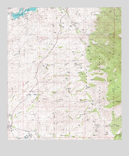
Cumero Canyon, AZ USGS Topographic Map
Click on map above to begin viewing in our Map Viewer.

This topographic map contains these locations and features:
Feature Name Type Latitude Longitude GNIS ID View Map
Alisos WellWellN31.3793°W110.7526°36518View Map
Ash CanyonValleyN31.4956°W110.8618°25777View Map
Barriles TankReservoirN31.4936°W110.7817°36537View Map
Basin SpringSpringN31.4218°W110.7595°36538View Map
Bennett MineMineN31.3829°W110.7790°1956076View Map
Beyerville Census Designated PlaceCensusN31.3920°W110.8749°2582738View Map
Big Lead MineMineN31.3932°W110.7890°1956074View Map
Blue Eagle MineMineN31.4920°W110.7565°1956091View Map
Buena Vista LakeLakeN31.3793°W110.8530°36563View Map
Buena Vista MineMineN31.3804°W110.7684°1956078View Map
Caņada de la PalomaValleyN31.3965°W110.8709°27237View Map
Chango TankReservoirN31.4760°W110.8220°36582View Map
Circle Z RanchLocaleN31.4990°W110.8131°36590View Map
Cox GulchValleyN31.4740°W110.7876°28105View Map
Crescent SpringSpringN31.3793°W110.7520°1956096View Map
Denver MineMineN31.4509°W110.7829°1956085View Map
Domino MineMineN31.4720°W110.7884°36610View Map
Douglas WellWellN31.3993°W110.7926°36614View Map
European MineMineN31.4643°W110.7681°1956088View Map
Flowing WellWellN31.4698°W110.7819°2680414View Map
Flux MineMineN31.4890°W110.7554°1956090View Map
Flux SpringSpringN31.4875°W110.7522°2680413View Map
Fresno CanyonValleyN31.4435°W110.8321°2727270View Map
G Castro (historical)LocaleN31.4543°W110.8381°36637View Map
Golden Rose MineMineN31.3887°W110.7759°1956075View Map
Grande TankReservoirN31.4571°W110.8023°36641View Map
Gross MineMineN31.3993°W110.7920°1956073View Map
Guajalote PeakSpringN31.4109°W110.7518°1956094View Map
Hangmans CanyonValleyN31.4968°W110.8587°29720View Map
Isabella MineMineN31.4093°W110.7823°43108View Map
Jarillas MineMineN31.4393°W110.8098°1956081View Map
Jarillas TankReservoirN31.4332°W110.8093°36667View Map
Javelina WellWellN31.4120°W110.7931°36669View Map
Jim DamDamN31.3993°W110.8448°36671View Map
King MineMineN31.3823°W110.7673°1956077View Map
Kino SpringsSpringN31.3771°W110.8646°36682View Map
Kino Springs DamDamN31.3770°W110.8656°36684View Map
Kino Springs LakeReservoirN31.3777°W110.8651°36685View Map
Lake Patagonia CampgroundLocaleN31.4954°W110.8554°45013View Map
Little Red SchoolhouseSchoolN31.3878°W110.8721°34067View Map
Lookout MineMineN31.4740°W110.7887°1956092View Map
Los Pajaros Verdes TankReservoirN31.4254°W110.7902°36763View Map
Lower Paloma DamDamN31.4232°W110.8095°36705View Map
Lower Providencia TanksReservoirN31.3788°W110.8188°36707View Map
Maggies CanyonValleyN31.4801°W110.8001°31443View Map
Maggies MineMineN31.4604°W110.7881°1956086View Map
Maggies TankReservoirN31.4603°W110.7886°2680415View Map
Maggies WellWellN31.4634°W110.7884°31444View Map
Marche MineMineN31.3882°W110.7556°1956079View Map
Mary Kane CanyonValleyN31.4998°W110.8059°31553View Map
Minnesota MineMineN31.3882°W110.7668°36728View Map
National MineMineN31.4120°W110.7834°1956071View Map
Nettle TankReservoirN31.4824°W110.8049°36743View Map
Nogales International AirportAirportN31.4169°W110.8509°45424View Map
O'Maras MineMineN31.4312°W110.7643°1956080View Map
Paja Verde SpringSpringN31.4315°W110.7845°1956093View Map
Paja Verde TankReservoirN31.4363°W110.7951°36762View Map
Palmetto MineMineN31.4459°W110.8001°1956082View Map
Paloma WellWellN31.4195°W110.8240°36765View Map
Pasture WellWellN31.4815°W110.8156°36769View Map
Patagonia LakeLakeN31.4950°W110.8594°36770View Map
Patagonia Lake State ParkParkN31.4918°W110.8501°36771View Map
Proto CanyonValleyN31.3873°W110.8745°33214View Map
Providencia CanyonValleyN31.3776°W110.8131°33215View Map
Providencia StorageReservoirN31.3786°W110.7822°2680410View Map
Providencia WellWellN31.3795°W110.7818°36792View Map
Robert E Lee MineMineN31.4501°W110.8031°1956083View Map
Sand CanyonValleyN31.4987°W110.8201°34031View Map
Sandy TankReservoirN31.3888°W110.7985°36831View Map
Sanfords (historical)LocaleN31.4973°W110.8426°36832View Map
Shamrock MineMineN31.4054°W110.7848°1956072View Map
Shannon SpringSpringN31.3884°W110.7681°1956095View Map
Soldier BasinBasinN31.4229°W110.7545°34610View Map
Sonoita MineMineN31.4548°W110.7920°1956084View Map
Stacey LakeLakeN31.3769°W110.8557°36855View Map
T 4 RanchLocaleN31.4529°W110.8354°36861View Map
Tascala CanyonValleyN31.4087°W110.8451°35156View Map
Tascala TankReservoirN31.4128°W110.8197°35157View Map
Three R CanyonValleyN31.4990°W110.8148°35295View Map
Three R MineMineN31.4743°W110.7643°1956089View Map
Three R TankReservoirN31.4777°W110.7937°36863View Map
Tres de Mayo TankReservoirN31.4437°W110.7937°36874View Map
Tres de Mayo WellWellN31.4457°W110.8001°36875View Map
Ventura MineMineN31.4573°W110.7643°1956087View Map
Wild Hog CanyonValleyN31.3809°W110.8348°36162View Map
Yerba Buena CanyonValleyN31.3784°W110.8654°36477View Map

Note: Coordinates in the location and feature list above are referenced to NAD83 datum.


Copyright (C) 2008-2024 Ryan Niemi / Sunset Dynamics ... All Rights Reserved