TopoQuest Logo
Do you find TopoQuest useful?
Help keep TopoQuest running and adding new maps/features by donating!
Bitcoin:  19c7KJd3qBynnjoSw5npx9KScwjBe4ifkT
Litecoin:  LXs6TkuXGGXo1vDsWCkWVdjQX94eUKd6ui
Home View Maps Find Maps Find Places Resources & Links


Rio Rico, Arizona Topographic Map

USGS Map Title: Rio Rico, AZ
USGS Map MRC: 31110D8
DRG (GeoTIFF) Download: o31110d8.tif


Neighboring USGS Topographic Map Quads:


  Tubac, AZ  
31111E1
 

  San Cayetano Mountains, AZ  
31110E8
 

  Patagonia, AZ  
31110E7
 

  Pena Blanca Lake, AZ  
31111D1
 

  Rio Rico, AZ  
31110D8
 

  Cumero Canyon, AZ  
31110D7
 

  Pajarito Peak, AZ  
31111C1
 

  Nogales, AZ  
31110C8
 

  Kino Springs, AZ  
31110C7


Map MRC Location:

N32°
W111°
N32°
W110°
H8 H7 H6 H5 H4 H3 H2 H1
G8 G7 G6 G5 G4 G3 G2 G1
F8 F7 F6 F5 F4 F3 F2 F1
E8 E7 E6 E5 E4 E3 E2 E1
D8 D7 D6 D5 D4 D3 D2 D1
C8 C7 C6 C5 C4 C3 C2 C1
B8 B7 B6 B5 B4 B3 B2 B1
A8 A7 A6 A5 A4 A3 A2 A1
N31°
W111°
N31°
W110°

Rio Rico, AZ USGS 1:24K Topographic Map Preview:
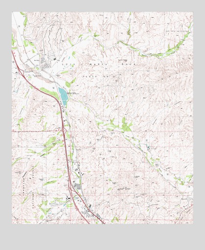
Rio Rico, AZ USGS Topographic Map
Click on map above to begin viewing in our Map Viewer.

This topographic map contains these locations and features:
Feature Name Type Latitude Longitude GNIS ID View Map
Agua Frio (historical)LocaleN31.4834°W110.9993°40528View Map
Alamo CanyonValleyN31.4114°W110.9590°25559View Map
Bellotosa CanyonValleyN31.4158°W110.9829°26144View Map
Benedict (historical)LocaleN31.3779°W110.9501°42694View Map
BeyervillePopulated PlaceN31.3904°W110.8784°36551View Map
Burro CanyonValleyN31.4174°W110.9060°27042View Map
CalabasasPopulated PlaceN31.4673°W110.9754°27169View Map
Calabasas CanyonValleyN31.4619°W110.9849°27170View Map
Calabasas Hotel (historical)LocaleN31.4634°W110.9695°36569View Map
Calabasas Private Land Grant (historical)CivilN31.4065°W110.9173°36571View Map
Calabasas SchoolSchoolN31.4379°W110.9682°2543732View Map
Calabasas Store (historical)LocaleN31.4501°W110.9698°36572View Map
Caralampi CanyonValleyN31.4646°W110.9899°27282View Map
Coatimundi Middle SchoolSchoolN31.4665°W110.9747°2544872View Map
Cottonwood CanyonValleyN31.3938°W110.8829°36594View Map
Cowhead TankReservoirN31.4015°W110.9788°36595View Map
Cuates ButteSummitN31.4712°W110.9225°28205View Map
Cumero CanyonValleyN31.3993°W110.8792°27837View Map
Desert Shadows Middle SchoolSchoolN31.4025°W110.9696°2544838View Map
Dura MineMineN31.3915°W110.9131°1956068View Map
Fort Mason (historical)LocaleN31.4570°W110.9695°42696View Map
Fresno CanyonValleyN31.4808°W110.9218°29202View Map
Fullers Ranch (historical)LocaleN31.4893°W110.8759°36636View Map
Giant MineMineN31.4032°W110.9159°36639View Map
Gold Hill MineMineN31.3993°W110.9284°1956066View Map
Guevavi CanyonValleyN31.4226°W110.9127°29625View Map
Guevavi Mission (historical)ParkN31.4101°W110.9023°36650View Map
Guevavi RanchLocaleN31.4198°W110.9059°36651View Map
KAYN-FM (Nogales)TowerN31.3882°W110.9279°43228View Map
Lion MineMineN31.3982°W110.9134°36692View Map
Lower Pesquira WellWellN31.4057°W110.9937°36706View Map
Mi Casa Mobile Home ParkPopulated PlaceN31.3852°W110.9522°2622787View Map
Most Holy Nativity Catholic ChurchChurchN31.4664°W110.9739°2623171View Map
Mount BenedictSummitN31.3965°W110.9225°26214View Map
Nogales - Suburban Fire DistrictBuildingN31.3982°W110.9530°2657538View Map
Nogales Fire Department Station 2BuildingN31.3819°W110.9465°2622535View Map
Nogales International Waste Water Treatment PlantLocaleN31.4509°W110.9637°36747View Map
Nogales International Wastewater Treatment PlantLocaleN31.4485°W110.9642°2623639View Map
Nogales Suburban Fire District Station 1BuildingN31.3869°W110.8759°2622553View Map
Nogales WashStreamN31.4020°W110.9537°32338View Map
Palo Duro Creek Golf CourseLocaleN31.3812°W110.9673°2622997View Map
Pena Blanca Elementary School (historical)SchoolN31.4379°W110.9686°2544869View Map
Pesqueira CanyonValleyN31.4207°W110.9690°32814View Map
Pete Kitchens MuseumBuildingN31.4001°W110.9576°36783View Map
Pete Kitchens RanchLocaleN31.4045°W110.9531°36784View Map
Pimeria Alta AcademySchoolN31.3868°W110.9495°2543745View Map
Plomo (historical)LocaleN31.4354°W110.9618°36790View Map
Potrero CanyonValleyN31.3791°W110.9766°33155View Map
Potrero CreekStreamN31.4518°W110.9620°33156View Map
Potrero WellWellN31.3770°W110.9768°36791View Map
Rio RicoPopulated PlaceN31.4715°W110.9765°36810View Map
Rio Rico Calabasas InterchangeCrossingN31.4643°W110.9940°36812View Map
Rio Rico Census Designated PlaceCensusN31.4957°W110.9886°2629190View Map
Rio Rico Fire District Station 1BuildingN31.4685°W110.9821°2622567View Map
Rio Rico Fire District Station 2BuildingN31.4542°W110.9856°2622568View Map
Rio Rico Fire District Station 3BuildingN31.4359°W110.9349°2775460View Map
Rio Rico Post OfficePost OfficeN31.4706°W110.9999°2622643View Map
Rio Rico Resort and Country ClubLocaleN31.4675°W110.9649°2622999View Map
Rio Rico Southeast Census Designated Place (historical)CensusN31.4539°W110.9455°2409179View Map
Robert Bracker Elementary SchoolSchoolN31.4026°W110.9719°2544822View Map
Ruby InterchangeCrossingN31.4329°W110.9648°36821View Map
Saint Andrew's Episcopal ChurchChurchN31.3888°W110.9549°2623240View Map
San Jose de SonoitaCivilN31.4629°W110.9723°43104View Map
Santa Fe RanchLocaleN31.4079°W110.8937°36833View Map
Silva (historical)LocaleN31.4934°W110.9962°36845View Map
Sonoita CreekStreamN31.4615°W110.9793°34636View Map
Sonoita Creek State Natural AreaReserveN31.4918°W110.8923°1956070View Map
Sovereign Grace Baptist ChurchChurchN31.4703°W110.9692°2623304View Map
Two Brothers MineMineN31.3993°W110.9284°1956067View Map
Uncle Sam MineMineN31.3923°W110.9109°1956069View Map

Note: Coordinates in the location and feature list above are referenced to NAD83 datum.


Copyright (C) 2008-2024 Ryan Niemi / Sunset Dynamics ... All Rights Reserved