TopoQuest Logo
Do you find TopoQuest useful?
Help keep TopoQuest running and adding new maps/features by donating!
Bitcoin:  19c7KJd3qBynnjoSw5npx9KScwjBe4ifkT
Litecoin:  LXs6TkuXGGXo1vDsWCkWVdjQX94eUKd6ui
Home View Maps Find Maps Find Places Resources & Links


North Baltimore, Ohio Topographic Map

USGS Map Title: North Baltimore, OH
USGS Map MRC: 41083B6
DRG (GeoTIFF) Download: o41083b6.tif


Neighboring USGS Topographic Map Quads:


  Weston, OH  
41083C7
 

  Bowling Green South, OH  
41083C6
 

  Jerry City, OH  
41083C5
 

  Hoytville, OH  
41083B7
 

  North Baltimore, OH  
41083B6
 

  Bloomdale, OH  
41083B5
 

  McComb, OH  
41083A7
 

  Findlay, OH  
41083A6
 

  Arcadia, OH  
41083A5


Map MRC Location:

N42°
W84°
N42°
W83°
H8 H7 H6 H5 H4 H3 H2 H1
G8 G7 G6 G5 G4 G3 G2 G1
F8 F7 F6 F5 F4 F3 F2 F1
E8 E7 E6 E5 E4 E3 E2 E1
D8 D7 D6 D5 D4 D3 D2 D1
C8 C7 C6 C5 C4 C3 C2 C1
B8 B7 B6 B5 B4 B3 B2 B1
A8 A7 A6 A5 A4 A3 A2 A1
N41°
W84°
N41°
W83°

North Baltimore, OH USGS 1:24K Topographic Map Preview:
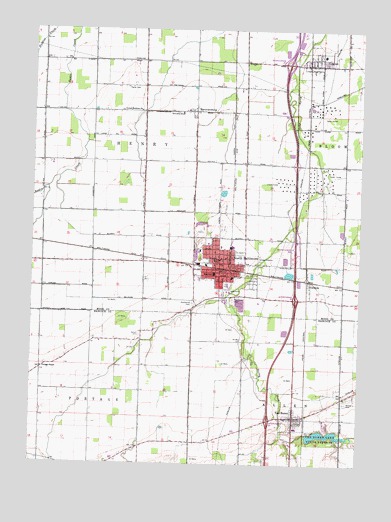
North Baltimore, OH USGS Topographic Map
Click on map above to begin viewing in our Map Viewer.

This topographic map contains these locations and features:
Feature Name Type Latitude Longitude GNIS ID View Map
Allen Township Volunteer Fire Department Station 1 HeadquartersBuildingN41.1384°W83.6489°2549980View Map
Allen Township Volunteer Fire Department Station 2BuildingN41.1424°W83.6347°2550615View Map
Bassett (historical)Populated PlaceN41.2120°W83.6735°1063331View Map
Bechel CemeteryCemeteryN41.1428°W83.6302°1037776View Map
Bethel Baptist ChurchChurchN41.1853°W83.6735°1960982View Map
Bethel CemeteryCemeteryN41.1623°W83.7085°1037898View Map
Blakely Care CenterBuildingN41.1737°W83.6683°1960983View Map
Briar Hill Golf CourseLocaleN41.1709°W83.6649°1050468View Map
Callahan RidgeRidgeN41.2292°W83.7222°1063333View Map
Church of Our LadyChurchN41.1867°W83.6774°1731422View Map
CygnetPopulated PlaceN41.2401°W83.6433°1056858View Map
Cygnet Branch Wayne Public LibraryBuildingN41.2401°W83.6427°1951679View Map
Cygnet CemeteryCemeteryN41.2404°W83.6321°1731423View Map
Cygnet Fire DepartmentBuildingN41.2398°W83.6439°2549360View Map
Cygnet Post OfficePost OfficeN41.2398°W83.6433°1951680View Map
DenverPopulated PlaceN41.1831°W83.7074°1050464View Map
E A Powell Elementary SchoolSchoolN41.1839°W83.6805°1050467View Map
Eagle Landing Mobile Home ParkPopulated PlaceN41.1845°W83.6580°1951685View Map
Faith Alliance ChurchChurchN41.1826°W83.6780°1960984View Map
Faith United Methodist ChurchChurchN41.2414°W83.6419°1806136View Map
Fayler CemeteryCemeteryN41.2334°W83.7147°1040401View Map
GalateaPopulated PlaceN41.1778°W83.6447°1064697View Map
Good Shepherd United Methodist ChurchChurchN41.1826°W83.6794°1731425View Map
HammansburgPopulated PlaceN41.2264°W83.6885°1056306View Map
Henry Township HouseBuildingN41.1903°W83.6816°1951778View Map
Hough CemeteryCemeteryN41.1903°W83.6811°1731427View Map
Howard RidgeRidgeN41.2001°W83.7249°1063336View Map
Interchange 164CrossingN41.1376°W83.6588°1077473View Map
Interchange 167CrossingN41.1726°W83.6494°1077474View Map
Interchange 168CrossingN41.1856°W83.6494°1077475View Map
Interchange 171CrossingN41.2406°W83.6524°1077476View Map
Lake Shore TrailTrailN41.1328°W83.6360°1962896View Map
Maple CemeteryCemeteryN41.1720°W83.6733°1042931View Map
Maplewood CemeteryCemeteryN41.1720°W83.6730°1731432View Map
Maplewood CemeteryCemeteryN41.1712°W83.6888°1042979View Map
North BaltimorePopulated PlaceN41.1828°W83.6783°1056452View Map
North Baltimore Church of ChristChurchN41.1842°W83.6777°1731438View Map
North Baltimore Emergency Medical ServicesBuildingN41.1830°W83.6787°2550857View Map
North Baltimore Fire DepartmentBuildingN41.1830°W83.6787°2549334View Map
North Baltimore High SchoolSchoolN41.1795°W83.6805°1050465View Map
North Baltimore Middle SchoolSchoolN41.1801°W83.6808°1050466View Map
North Baltimore Police DepartmentBuildingN41.1832°W83.6787°2732838View Map
North Baltimore Post OfficePost OfficeN41.1826°W83.6774°1082363View Map
North Baltimore Public LibraryBuildingN41.1839°W83.6783°1951923View Map
North Baltimore ReservoirReservoirN41.1684°W83.6666°1078973View Map
North Baltimore Upground Reservoir DamDamN41.1684°W83.6666°1078972View Map
Oil Center (historical)Populated PlaceN41.2112°W83.6449°1050469View Map
Pentecostal Church of GodChurchN41.1831°W83.6835°1960985View Map
Portage ChapelChurchN41.1526°W83.7458°1044700View Map
Radar CemeteryCemeteryN41.1314°W83.6499°1730833View Map
Saint James United Methodist ChurchChurchN41.1789°W83.6797°1731446View Map
Saint Lukes Lutheran ChurchChurchN41.1834°W83.6802°1731447View Map
Tank SidingLocaleN41.2253°W83.6452°1062561View Map
Township of AllenCivilN41.1254°W83.6500°1086238View Map
Township of HenryCivilN41.2115°W83.7077°1087184View Map
United Brethren ChurchChurchN41.2267°W83.7094°1047347View Map
Van BurenPopulated PlaceN41.1387°W83.6494°1056557View Map
Van Buren Elementary SchoolSchoolN41.1344°W83.6485°1054456View Map
Van Buren High SchoolSchoolN41.1351°W83.6482°1054457View Map
Van Buren LakeReservoirN41.1336°W83.6383°1078398View Map
Van Buren Lake DamDamN41.1337°W83.6443°1078397View Map
Van Buren Lake State ParkParkN41.1337°W83.6441°1061722View Map
Van Buren Post OfficePost OfficeN41.1389°W83.6499°1990237View Map
Village of CygnetCivilN41.2407°W83.6437°2398665View Map
Village of North BaltimoreCivilN41.1799°W83.6702°2399509View Map
Village of Van BurenCivilN41.1389°W83.6493°2400043View Map
Walnut Powell SchoolSchoolN41.1839°W83.6805°1047522View Map
Westhaven Senior Citizens ComplexBuildingN41.1798°W83.6855°1960986View Map
Windswept AirportAirportN41.1985°W83.7005°1082902View Map

Note: Coordinates in the location and feature list above are referenced to NAD83 datum.


Copyright (C) 2008-2025 Ryan Niemi / Sunset Dynamics ... All Rights Reserved