TopoQuest Logo
Do you find TopoQuest useful?
Help keep TopoQuest running and adding new maps/features by donating!
Bitcoin:  19c7KJd3qBynnjoSw5npx9KScwjBe4ifkT
Litecoin:  LXs6TkuXGGXo1vDsWCkWVdjQX94eUKd6ui
Home View Maps Find Maps Find Places Resources & Links


North Conway West, New Hampshire Topographic Map

USGS Map Title: North Conway West, NH
USGS Map MRC: 44071A2
DRG (GeoTIFF) Download: o44071a2.tif


Neighboring USGS Topographic Map Quads:


  Stairs Mountain, NH  
44071B3
 

  Jackson, NH  
44071B2
 

  Chatham, NH  
44071B1
 

  Bartlett, NH  
44071A3
 

  North Conway West, NH  
44071A2
 

  North Conway East, NH  
44071A1
 

  Mount Chocorua, NH  
43071H3
 

  Silver Lake, NH  
43071H2
 

  Conway, NH  
43071H1


Map MRC Location:

N45°
W72°
N45°
W71°
H8 H7 H6 H5 H4 H3 H2 H1
G8 G7 G6 G5 G4 G3 G2 G1
F8 F7 F6 F5 F4 F3 F2 F1
E8 E7 E6 E5 E4 E3 E2 E1
D8 D7 D6 D5 D4 D3 D2 D1
C8 C7 C6 C5 C4 C3 C2 C1
B8 B7 B6 B5 B4 B3 B2 B1
A8 A7 A6 A5 A4 A3 A2 A1
N44°
W72°
N44°
W71°

North Conway West, NH USGS 1:24K Topographic Map Preview:
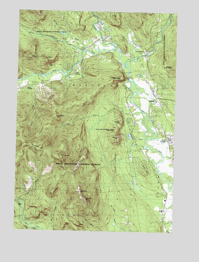
North Conway West, NH USGS Topographic Map
Click on map above to begin viewing in our Map Viewer.

This topographic map contains these locations and features:
Feature Name Type Latitude Longitude GNIS ID View Map
Albany BridgeBridgeN44.0059°W71.2406°1915867View Map
Attitash Bear Peak Ski AreaLocaleN44.0828°W71.2295°1915871View Map
Attitash TrailTrailN44.0434°W71.2476°873026View Map
Attitash Winter Sports AreaLocaleN44.0773°W71.2284°873032View Map
Bartlett - Jackson Emergency ServicesBuildingN44.1095°W71.1876°2658899View Map
Bartlett BridgeBridgeN44.0948°W71.2037°1915875View Map
Bartlett Fire DepartmentBuildingN44.1097°W71.1874°2605182View Map
Bartlett Police DeptBuildingN44.1022°W71.1476°2752923View Map
Big Attitash MountainSummitN44.0465°W71.2312°871497View Map
Birch HillSummitN44.0334°W71.1462°871510View Map
Bruce PathTrailN44.0612°W71.1703°873035View Map
Cathedral LedgeBenchN44.0634°W71.1673°871646View Map
Christ Episcopal ChurchChurchN44.0556°W71.1295°1915916View Map
Cooks CrossingPopulated PlaceN44.0898°W71.2056°871726View Map
Covered Bridge CampgroundLocaleN44.0042°W71.2326°873031View Map
Covered Bridge CampgroundLocaleN44.0040°W71.2317°1915930View Map
Cow BrookStreamN44.0923°W71.2059°871730View Map
Cow Brook TrailTrailN44.0851°W71.1795°871731View Map
Deer BrookStreamN44.0156°W71.2456°871774View Map
Dianas BathsSpringN44.0762°W71.1806°873034View Map
East Branch Saco RiverStreamN44.0956°W71.1645°871827View Map
Echo LakeLakeN44.0545°W71.1601°871847View Map
Echo Lake-Cathedral Ledge State ParkParkN44.0612°W71.1703°1915949View Map
Ellis RiverStreamN44.1045°W71.1723°871856View Map
Elm BrookStreamN44.0531°W71.1470°871860View Map
First Baptist ChurchChurchN44.0501°W71.1256°1915958View Map
First Church of ChristChurchN44.0659°W71.1251°1915961View Map
Forbes HeliportAirportN44.0453°W71.1573°873431View Map
Gardiner BrookStreamN44.1234°W71.1292°871920View Map
GlenPopulated PlaceN44.1101°W71.1826°871937View Map
Glen Post OfficePost OfficeN44.1094°W71.1850°1915973View Map
Hale's LocationCivilN44.0384°W71.1709°871993View Map
HaystackPillarN44.0037°W71.2009°872024View Map
Humphreys LedgeBenchN44.0881°W71.1651°872060View Map
Humphreys Ledge TrailTrailN44.0737°W71.2109°872061View Map
International Mountain Climbing SchoolSchoolN44.0539°W71.1282°2500282View Map
IntervalePopulated PlaceN44.0742°W71.1401°872079View Map
Intervale Nordic Learning CenterLocaleN44.0778°W71.1365°1915989View Map
Intervale Post OfficePost OfficeN44.0735°W71.1373°1915990View Map
Intervale Ski AreaLocaleN44.1045°W71.1403°873033View Map
JerichoPopulated PlaceN44.1078°W71.2040°872104View Map
John H Fuller Elementary SchoolSchoolN44.0568°W71.1278°1916004View Map
Kearsarge BrookStreamN44.0426°W71.1326°872125View Map
Kittredge PondLakeN44.1127°W71.2151°873029View Map
Little Attitash MountainSummitN44.0637°W71.2220°872181View Map
Lower BartlettPopulated PlaceN44.1023°W71.1501°872228View Map
Lucy BrookStreamN44.0681°W71.1503°872232View Map
Lucy Brook TrailTrailN44.0434°W71.2278°872233View Map
Meadow PondReservoirN44.1134°W71.2078°1775809View Map
Meadow Pond DamDamN44.1134°W71.2078°1775808View Map
Memorial HospitalHospitalN44.0618°W71.1370°1916041View Map
Middle Moat MountainSummitN44.0226°W71.1998°872289View Map
Moat Mountain TrailTrailN44.0640°W71.2009°872311View Map
Mount PickeringSummitN44.0984°W71.2401°872494View Map
Mount StantonSummitN44.0973°W71.2287°872729View Map
Mount SurpriseSummitN44.0837°W71.1265°872766View Map
Mountain BrookStreamN44.1031°W71.1965°872360View Map
Mountain View Montessori SchoolSchoolN44.0703°W71.1432°2500257View Map
New Hampshire Washington Valley Chamber of CommerceBuildingN44.0542°W71.1301°1916062View Map
North ConwayPopulated PlaceN44.0537°W71.1284°872395View Map
North Conway DepotLocaleN44.0559°W71.1298°1916066View Map
North Conway Fire DepartmentBuildingN44.0511°W71.1283°2605044View Map
North Moat MountainSummitN44.0431°W71.2153°872402View Map
Our Lady of the Mountains ChurchChurchN44.0526°W71.1273°1916074View Map
Red RidgeRidgeN44.0392°W71.1998°872556View Map
Red Ridge TrailTrailN44.0501°W71.1862°873036View Map
Rocky BranchStreamN44.1026°W71.1987°872579View Map
Rogers CrossingPopulated PlaceN44.0817°W71.2437°872585View Map
South Moat MountainSummitN44.0176°W71.1942°872703View Map
Spruce HillSummitN44.0145°W71.2476°872718View Map
Stony BrookStreamN44.0887°W71.2323°872748View Map
StorylandLocaleN44.1120°W71.1784°873030View Map
Swift River Civilian Conservation Corps Camp (historical)LocaleN44.0009°W71.2362°1916128View Map
Thompson FallsFallsN44.0415°W71.1792°872803View Map
Thorn HillSummitN44.1231°W71.1717°872807View Map
Town of BartlettCivilN44.0802°W71.2336°873539View Map
White Horse LedgeBenchN44.0523°W71.1698°872909View Map
White Horse TrailTrailN44.0501°W71.1681°873039View Map
Whites LedgeBenchN44.0945°W71.2267°872923View Map
Whitten BrookStreamN44.1201°W71.1301°872930View Map

Note: Coordinates in the location and feature list above are referenced to NAD83 datum.


Copyright (C) 2008-2024 Ryan Niemi / Sunset Dynamics ... All Rights Reserved