TopoQuest Logo
Do you find TopoQuest useful?
Help keep TopoQuest running and adding new maps/features by donating!
Bitcoin:  19c7KJd3qBynnjoSw5npx9KScwjBe4ifkT
Litecoin:  LXs6TkuXGGXo1vDsWCkWVdjQX94eUKd6ui
Home View Maps Find Maps Find Places Resources & Links


North Lewisburg, Ohio Topographic Map

USGS Map Title: North Lewisburg, OH
USGS Map MRC: 40083B5
DRG (GeoTIFF) Download: o40083b5.tif


Neighboring USGS Topographic Map Quads:


  Zanesfield, OH  
40083C6
 

  East Liberty, OH  
40083C5
 

  Peoria, OH  
40083C4
 

  Kingscreek, OH  
40083B6
 

  North Lewisburg, OH  
40083B5
 

  Milford Center, OH  
40083B4
 

  Urbana East, OH  
40083A6
 

  Mechanicsburg, OH  
40083A5
 

  Plumwood, OH  
40083A4


Map MRC Location:

N41°
W84°
N41°
W83°
H8 H7 H6 H5 H4 H3 H2 H1
G8 G7 G6 G5 G4 G3 G2 G1
F8 F7 F6 F5 F4 F3 F2 F1
E8 E7 E6 E5 E4 E3 E2 E1
D8 D7 D6 D5 D4 D3 D2 D1
C8 C7 C6 C5 C4 C3 C2 C1
B8 B7 B6 B5 B4 B3 B2 B1
A8 A7 A6 A5 A4 A3 A2 A1
N40°
W84°
N40°
W83°

North Lewisburg, OH USGS 1:24K Topographic Map Preview:
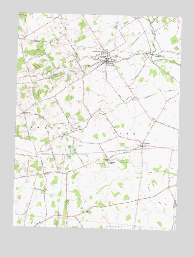
North Lewisburg, OH USGS Topographic Map
Click on map above to begin viewing in our Map Viewer.

This topographic map contains these locations and features:
Feature Name Type Latitude Longitude GNIS ID View Map
Beltz CemeteryCemeteryN40.2245°W83.6196°1037845View Map
Black CemeteryCemeteryN40.1945°W83.5619°1038072View Map
Broderick CemeteryCemeteryN40.2284°W83.5002°1038338View Map
Brush LakeLakeN40.1704°W83.5813°1038417View Map
Brush Lake (historical)Populated PlaceN40.1681°W83.5774°1063622View Map
Butcher CemeteryCemeteryN40.2239°W83.5641°1038560View Map
Corbet CemeteryCemeteryN40.1737°W83.6016°1039366View Map
Crimville (historical)Populated PlaceN40.1314°W83.5833°1054979View Map
Darby ChurchChurchN40.2470°W83.5241°1039577View Map
Fountain ParkPopulated PlaceN40.1651°W83.5541°1040609View Map
Fountain Park Post Office (historical)Post OfficeN40.1653°W83.5541°1965542View Map
Graham CemeteryCemeteryN40.2348°W83.5955°1041017View Map
Immaculate Conception ChurchChurchN40.2284°W83.5596°1041920View Map
Jenkins ChapelChurchN40.1553°W83.6083°1064906View Map
Jenkins Chapel CemeteryCemeteryN40.1562°W83.6085°1961146View Map
Maple Grove CemeteryCemeteryN40.2195°W83.5752°1042941View Map
Martin CemeteryCemeteryN40.1897°W83.5183°1043023View Map
Mead CemeteryCemeteryN40.1962°W83.6135°1043187View Map
Meadows of North LewisburgPopulated PlaceN40.2133°W83.5686°2630817View Map
MiddletownPopulated PlaceN40.1917°W83.6191°1061518View Map
North East Champaign County Fire DistrictBuildingN40.2232°W83.5554°2549517View Map
North LewisburgPopulated PlaceN40.2231°W83.5574°1065171View Map
North Lewisburg Post OfficePost OfficeN40.2237°W83.5583°1965189View Map
Quaker CemeteryCemeteryN40.2280°W83.5590°2516304View Map
Sodom CemeteryCemeteryN40.1349°W83.5691°1046420View Map
Spain CreekStreamN40.2284°W83.5221°1046515View Map
Spain Creek BridgeBridgeN40.2287°W83.5233°1055650View Map
Township of RushCivilN40.1780°W83.5419°1085845View Map
Triad Elementary SchoolSchoolN40.1803°W83.5885°1054999View Map
Triad High SchoolSchoolN40.1795°W83.5877°1047141View Map
Triad SchoolSchoolN40.1745°W83.5291°1047142View Map
Upper Darby BridgeBridgeN40.2492°W83.5333°1055667View Map
Village of North LewisburgCivilN40.2206°W83.5584°2399517View Map
Village of WoodstockCivilN40.1737°W83.5278°2399738View Map
White School (historical)SchoolN40.2131°W83.6152°1055004View Map
WoodstockPopulated PlaceN40.1739°W83.5274°1061801View Map
Woodstock CemeteryCemeteryN40.1726°W83.5363°1048121View Map

Note: Coordinates in the location and feature list above are referenced to NAD83 datum.


Copyright (C) 2008-2024 Ryan Niemi / Sunset Dynamics ... All Rights Reserved