TopoQuest Logo
Do you find TopoQuest useful?
Help keep TopoQuest running and adding new maps/features by donating!
Bitcoin:  19c7KJd3qBynnjoSw5npx9KScwjBe4ifkT
Litecoin:  LXs6TkuXGGXo1vDsWCkWVdjQX94eUKd6ui
Home View Maps Find Maps Find Places Resources & Links


Milford Center, Ohio Topographic Map

USGS Map Title: Milford Center, OH
USGS Map MRC: 40083B4
DRG (GeoTIFF) Download: o40083b4.tif


Neighboring USGS Topographic Map Quads:


  East Liberty, OH  
40083C5
 

  Peoria, OH  
40083C4
 

  Magnetic Springs, OH  
40083C3
 

  North Lewisburg, OH  
40083B5
 

  Milford Center, OH  
40083B4
 

  Marysville, OH  
40083B3
 

  Mechanicsburg, OH  
40083A5
 

  Plumwood, OH  
40083A4
 

  Plain City, OH  
40083A3


Map MRC Location:

N41°
W84°
N41°
W83°
H8 H7 H6 H5 H4 H3 H2 H1
G8 G7 G6 G5 G4 G3 G2 G1
F8 F7 F6 F5 F4 F3 F2 F1
E8 E7 E6 E5 E4 E3 E2 E1
D8 D7 D6 D5 D4 D3 D2 D1
C8 C7 C6 C5 C4 C3 C2 C1
B8 B7 B6 B5 B4 B3 B2 B1
A8 A7 A6 A5 A4 A3 A2 A1
N40°
W84°
N40°
W83°

Milford Center, OH USGS 1:24K Topographic Map Preview:
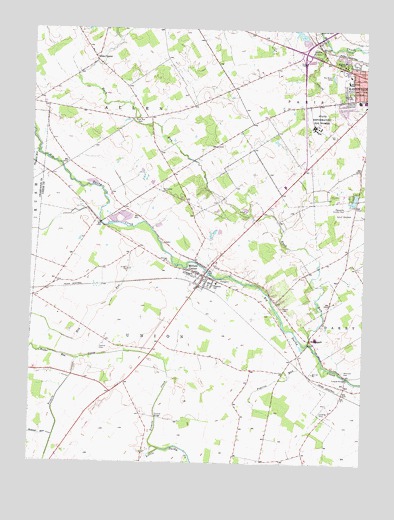
Milford Center, OH USGS Topographic Map
Click on map above to begin viewing in our Map Viewer.

This topographic map contains these locations and features:
Feature Name Type Latitude Longitude GNIS ID View Map
Allen CenterPopulated PlaceN40.2417°W83.4780°1060818View Map
Allen Centre Post Office (historical)Post OfficeN40.2417°W83.4778°2074216View Map
Allen Township Fire and Rescue DepartmentBuildingN40.2408°W83.4771°2550457View Map
Allen Township HallBuildingN40.2409°W83.4766°1955553View Map
Barr Haven ParkParkN40.2270°W83.3810°1055576View Map
BridgeportPopulated PlaceN40.1606°W83.3946°1062661View Map
Buck RunStreamN40.1589°W83.3958°1065944View Map
Buck Run CemeteryCemeteryN40.2245°W83.4608°1038468View Map
Church of ChristChurchN40.2381°W83.3816°1056031View Map
Connor CemeteryCemeteryN40.1578°W83.4741°1039315View Map
Crane SwampSwampN40.1995°W83.4822°1067256View Map
Darby AirportAirportN40.1413°W83.3893°1082862View Map
Edgewood Elementary SchoolSchoolN40.2356°W83.3816°1081253View Map
Fairbanks High SchoolSchoolN40.1767°W83.4302°1055602View Map
Flagstone Golf CourseLocaleN40.1967°W83.3824°1955653View Map
Green PasturesPopulated PlaceN40.2319°W83.3905°2771076View Map
Hay RunStreamN40.1851°W83.4494°1041419View Map
Heart of Ohio Fish and Game Association ReservoirReservoirN40.2465°W83.3979°1078630View Map
Hickory RunPopulated PlaceN40.2025°W83.3920°2771078View Map
Howard RunStreamN40.1326°W83.4908°1041826View Map
Hunters RunPopulated PlaceN40.2323°W83.4516°2771079View Map
Marysville Country ClubLocaleN40.1987°W83.3824°1080144View Map
Marysville Plaza Shopping CenterLocaleN40.2398°W83.3874°1055621View Map
McDonald CemeteryCemeteryN40.2031°W83.4516°1043100View Map
Memorial ParkParkN40.2406°W83.3846°1055627View Map
Milford CenterPopulated PlaceN40.1787°W83.4355°1061524View Map
Milford Center CemeteryCemeteryN40.1773°W83.4269°1961362View Map
Milford Center Post OfficePost OfficeN40.1786°W83.4347°1955561View Map
Milford Center Prairie State Nature PreserveParkN40.1523°W83.4619°1961363View Map
Milford Center Village HallBuildingN40.1787°W83.4366°1955556View Map
Milford EstatesPopulated PlaceN40.2140°W83.3937°2771080View Map
Oakdale CemeteryCemeteryN40.2434°W83.3929°1044052View Map
Ohio Reformatory for WomenBuildingN40.2223°W83.3938°1055636View Map
Ohio Reformatory For Women Correctional FacilityBuildingN40.2243°W83.3931°2722712View Map
Our Lady of Lourdes Catholic ChurchChurchN40.2389°W83.3852°1056034View Map
Pleasant RunStreamN40.2145°W83.4983°1044581View Map
Prairie RunStreamN40.1576°W83.3983°1044748View Map
Proctor RunStreamN40.1542°W83.4819°1057940View Map
Ray Lewis ParkParkN40.2314°W83.3802°1055641View Map
Reed BridgeBridgeN40.1498°W83.3810°1055643View Map
Robinson CemeteryCemeteryN40.1517°W83.3824°1061184View Map
Saint Johns CemeteryCemeteryN40.2455°W83.3917°1045511View Map
Scott Circle ParkParkN40.2417°W83.3791°1055646View Map
Timberview Golf ClubLocaleN40.2167°W83.3766°1955655View Map
Township of AllenCivilN40.2449°W83.4867°1087073View Map
Township of ParisCivilN40.2459°W83.3753°1087082View Map
Township of UnionCivilN40.1559°W83.4449°1087084View Map
Treacle CreekStreamN40.1287°W83.4510°1066241View Map
Treacle Creek BridgeBridgeN40.1381°W83.4524°1055663View Map
Union Township Fire and Emergency Medical Services DepartmentBuildingN40.1791°W83.4368°2549512View Map
Union Township HallBuildingN40.1792°W83.4369°1955558View Map
Village of Milford CenterCivilN40.1791°W83.4381°2399346View Map
Wolf School (historical)SchoolN40.1884°W83.3802°1055671View Map
Woods CemeteryCemeteryN40.1699°W83.4056°1048103View Map

Note: Coordinates in the location and feature list above are referenced to NAD83 datum.


Copyright (C) 2008-2025 Ryan Niemi / Sunset Dynamics ... All Rights Reserved