TopoQuest Logo
Do you find TopoQuest useful?
Help keep TopoQuest running and adding new maps/features by donating!
Bitcoin:  19c7KJd3qBynnjoSw5npx9KScwjBe4ifkT
Litecoin:  LXs6TkuXGGXo1vDsWCkWVdjQX94eUKd6ui
Home View Maps Find Maps Find Places Resources & Links


Peoria, Ohio Topographic Map

USGS Map Title: Peoria, OH
USGS Map MRC: 40083C4
DRG (GeoTIFF) Download: o40083c4.tif


Neighboring USGS Topographic Map Quads:


  West Mansfield, OH  
40083D5
 

  York Center, OH  
40083D4
 

  Richwood, OH  
40083D3
 

  East Liberty, OH  
40083C5
 

  Peoria, OH  
40083C4
 

  Magnetic Springs, OH  
40083C3
 

  North Lewisburg, OH  
40083B5
 

  Milford Center, OH  
40083B4
 

  Marysville, OH  
40083B3


Map MRC Location:

N41°
W84°
N41°
W83°
H8 H7 H6 H5 H4 H3 H2 H1
G8 G7 G6 G5 G4 G3 G2 G1
F8 F7 F6 F5 F4 F3 F2 F1
E8 E7 E6 E5 E4 E3 E2 E1
D8 D7 D6 D5 D4 D3 D2 D1
C8 C7 C6 C5 C4 C3 C2 C1
B8 B7 B6 B5 B4 B3 B2 B1
A8 A7 A6 A5 A4 A3 A2 A1
N40°
W84°
N40°
W83°

Peoria, OH USGS 1:24K Topographic Map Preview:
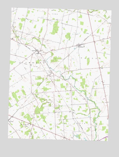
Peoria, OH USGS Topographic Map
Click on map above to begin viewing in our Map Viewer.

This topographic map contains these locations and features:
Feature Name Type Latitude Longitude GNIS ID View Map
Amarine School (historical)SchoolN40.2537°W83.4291°1055572View Map
Amerine CemeteryCemeteryN40.2501°W83.3936°1037404View Map
Asbury CemeteryCemeteryN40.3193°W83.3861°1037499View Map
Asbury School (historical)SchoolN40.3201°W83.3766°1055574View Map
Baughn CemeteryCemeteryN40.3253°W83.4552°1037688View Map
Bear Swamp (historical)SwampN40.2759°W83.4763°1055577View Map
Bear Swamp RunStreamN40.2609°W83.4741°1067254View Map
Bliss DairyLocaleN40.3272°W83.4256°2705627View Map
Blue School (historical)SchoolN40.2756°W83.4424°1055585View Map
Bokes Creek School (historical)SchoolN40.3623°W83.3752°1055587View Map
Braum School (historical)SchoolN40.3003°W83.3846°1055591View Map
BroadwayPopulated PlaceN40.3412°W83.4121°1056725View Map
Broadway CemeteryCemeteryN40.3395°W83.4077°1961359View Map
Broadway Post OfficePost OfficeN40.3417°W83.4125°2074241View Map
Calvary ChurchChurchN40.3473°W83.3844°1038646View Map
Carter School (historical)SchoolN40.3403°W83.4391°1055597View Map
Clark CemeteryCemeteryN40.3206°W83.4746°1039137View Map
East Elementary SchoolSchoolN40.2643°W83.3841°1081234View Map
Ford CemeteryCemeteryN40.3626°W83.3752°1040548View Map
Fruit-Full AcresLocaleN40.2867°W83.4039°2515699View Map
Hamilton CemeteryCemeteryN40.2896°W83.4046°1041261View Map
Henpeck School (historical)SchoolN40.2609°W83.4596°1055610View Map
Liberty Township Fire Department and Emergency Medical Services DepartmentBuildingN40.3353°W83.4670°2550275View Map
Mount Zion CemeteryCemeteryN40.2520°W83.4179°1043651View Map
North Western High SchoolSchoolN40.3326°W83.4641°1043977View Map
Ohio State Highway Patrol - Marysville Patrol PostBuildingN40.2669°W83.4774°2733098View Map
OtterPopulated PlaceN40.2759°W83.4191°1049046View Map
Otter RunStreamN40.2817°W83.3888°1044218View Map
PeoriaPopulated PlaceN40.3139°W83.4458°1049075View Map
Peoria Post Office (historical)Post OfficeN40.3139°W83.4456°2074314View Map
RaymondPopulated PlaceN40.3348°W83.4658°1057946View Map
Raymond CemeteryCemeteryN40.3348°W83.4616°1044877View Map
Raymond Census Designated PlaceCensusN40.3350°W83.4635°2628957View Map
Raymond Elementary SchoolSchoolN40.3323°W83.4649°1055642View Map
Raymond Post OfficePost OfficeN40.3347°W83.4656°2074318View Map
Shirk School (historical)SchoolN40.2959°W83.4141°1055649View Map
Stub School (historical)SchoolN40.2712°W83.4144°1055655View Map
Taylor Centre (historical)Populated PlaceN40.3448°W83.3958°1067260View Map
Taylor Centre Post Office (historical)Post OfficeN40.3444°W83.3944°2074320View Map
Taylor School (historical)SchoolN40.3717°W83.4202°1055660View Map
Township of LibertyCivilN40.3297°W83.4852°1087080View Map
Township of TaylorCivilN40.3339°W83.3881°1087083View Map

Note: Coordinates in the location and feature list above are referenced to NAD83 datum.


Copyright (C) 2008-2025 Ryan Niemi / Sunset Dynamics ... All Rights Reserved