TopoQuest Logo
Do you find TopoQuest useful?
Help keep TopoQuest running and adding new maps/features by donating!
Bitcoin:  19c7KJd3qBynnjoSw5npx9KScwjBe4ifkT
Litecoin:  LXs6TkuXGGXo1vDsWCkWVdjQX94eUKd6ui
Home View Maps Find Maps Find Places Resources & Links


North Sister, Oregon Topographic Map

USGS Map Title: North Sister, OR
USGS Map MRC: 44121B7
DRG (GeoTIFF) Download: o44121b7.tif


Neighboring USGS Topographic Map Quads:


  Clear Lake, OR  
44121C8
 

  Mount Washington, OR  
44121C7
 

  Black Crater, OR  
44121C6
 

  Linton Lake, OR  
44121B8
 

  North Sister, OR  
44121B7
 

  Trout Creek Butte, OR  
44121B6
 

  Substitute Point, OR  
44121A8
 

  South Sister, OR  
44121A7
 

  Broken Top, OR  
44121A6


Map MRC Location:

N45°
W122°
N45°
W121°
H8 H7 H6 H5 H4 H3 H2 H1
G8 G7 G6 G5 G4 G3 G2 G1
F8 F7 F6 F5 F4 F3 F2 F1
E8 E7 E6 E5 E4 E3 E2 E1
D8 D7 D6 D5 D4 D3 D2 D1
C8 C7 C6 C5 C4 C3 C2 C1
B8 B7 B6 B5 B4 B3 B2 B1
A8 A7 A6 A5 A4 A3 A2 A1
N44°
W122°
N44°
W121°

North Sister, OR USGS 1:24K Topographic Map Preview:
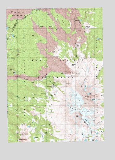
North Sister, OR USGS Topographic Map
Click on map above to begin viewing in our Map Viewer.

This topographic map contains these locations and features:
Feature Name Type Latitude Longitude GNIS ID View Map
Ahalapam Cinder FieldLavaN44.2026°W121.7828°1137036View Map
Bronaugh Memorial PlaqueParkN44.1765°W121.8167°1163684View Map
Camp LakeLakeN44.1320°W121.7606°1154155View Map
Campers LakeLakeN44.2249°W121.8677°1139290View Map
Carver GlacierGlacierN44.1255°W121.7680°1139409View Map
Chambers LakesGlacierN44.1261°W121.7748°1139555View Map
Chief Joseph IslandFlatN44.2268°W121.7887°1851710View Map
Collier ConeSummitN44.1887°W121.7844°1139991View Map
Collier GlacierGlacierN44.1650°W121.7850°1139993View Map
Collier Glacier ViewLocaleN44.1865°W121.7909°1139994View Map
Condon ButteSummitN44.2248°W121.8402°1140029View Map
Craig GraveCemeteryN44.2459°W121.8439°1140358View Map
Craig LakeLakeN44.2492°W121.8364°1119501View Map
Diller GlacierGlacierN44.1416°W121.7717°1141028View Map
Eileen LakeLakeN44.1394°W121.8495°1141710View Map
Four in One ConeSummitN44.2079°W121.8117°1142351View Map
Frog Camp (historical)LocaleN44.2029°W121.8706°1142492View Map
Glacier CreekStreamN44.1837°W121.8264°1142750View Map
Glacier WayTrailN44.1812°W121.8225°1142755View Map
Harlow CraterCraterN44.2457°W121.7692°1851703View Map
Hayden GlacierGlacierN44.1521°W121.7747°1143402View Map
Huckleberry ButteSummitN44.2304°W121.8124°1143867View Map
Huckleberry LakeLakeN44.2440°W121.8227°1143876View Map
Husband LakeLakeN44.1287°W121.8419°1143966View Map
Irving GlacierGlacierN44.1354°W121.7786°1144130View Map
Lane PlateauPlainN44.1550°W121.8385°1144815View Map
Linn GlacierGlacierN44.1749°W121.7748°1145051View Map
Linton MeadowsFlatN44.1296°W121.8267°1639318View Map
Linton SpringSpringN44.1335°W121.8273°1145058View Map
Little BrotherSummitN44.1792°W121.7973°1145111View Map
Matthieu LakesLakeN44.2346°W121.7762°1158922View Map
Middle SisterSummitN44.1484°W121.7841°1146183View Map
Millican Crater TrailTrailN44.2437°W121.7589°1146290View Map
Minnie Scott SpringSpringN44.1962°W121.7917°1146338View Map
Montague Memorial PlaqueParkN44.1696°W121.8250°1163743View Map
North Matthieu LakeLakeN44.2384°W121.7795°1147037View Map
North SisterSummitN44.1665°W121.7723°1147062View Map
Obsidian CliffsCliffN44.1796°W121.8398°1158401View Map
Obsidian FallsFallsN44.1687°W121.8178°1116608View Map
Obsidian TrailTrailN44.1896°W121.8531°1147135View Map
Opie Dilldock PassGapN44.1907°W121.7917°1147255View Map
Prouty Memorial PlaqueParkN44.1771°W121.8173°1163765View Map
Renfrew GlacierGlacierN44.1551°W121.7921°1148374View Map
Sawyer BarBarN44.1882°W121.8020°1126626View Map
Scott PassGapN44.2329°W121.7750°1149172View Map
Scott TrailTrailN44.2110°W121.8331°1149175View Map
Sims ButteSummitN44.1927°W121.8695°1149533View Map
Sister SpringSpringN44.1685°W121.8159°1149547View Map
South Matthieu LakeLakeN44.2315°W121.7738°1158499View Map
Spring LakeLakeN44.1893°W121.8661°1150191View Map
Thayer GlacierGlacierN44.1636°W121.7638°1150996View Map
The HusbandSummitN44.1272°W121.8564°1151018View Map
The IslandFlatN44.2398°W121.8062°1151021View Map
Villard GlacierGlacierN44.1697°W121.7702°1151768View Map
West Lava CreekStreamN44.2496°W121.8370°1154152View Map
West Lava Forest Camp (historical)LocaleN44.2465°W121.8439°1152133View Map
Yapoah CraterCraterN44.2151°W121.7853°1152695View Map
Yapoah LakeLakeN44.2209°W121.7576°1152696View Map

Note: Coordinates in the location and feature list above are referenced to NAD83 datum.


Copyright (C) 2008-2025 Ryan Niemi / Sunset Dynamics ... All Rights Reserved