TopoQuest Logo
Do you find TopoQuest useful?
Help keep TopoQuest running and adding new maps/features by donating!
Bitcoin:  19c7KJd3qBynnjoSw5npx9KScwjBe4ifkT
Litecoin:  LXs6TkuXGGXo1vDsWCkWVdjQX94eUKd6ui
Home View Maps Find Maps Find Places Resources & Links


Northwest Eden, North Carolina Topographic Map

USGS Map Title: Northwest Eden, NC
USGS Map MRC: 36079E7
DRG (GeoTIFF) Download: o36079e7.tif


Neighboring USGS Topographic Map Quads:


  Martinsville West, VA  
36079F8
 

  Martinsville East, VA  
36079F7
 

  Axton, VA  
36079F6
 

  Price, NC  
36079E8
 

  Northwest Eden, NC  
36079E7
 

  Northeast Eden, NC  
36079E6
 

  Mayodan, NC  
36079D8
 

  Southwest Eden, NC  
36079D7
 

  Southeast Eden, NC  
36079D6


Map MRC Location:

N37°
W80°
N37°
W79°
H8 H7 H6 H5 H4 H3 H2 H1
G8 G7 G6 G5 G4 G3 G2 G1
F8 F7 F6 F5 F4 F3 F2 F1
E8 E7 E6 E5 E4 E3 E2 E1
D8 D7 D6 D5 D4 D3 D2 D1
C8 C7 C6 C5 C4 C3 C2 C1
B8 B7 B6 B5 B4 B3 B2 B1
A8 A7 A6 A5 A4 A3 A2 A1
N36°
W80°
N36°
W79°

Northwest Eden, NC USGS 1:24K Topographic Map Preview:
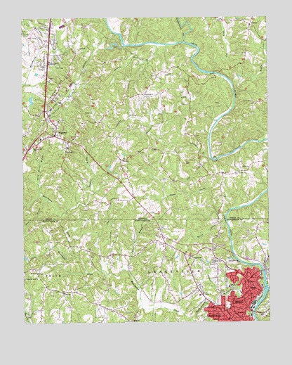
Northwest Eden, NC USGS Topographic Map
Click on map above to begin viewing in our Map Viewer.

This topographic map contains these locations and features:
Feature Name Type Latitude Longitude GNIS ID View Map
Bear BranchStreamN36.5501°W79.8620°1027374View Map
Bethel ChurchChurchN36.5635°W79.7598°1463157View Map
Black Knob School (historical)SchoolN36.5960°W79.7503°1497280View Map
Boiling Springs BranchStreamN36.5007°W79.7873°981689View Map
Brandywine EstatesPopulated PlaceN36.5321°W79.7984°1005938View Map
Break Reed FordCrossingN36.5712°W79.7648°1496813View Map
Burgess CreekStreamN36.6129°W79.8056°1464104View Map
Drag CreekStreamN36.5671°W79.7786°1465938View Map
Drag MountainSummitN36.5654°W79.7917°1465939View Map
Drewry Mason Middle School (historical)SchoolN36.6067°W79.8607°1465951View Map
Eden Fire Department Station 3BuildingN36.5163°W79.7602°2638640View Map
Egglestons FordCrossingN36.6143°W79.8228°1497299View Map
El Bethel Presbyterian ChurchChurchN36.5004°W79.8200°984672View Map
FairviewPopulated PlaceN36.5274°W79.7898°984907View Map
Fall CreekStreamN36.6015°W79.7770°1466444View Map
Fishers DamDamN36.6137°W79.8258°1466606View Map
Flanigan BranchStreamN36.5812°W79.8084°1466638View Map
Floyd Baptist ChurchChurchN36.5121°W79.8539°985248View Map
Friendly ChurchChurchN36.5668°W79.8239°1466889View Map
Friendship ChurchChurchN36.5918°W79.8120°1466891View Map
Glen CourtPopulated PlaceN36.6062°W79.8650°1497308View Map
Goodwill ChurchChurchN36.5615°W79.7645°1467231View Map
Grace ChurchChurchN36.6051°W79.8623°1467306View Map
Grassy ForkStreamN36.5815°W79.7753°1467371View Map
Hamilton HillsPopulated PlaceN36.5182°W79.7739°1005580View Map
Holland School (historical)SchoolN36.5007°W79.8203°1953150View Map
Hopper School (historical)SchoolN36.5601°W79.7820°1497316View Map
IrisburgPopulated PlaceN36.6207°W79.7584°1496955View Map
Jones BranchStreamN36.5354°W79.8361°987716View Map
Joppa School (historical)SchoolN36.5943°W79.8039°1497319View Map
Lakeside Elementary SchoolSchoolN36.5149°W79.7703°988094View Map
Leaksville (historical)Populated PlaceN36.5021°W79.7725°988253View Map
Leatherwood CreekStreamN36.6140°W79.7914°1469234View Map
Lithia SpringsPopulated PlaceN36.5907°W79.8473°1497324View Map
Little Marrowbone CreekStreamN36.6118°W79.8611°1469588View Map
Little Matrimony CreekStreamN36.5215°W79.8342°988704View Map
Long Island FordCrossingN36.6024°W79.7778°1497325View Map
Marrowbone CreekStreamN36.6135°W79.8225°1470104View Map
Marrowbone HeightsPopulated PlaceN36.6162°W79.8581°1497326View Map
Marrowbone School (historical)SchoolN36.6185°W79.8509°1497327View Map
Martin CreekStreamN36.5435°W79.7742°1470129View Map
MatrimonyPopulated PlaceN36.5204°W79.8675°1953151View Map
Matrimony Primitive Baptist ChurchChurchN36.5204°W79.8664°989466View Map
Matrimony School (historical)SchoolN36.5201°W79.8673°1953152View Map
Meal Hill School (historical)SchoolN36.6074°W79.8323°1497330View Map
Middle CreekStreamN36.5924°W79.7664°1470398View Map
Mountain View CemeteryCemeteryN36.5715°W79.8700°1471187View Map
New Bethel ChurchChurchN36.5704°W79.8528°1471387View Map
New Light ChurchChurchN36.6179°W79.8742°1471463View Map
Norman School (historical)SchoolN36.6193°W79.8742°1497337View Map
Osborne Baptist ChurchChurchN36.5115°W79.7831°991705View Map
Overlook CemeteryCemeteryN36.5246°W79.7782°991740View Map
Poplar BranchStreamN36.5215°W79.8214°992677View Map
Pratt School (historical)SchoolN36.5335°W79.8036°1953154View Map
QuesenburyPopulated PlaceN36.5010°W79.8220°1005581View Map
Reds CreekStreamN36.6137°W79.8353°1473081View Map
RidgewayPopulated PlaceN36.5768°W79.8584°1473206View Map
Ridgeway DistrictCivilN36.5897°W79.8533°1927461View Map
Ridgeway District Volunteer Fire Department Station 1BuildingN36.5771°W79.8572°2075349View Map
Ridgeway District Volunteer Rescue SquadBuildingN36.5769°W79.8564°2075348View Map
Ridgeway Elementary SchoolSchoolN36.5757°W79.8654°1497346View Map
Ridgeway Post OfficePost OfficeN36.5771°W79.8568°2766278View Map
Roberts Memorial Baptist ChurchChurchN36.5182°W79.8739°993454View Map
Saint Pauls ChurchChurchN36.5893°W79.7581°1473864View Map
Shannon HillsPopulated PlaceN36.6168°W79.8667°1497349View Map
Sheffield HillSummitN36.5965°W79.8570°1474466View Map
Sheffield TerracePopulated PlaceN36.6085°W79.8550°1497350View Map
Spray (historical)Populated PlaceN36.5162°W79.7606°1022742View Map
Spray Recreation ParkParkN36.5140°W79.7645°1953157View Map
Stuart CreekStreamN36.5437°W79.7717°1475261View Map
Surry Martin BranchStreamN36.5529°W79.8662°1475349View Map
Tackett BranchStreamN36.5032°W79.7586°995824View Map
The BendBendN36.5668°W79.7767°1475558View Map
Toeclout BranchStreamN36.5482°W79.8425°1475755View Map
Town of RidgewayCivilN36.5782°W79.8583°2391390View Map
Trent School (historical)SchoolN36.5665°W79.8223°1497356View Map
Turkeycock CreekStreamN36.5826°W79.7756°1475966View Map
Turkeypen BranchStreamN36.5671°W79.7800°1475971View Map

Note: Coordinates in the location and feature list above are referenced to NAD83 datum.


Copyright (C) 2008-2024 Ryan Niemi / Sunset Dynamics ... All Rights Reserved