TopoQuest Logo
Do you find TopoQuest useful?
Help keep TopoQuest running and adding new maps/features by donating!
Bitcoin:  19c7KJd3qBynnjoSw5npx9KScwjBe4ifkT
Litecoin:  LXs6TkuXGGXo1vDsWCkWVdjQX94eUKd6ui
Home View Maps Find Maps Find Places Resources & Links


Price, North Carolina Topographic Map

USGS Map Title: Price, NC
USGS Map MRC: 36079E8
DRG (GeoTIFF) Download: o36079e8.tif


Neighboring USGS Topographic Map Quads:


  Sanville, VA  
36080F1
 

  Martinsville West, VA  
36079F8
 

  Martinsville East, VA  
36079F7
 

  Spencer, VA  
36080E1
 

  Price, NC  
36079E8
 

  Northwest Eden, NC  
36079E7
 

  Ayersville, NC  
36080D1
 

  Mayodan, NC  
36079D8
 

  Southwest Eden, NC  
36079D7


Map MRC Location:

N37°
W80°
N37°
W79°
H8 H7 H6 H5 H4 H3 H2 H1
G8 G7 G6 G5 G4 G3 G2 G1
F8 F7 F6 F5 F4 F3 F2 F1
E8 E7 E6 E5 E4 E3 E2 E1
D8 D7 D6 D5 D4 D3 D2 D1
C8 C7 C6 C5 C4 C3 C2 C1
B8 B7 B6 B5 B4 B3 B2 B1
A8 A7 A6 A5 A4 A3 A2 A1
N36°
W80°
N36°
W79°

Price, NC USGS 1:24K Topographic Map Preview:
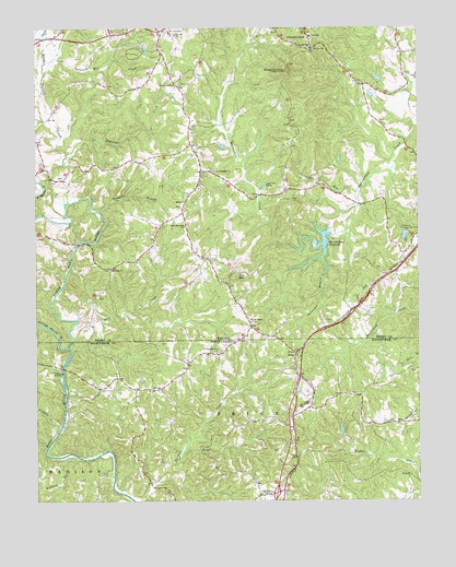
Price, NC USGS Topographic Map
Click on map above to begin viewing in our Map Viewer.

This topographic map contains these locations and features:
Feature Name Type Latitude Longitude GNIS ID View Map
Anglins BridgeBridgeN36.5351°W79.9909°1953147View Map
Buffalo CreekStreamN36.5199°W79.9914°982180View Map
Chestnut KnobPopulated PlaceN36.6240°W79.9106°1477199View Map
Chestnut KnobSummitN36.6137°W79.9173°1499250View Map
Christian View CemeteryCemeteryN36.5393°W79.9411°1953148View Map
Christian View Pentecostal Holiness ChurchChurchN36.5390°W79.9403°983177View Map
Clarke SchoolSchoolN36.6229°W79.9095°1464945View Map
Dunnivan School (historical)SchoolN36.5912°W79.9614°1497297View Map
Fall CreekStreamN36.5390°W79.9878°984974View Map
Green Spring School (historical)SchoolN36.5293°W79.9650°1953149View Map
Hickory CreekStreamN36.5115°W79.9862°986695View Map
Holmes Memorial ChurchChurchN36.6199°W79.9092°1468171View Map
Holt MountainSummitN36.5596°W79.9337°1468178View Map
Horse Pasture ChurchChurchN36.6096°W79.9531°1468267View Map
Horse Pasture CreekStreamN36.5793°W79.9898°1468268View Map
Horsepasture Volunteer Rescue SquadBuildingN36.6240°W79.9588°2075345View Map
Jennings CreekStreamN36.5896°W79.9900°1468684View Map
Jumping BranchStreamN36.5768°W79.9792°1468899View Map
Lakewood ForestPopulated PlaceN36.6185°W79.9675°1497320View Map
Lees Ford CampLocaleN36.5837°W79.9239°1469279View Map
Magna Vista High SchoolSchoolN36.5931°W79.8902°2498467View Map
Marrowbone Creek Number One DamDamN36.5701°W79.9031°1490095View Map
Marrowbone ReservoirReservoirN36.5689°W79.9057°1470107View Map
Matthews Chapel CemeteryCemeteryN36.5021°W79.9239°1953153View Map
Matthews Chapel United Methodist ChurchChurchN36.5021°W79.9234°989455View Map
Mayo ChurchChurchN36.5796°W79.9503°1470216View Map
Mount Zion ChurchChurchN36.5615°W79.9750°1471113View Map
Mount Zion ChurchChurchN36.6193°W79.9081°1471116View Map
Mount Zion School (historical)SchoolN36.5621°W79.9750°1497335View Map
Mountain School (historical)SchoolN36.5887°W79.9178°1497336View Map
Muddy CreekStreamN36.6235°W79.9964°1471224View Map
New Jerusalem ChurchChurchN36.5874°W79.9414°1471457View Map
North Mayo RiverStreamN36.5407°W79.9889°991245View Map
North Stoneyview Volunteer Fire DepartmentBuildingN36.5327°W79.9724°2638086View Map
Pace AirportAirportN36.5870°W79.8768°1498800View Map
Patrick Henry Correctional Unit 28BuildingN36.6232°W79.9552°2767061View Map
Patterson BranchStreamN36.5654°W79.9053°1472110View Map
PricePopulated PlaceN36.5390°W79.9148°1022076View Map
Price CemeteryCemeteryN36.5396°W79.9142°1953155View Map
Price United Methodist ChurchChurchN36.5393°W79.9142°1953156View Map
Rangeley School (historical)SchoolN36.5879°W79.9964°1497343View Map
Red Plain School (historical)SchoolN36.5821°W79.9150°1497344View Map
Ridgeway Sportsmen ClubLocaleN36.5715°W79.8787°1491238View Map
Smith Memorial ChurchChurchN36.5726°W79.9503°1474764View Map
South Mayo RiverStreamN36.5407°W79.9892°1474875View Map
Spencers Mill CreekStreamN36.6171°W79.9937°1474942View Map
Stillhouse RunStreamN36.5818°W79.8937°1475149View Map
Township of PriceCivilN36.5216°W79.9070°1027135View Map
Watkins School (historical)SchoolN36.5474°W79.9298°1497360View Map
Whites ChapelChurchN36.5474°W79.9292°1476663View Map

Note: Coordinates in the location and feature list above are referenced to NAD83 datum.


Copyright (C) 2008-2024 Ryan Niemi / Sunset Dynamics ... All Rights Reserved