TopoQuest Logo
Do you find TopoQuest useful?
Help keep TopoQuest running and adding new maps/features by donating!
Bitcoin:  19c7KJd3qBynnjoSw5npx9KScwjBe4ifkT
Litecoin:  LXs6TkuXGGXo1vDsWCkWVdjQX94eUKd6ui
Home View Maps Find Maps Find Places Resources & Links


Northeast Eden, North Carolina Topographic Map

USGS Map Title: Northeast Eden, NC
USGS Map MRC: 36079E6
DRG (GeoTIFF) Download: o36079e6.tif


Neighboring USGS Topographic Map Quads:


  Martinsville East, VA  
36079F7
 

  Axton, VA  
36079F6
 

  Whitmell, VA  
36079F5
 

  Northwest Eden, NC  
36079E7
 

  Northeast Eden, NC  
36079E6
 

  Brosville, VA  
36079E5
 

  Southwest Eden, NC  
36079D7
 

  Southeast Eden, NC  
36079D6
 

  Ruffin, NC  
36079D5


Map MRC Location:

N37°
W80°
N37°
W79°
H8 H7 H6 H5 H4 H3 H2 H1
G8 G7 G6 G5 G4 G3 G2 G1
F8 F7 F6 F5 F4 F3 F2 F1
E8 E7 E6 E5 E4 E3 E2 E1
D8 D7 D6 D5 D4 D3 D2 D1
C8 C7 C6 C5 C4 C3 C2 C1
B8 B7 B6 B5 B4 B3 B2 B1
A8 A7 A6 A5 A4 A3 A2 A1
N36°
W80°
N36°
W79°

Northeast Eden, NC USGS 1:24K Topographic Map Preview:
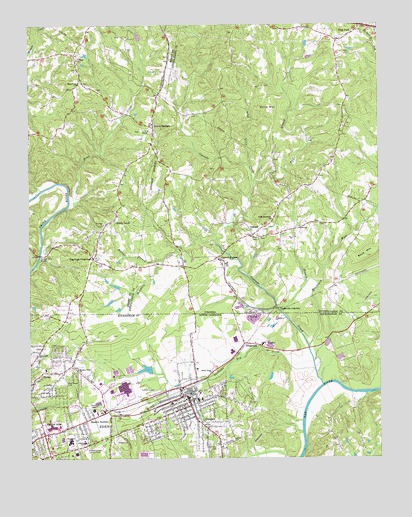
Northeast Eden, NC USGS Topographic Map
Click on map above to begin viewing in our Map Viewer.

This topographic map contains these locations and features:
Feature Name Type Latitude Longitude GNIS ID View Map
Aiken SummitPopulated PlaceN36.5951°W79.7048°1501937View Map
Black Knob School (historical)SchoolN36.5957°W79.7367°1497279View Map
Blue Creek CemeteryCemeteryN36.5221°W79.7373°981624View Map
CascadePopulated PlaceN36.5646°W79.6698°1477184View Map
Cascade CreekStreamN36.5212°W79.6453°982718View Map
Cascade Post OfficePost OfficeN36.5646°W79.6713°2766170View Map
Cascade StationLocaleN36.5576°W79.6814°1464515View Map
Cascade Volunteer Fire DepartmentBuildingN36.5662°W79.6659°2075266View Map
Central AreaPopulated PlaceN36.5071°W79.7448°1019596View Map
Central SchoolSchoolN36.5049°W79.7306°982971View Map
City of EdenCivilN36.5029°W79.7421°2403539View Map
Cow BranchStreamN36.5421°W79.6595°1465338View Map
CreekridgePopulated PlaceN36.5196°W79.7386°1005591View Map
Dan View CemeteryCemeteryN36.5024°W79.6825°983934View Map
Draper (historical)Populated PlaceN36.5179°W79.6934°984328View Map
Draper Elementary SchoolSchoolN36.5171°W79.6892°1007248View Map
Draper Volunteer Fire DepartmentBuildingN36.5183°W79.6958°2638675View Map
Dry CreekStreamN36.5260°W79.6484°984359View Map
East Branch Cascade CreekStreamN36.5801°W79.6686°1474231View Map
East QuarryMineN36.5403°W79.6697°2648490View Map
Eden Fire Department Station 2BuildingN36.5181°W79.6955°2638849View Map
Eden Fire Department Station 4BuildingN36.5021°W79.7403°2638387View Map
Eden MallLocaleN36.5090°W79.7417°1007683View Map
Eden MallLocaleN36.5093°W79.7414°1007235View Map
Eden Post OfficePost OfficeN36.5108°W79.7382°2774123View Map
Eden Rescue SquadBuildingN36.5116°W79.7471°2720564View Map
Emmanuel ChurchChurchN36.5301°W79.7473°984778View Map
FitzgeraldPopulated PlaceN36.5332°W79.6731°1020260View Map
Grand OaksPopulated PlaceN36.5304°W79.7392°1005592View Map
Green AcresPopulated PlaceN36.5204°W79.6825°1005590View Map
Hampton School (historical)SchoolN36.6029°W79.6800°1738328View Map
High View School (historical)SchoolN36.5921°W79.6767°1738331View Map
Hollins BranchStreamN36.5626°W79.6828°1468144View Map
Home CreekStreamN36.5721°W79.7359°1468197View Map
Irisburg Elementary SchoolSchoolN36.6150°W79.7322°1468512View Map
J E Holmes Junior High SchoolSchoolN36.5260°W79.7442°1007247View Map
Leaksville JunctionPopulated PlaceN36.5421°W79.6595°1496979View Map
Lick ForkStreamN36.5843°W79.6703°1469397View Map
Meadow Greens Country ClubLocaleN36.5029°W79.7298°989678View Map
Meadow SummitPopulated PlaceN36.5112°W79.7298°989679View Map
Meadow View ChurchChurchN36.5257°W79.7325°989680View Map
Morehead SchoolSchoolN36.5051°W79.7356°990219View Map
Morgan Ford BridgeBridgeN36.5587°W79.7459°1470736View Map
Mountain RunStreamN36.5324°W79.6500°990708View Map
NorthridgePopulated PlaceN36.5376°W79.7353°1005593View Map
Oak Level School (historical)SchoolN36.6237°W79.6498°1738339View Map
Piney Fork ChurchChurchN36.6082°W79.7314°1472395View Map
Pumpkin CreekStreamN36.5626°W79.6828°1472855View Map
Rickman AcresPopulated PlaceN36.5160°W79.6836°1005589View Map
Saint Johns ChurchChurchN36.5676°W79.7228°1473753View Map
Sandy LevelPopulated PlaceN36.5687°W79.7192°1474026View Map
Sandy Level Census Designated PlaceCensusN36.5645°W79.7276°2390254View Map
Starling CemeteryCemeteryN36.5562°W79.7231°1475080View Map
Starlings CrossroadsPopulated PlaceN36.5579°W79.7267°1477781View Map
Stills MountainSummitN36.6001°W79.6634°1497164View Map
Sunny Home ChurchChurchN36.5249°W79.6845°995698View Map
Township of LeaksvilleCivilN36.5130°W79.7416°1027131View Map
Wells DamDamN36.6151°W79.6514°1490591View Map
West ForkPopulated PlaceN36.6246°W79.6309°1497201View Map
Wilderness Outdoor Opportunity Discovery SchoolSchoolN36.6203°W79.7438°2498499View Map
Wills Memorial ChurchChurchN36.5693°W79.6625°1476801View Map
Woodland School (historical)SchoolN36.5632°W79.7256°1497361View Map

Note: Coordinates in the location and feature list above are referenced to NAD83 datum.


Copyright (C) 2008-2024 Ryan Niemi / Sunset Dynamics ... All Rights Reserved