TopoQuest Logo
Do you find TopoQuest useful?
Help keep TopoQuest running and adding new maps/features by donating!
Bitcoin:  19c7KJd3qBynnjoSw5npx9KScwjBe4ifkT
Litecoin:  LXs6TkuXGGXo1vDsWCkWVdjQX94eUKd6ui
Home View Maps Find Maps Find Places Resources & Links


Nymph, Alabama Topographic Map

USGS Map Title: Nymph, AL
USGS Map MRC: 31086C8
DRG (GeoTIFF) Download: o31086c8.tif


Neighboring USGS Topographic Map Quads:


  Belleville, AL  
31087D1
 

  Evergreen, AL  
31086D8
 

  Old Town, AL  
31086D7
 

  Castleberry, AL  
31087C1
 

  Nymph, AL  
31086C8
 

  Brooklyn, AL  
31086C7
 

  Brewton North, AL  
31087B1
 

  Shipps Creek, AL  
31086B8
 

  Damascus, AL  
31086B7


Map MRC Location:

N32°
W87°
N32°
W86°
H8 H7 H6 H5 H4 H3 H2 H1
G8 G7 G6 G5 G4 G3 G2 G1
F8 F7 F6 F5 F4 F3 F2 F1
E8 E7 E6 E5 E4 E3 E2 E1
D8 D7 D6 D5 D4 D3 D2 D1
C8 C7 C6 C5 C4 C3 C2 C1
B8 B7 B6 B5 B4 B3 B2 B1
A8 A7 A6 A5 A4 A3 A2 A1
N31°
W87°
N31°
W86°

Nymph, AL USGS 1:24K Topographic Map Preview:
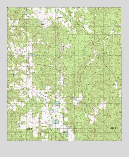
Nymph, AL USGS Topographic Map
Click on map above to begin viewing in our Map Viewer.

This topographic map contains these locations and features:
Feature Name Type Latitude Longitude GNIS ID View Map
Albrest CemeteryCemeteryN31.2813°W86.9200°149618View Map
Bethel African Methodist Episcopal ChurchChurchN31.3132°W86.9825°133368View Map
Bethel Methodist ChurchChurchN31.3121°W86.9816°133367View Map
Cedar Creek ChurchChurchN31.2891°W86.9269°133101View Map
Covington County CourthouseBuildingN31.3085°W86.9991°133386View Map
Davison CemeteryCemeteryN31.3088°W86.8791°149627View Map
Ed PondLakeN31.2791°W86.9518°133110View Map
Feagin CreekStreamN31.2527°W86.9211°133787View Map
First Christian ChurchChurchN31.3077°W86.9830°133395View Map
First Presbyterian ChurchChurchN31.3060°W86.9833°133399View Map
Greater Nazarene Baptist ChurchChurchN31.3382°W86.9402°133119View Map
Greater Nazarene CemeteryCemeteryN31.3379°W86.9394°1805740View Map
Holly Grove CemeteryCemeteryN31.3002°W86.9816°1730211View Map
Jay VillaPopulated PlaceN31.3654°W86.9455°133129View Map
L PondLakeN31.2677°W86.9478°163934View Map
L Pond ChurchChurchN31.2796°W86.9550°133132View Map
L Pond ChurchChurchN31.2896°W86.9536°133133View Map
Little Cedar CreekStreamN31.2707°W86.9230°155326View Map
McMillan DamDamN31.3611°W86.9661°129784View Map
McMillan PondReservoirN31.3611°W86.9617°154077View Map
Mount Olive ChurchChurchN31.3496°W86.8872°149646View Map
New Beulah ChurchChurchN31.3546°W86.8839°133153View Map
New Hope CemeteryCemeteryN31.3416°W86.9677°149651View Map
New Hope ChurchChurchN31.3460°W86.9733°133155View Map
NymphPopulated PlaceN31.3382°W86.9397°133158View Map
Nymph Volunteer Fire DepartmentBuildingN31.3103°W86.9417°2691129View Map
Old Beulah CemeteryCemeteryN31.3521°W86.9216°133159View Map
Old Country Club DamDamN31.3618°W86.9283°129783View Map
Old Country Club PondReservoirN31.3650°W86.9303°129782View Map
Old SpartaPopulated PlaceN31.3629°W86.9872°133160View Map
Saint Luke ChurchChurchN31.3104°W86.9411°133181View Map
Shipps PondLakeN31.2850°W86.9467°126776View Map
Sparta CemeteryCemeteryN31.3504°W86.9886°149669View Map
Sparta Hill CemeteryCemeteryN31.3341°W86.9861°1805521View Map
Sparta Hill Methodist ChurchChurchN31.3343°W86.9864°149670View Map
Union Grove ChurchChurchN31.2913°W86.9264°133195View Map
Weaver PondLakeN31.2646°W86.9511°133199View Map

Note: Coordinates in the location and feature list above are referenced to NAD83 datum.


Copyright (C) 2008-2025 Ryan Niemi / Sunset Dynamics ... All Rights Reserved