TopoQuest Logo
Do you find TopoQuest useful?
Help keep TopoQuest running and adding new maps/features by donating!
Bitcoin:  19c7KJd3qBynnjoSw5npx9KScwjBe4ifkT
Litecoin:  LXs6TkuXGGXo1vDsWCkWVdjQX94eUKd6ui
Home View Maps Find Maps Find Places Resources & Links


Belleville, Alabama Topographic Map

USGS Map Title: Belleville, AL
USGS Map MRC: 31087D1
DRG (GeoTIFF) Download: o31087d1.tif


Neighboring USGS Topographic Map Quads:


  Burnt Corn, AL  
31087E2
 

  China, AL  
31087E1
 

  Lyeffion, AL  
31086E8
 

  Repton, AL  
31087D2
 

  Belleville, AL  
31087D1
 

  Evergreen, AL  
31086D8
 

  Range, AL  
31087C2
 

  Castleberry, AL  
31087C1
 

  Nymph, AL  
31086C8


Map MRC Location:

N32°
W88°
N32°
W87°
H8 H7 H6 H5 H4 H3 H2 H1
G8 G7 G6 G5 G4 G3 G2 G1
F8 F7 F6 F5 F4 F3 F2 F1
E8 E7 E6 E5 E4 E3 E2 E1
D8 D7 D6 D5 D4 D3 D2 D1
C8 C7 C6 C5 C4 C3 C2 C1
B8 B7 B6 B5 B4 B3 B2 B1
A8 A7 A6 A5 A4 A3 A2 A1
N31°
W88°
N31°
W87°

Belleville, AL USGS 1:24K Topographic Map Preview:
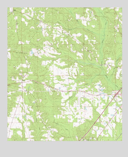
Belleville, AL USGS Topographic Map
Click on map above to begin viewing in our Map Viewer.

This topographic map contains these locations and features:
Feature Name Type Latitude Longitude GNIS ID View Map
Arkadelphia CemeteryCemeteryN31.4746°W87.0575°149619View Map
Arkadelphia ChurchChurchN31.4771°W87.0616°113208View Map
Baggett PondReservoirN31.4803°W87.0874°133086View Map
BellevillePopulated PlaceN31.4299°W87.1091°113883View Map
Belleville CemeteryCemeteryN31.4357°W87.1066°1805606View Map
Belleville ChurchChurchN31.4354°W87.1069°149620View Map
Belleville ChurchChurchN31.4338°W87.1083°149621View Map
Belleville ChurchChurchN31.4293°W87.1108°149622View Map
Belleville Elementary School (historical)SchoolN31.4296°W87.1066°148930View Map
Belleville Fork ChurchChurchN31.4296°W87.0922°113884View Map
Belleville Lookout TowerTowerN31.4574°W87.1078°164283View Map
Belleville Volunteer Fire DepartmentBuildingN31.4294°W87.1086°2691216View Map
Bellview Academy (historical)SchoolN31.4127°W87.1080°133089View Map
Brantley CrossingPopulated PlaceN31.4966°W87.1191°114839View Map
Cane CreekStreamN31.4327°W87.0141°115540View Map
Cenntial ChurchChurchN31.4599°W87.0375°115827View Map
Chappelle ChurchChurchN31.4902°W87.0041°115966View Map
Evergreen Naval Outer Landing Field (historical)MilitaryN31.4189°W87.0475°2571532View Map
Evergreen Regional Airport/Middleton FieldAirportN31.4197°W87.0437°129401View Map
Exit 93CrossingN31.4188°W87.0058°155647View Map
FairviewPopulated PlaceN31.4193°W87.0053°118127View Map
Fairview ChurchChurchN31.4124°W87.0064°149628View Map
Granny BranchStreamN31.4824°W87.0450°119231View Map
Hamden Ridge CemeteryCemeteryN31.3774°W87.0408°149632View Map
Hamden Ridge ChurchChurchN31.3757°W87.0386°149633View Map
Hunter CreekStreamN31.4368°W87.0189°120553View Map
Ivey CemeteryCemeteryN31.4743°W87.0439°149637View Map
LoreePopulated PlaceN31.4874°W87.0900°156629View Map
Otter CreekStreamN31.4421°W87.0214°124322View Map
Rays Bridge (historical)BridgeN31.4235°W87.0014°133177View Map
Riley CemeteryCemeteryN31.4590°W87.0372°149661View Map
Robinson CemeteryCemeteryN31.4804°W87.0080°149662View Map
Rudolph TempleChurchN31.4054°W87.1039°149663View Map
Shack CreekStreamN31.4732°W87.0197°126573View Map
Sparta (historical)LocaleN31.3791°W87.0041°149372View Map
StokesPopulated PlaceN31.4966°W87.0964°133191View Map
Stowers Number One DamDamN31.4235°W87.0216°129819View Map
Stowers Number Three DamDamN31.4285°W87.0233°129820View Map
Stowers Number Two DamDamN31.4202°W87.0200°129815View Map
Stowers Number Two LakeReservoirN31.4194°W87.0221°129814View Map
Stowers PondReservoirN31.4265°W87.0239°154078View Map
W C Allen DamDamN31.4568°W87.0966°129839View Map

Note: Coordinates in the location and feature list above are referenced to NAD83 datum.


Copyright (C) 2008-2024 Ryan Niemi / Sunset Dynamics ... All Rights Reserved