TopoQuest Logo
Do you find TopoQuest useful?
Help keep TopoQuest running and adding new maps/features by donating!
Bitcoin:  19c7KJd3qBynnjoSw5npx9KScwjBe4ifkT
Litecoin:  LXs6TkuXGGXo1vDsWCkWVdjQX94eUKd6ui
Home View Maps Find Maps Find Places Resources & Links


Oatman Flat, Oregon Topographic Map

USGS Map Title: Oatman Flat, OR
USGS Map MRC: 43121B2
DRG (GeoTIFF) Download: o43121b2.tif


Neighboring USGS Topographic Map Quads:


  Wickiup Spring, OR  
43121C3
 

  McCarty Butte, OR  
43121C2
 

  Fort Rock, OR  
43121C1
 

  Antelope Mountain, OR  
43121B3
 

  Oatman Flat, OR  
43121B2
 

  Silver Lake, OR  
43121B1
 

  Rodman Rock, OR  
43121A3
 

  Bridge Creek Draw, OR  
43121A2
 

  Hager Mountain, OR  
43121A1


Map MRC Location:

N44°
W122°
N44°
W121°
H8 H7 H6 H5 H4 H3 H2 H1
G8 G7 G6 G5 G4 G3 G2 G1
F8 F7 F6 F5 F4 F3 F2 F1
E8 E7 E6 E5 E4 E3 E2 E1
D8 D7 D6 D5 D4 D3 D2 D1
C8 C7 C6 C5 C4 C3 C2 C1
B8 B7 B6 B5 B4 B3 B2 B1
A8 A7 A6 A5 A4 A3 A2 A1
N43°
W122°
N43°
W121°

Oatman Flat, OR USGS 1:24K Topographic Map Preview:
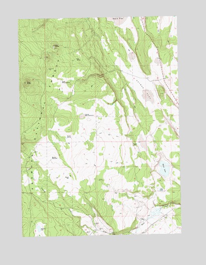
Oatman Flat, OR USGS Topographic Map
Click on map above to begin viewing in our Map Viewer.

This topographic map contains these locations and features:
Feature Name Type Latitude Longitude GNIS ID View Map
Baskin SpringSpringN43.1808°W121.2144°1137570View Map
Deadmond PlaceLocaleN43.1329°W121.1542°1140748View Map
Devils Ball DiamondFlatN43.1937°W121.2022°1140939View Map
Freeman Dry CampLocaleN43.1568°W121.1906°1158230View Map
Halfway LakeLakeN43.1294°W121.2379°1143212View Map
Lily LakeLakeN43.1505°W121.1412°1145011View Map
Logger WaterholeReservoirN43.1757°W121.1929°1153884View Map
Meadow WaterholeLakeN43.1692°W121.2271°1146067View Map
North Willow SpringSpringN43.2134°W121.2181°1147074View Map
Oat ButteSummitN43.2343°W121.2225°1147127View Map
Oatman FlatFlatN43.2071°W121.1522°1147128View Map
R Emery RanchLocaleN43.1260°W121.1617°1155797View Map
Ross SpringSpringN43.2263°W121.2060°1148742View Map
Round ReservoirReservoirN43.1583°W121.2135°1148801View Map
Sears FlatFlatN43.2499°W121.1678°1139546View Map
Shumacher Reservoir Number FiveReservoirN43.2261°W121.1617°1161730View Map
Stratton PlaceLocaleN43.1768°W121.1600°1150475View Map
T Emery RanchLocaleN43.1368°W121.1411°1155794View Map
Ward LakeLakeN43.1623°W121.1384°1151886View Map
Williams Mill (historical)LocaleN43.2387°W121.1872°1153885View Map
Wing ButteSummitN43.2135°W121.2453°1152528View Map
Wing Butte CabinLocaleN43.2210°W121.2278°1152529View Map

Note: Coordinates in the location and feature list above are referenced to NAD83 datum.


Copyright (C) 2008-2024 Ryan Niemi / Sunset Dynamics ... All Rights Reserved