TopoQuest Logo
Do you find TopoQuest useful?
Help keep TopoQuest running and adding new maps/features by donating!
Bitcoin:  19c7KJd3qBynnjoSw5npx9KScwjBe4ifkT
Litecoin:  LXs6TkuXGGXo1vDsWCkWVdjQX94eUKd6ui
Home View Maps Find Maps Find Places Resources & Links


Ogdensburg West, New York Topographic Map

USGS Map Title: Ogdensburg West, NY
USGS Map MRC: 44075F5
DRG (GeoTIFF) Download: o44075f5.tif


Neighboring USGS Topographic Map Quads:


  Red Mills, NY  
44075G4


  Ogdensburg West, NY  
44075F5
 

  Ogdensburg East, NY  
44075F4
 

  Morristown, NY  
44075E6
 

  Edwardsville, NY  
44075E5
 

  Heuvelton, NY  
44075E4


Map MRC Location:

N45°
W76°
N45°
W75°
H8 H7 H6 H5 H4 H3 H2 H1
G8 G7 G6 G5 G4 G3 G2 G1
F8 F7 F6 F5 F4 F3 F2 F1
E8 E7 E6 E5 E4 E3 E2 E1
D8 D7 D6 D5 D4 D3 D2 D1
C8 C7 C6 C5 C4 C3 C2 C1
B8 B7 B6 B5 B4 B3 B2 B1
A8 A7 A6 A5 A4 A3 A2 A1
N44°
W76°
N44°
W75°

Ogdensburg West, NY USGS 1:24K Topographic Map Preview:
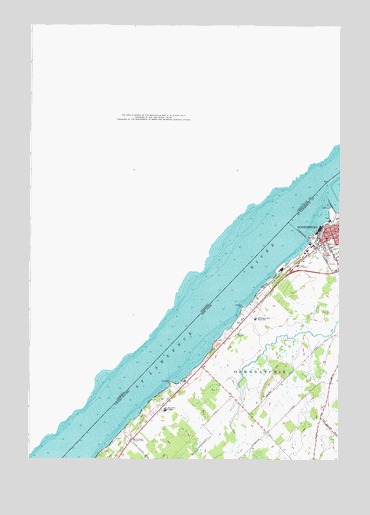
Ogdensburg West, NY USGS Topographic Map
Click on map above to begin viewing in our Map Viewer.

This topographic map contains these locations and features:
Feature Name Type Latitude Longitude GNIS ID View Map
C Way Drive-In (historical)LocaleN44.6611°W75.5419°2558362View Map
Cedars Nursing HomeBuildingN44.6653°W75.5388°975813View Map
Fishel FarmsLocaleN44.6522°W75.5017°2702624View Map
Madill SchoolSchoolN44.6843°W75.5013°2597211View Map
Mater Dei College (historical)SchoolN44.6392°W75.5697°976642View Map
Nevins PointCapeN44.6681°W75.5388°975849View Map
Notre Dame De La Victoire Roman Catholic ChurchChurchN44.6928°W75.5003°2375725View Map
Ogdensburg Country ClubLocaleN44.6309°W75.5838°976760View Map
Pythian HomeBuildingN44.6808°W75.5164°2120467View Map
Saint Joseph's School (historical)SchoolN44.6922°W75.5003°2375726View Map
Saint Lawrence ParkParkN44.6359°W75.5802°975814View Map
Saint Lawrence State Park Golf CourseLocaleN44.6305°W75.5819°2599054View Map
School Number 1 (historical)SchoolN44.6664°W75.5372°2120468View Map
School Number 3 (historical)SchoolN44.6339°W75.5294°2120469View Map
School Number 6 (historical)SchoolN44.6503°W75.5525°2120470View Map
Stillwells PointCapeN44.6467°W75.5673°975848View Map
United Helpers Nursing HomeBuildingN44.6807°W75.5158°2599041View Map
Wadhams Hall SeminarySchoolN44.6656°W75.5336°977175View Map
Washington SchoolSchoolN44.6889°W75.5050°2375731View Map

Note: Coordinates in the location and feature list above are referenced to NAD83 datum.


Copyright (C) 2008-2025 Ryan Niemi / Sunset Dynamics ... All Rights Reserved