TopoQuest Logo
Do you find TopoQuest useful?
Help keep TopoQuest running and adding new maps/features by donating!
Bitcoin:  19c7KJd3qBynnjoSw5npx9KScwjBe4ifkT
Litecoin:  LXs6TkuXGGXo1vDsWCkWVdjQX94eUKd6ui
Home View Maps Find Maps Find Places Resources & Links


Heuvelton, New York Topographic Map

USGS Map Title: Heuvelton, NY
USGS Map MRC: 44075E4
DRG (GeoTIFF) Download: o44075e4.tif


Neighboring USGS Topographic Map Quads:


  Ogdensburg West, NY  
44075F5
 

  Ogdensburg East, NY  
44075F4
 

  Lisbon, NY  
44075F3
 

  Edwardsville, NY  
44075E5
 

  Heuvelton, NY  
44075E4
 

  Rensselaer Falls, NY  
44075E3
 

  Pope Mills, NY  
44075D5
 

  Richville, NY  
44075D4
 

  Bigelow, NY  
44075D3


Map MRC Location:

N45°
W76°
N45°
W75°
H8 H7 H6 H5 H4 H3 H2 H1
G8 G7 G6 G5 G4 G3 G2 G1
F8 F7 F6 F5 F4 F3 F2 F1
E8 E7 E6 E5 E4 E3 E2 E1
D8 D7 D6 D5 D4 D3 D2 D1
C8 C7 C6 C5 C4 C3 C2 C1
B8 B7 B6 B5 B4 B3 B2 B1
A8 A7 A6 A5 A4 A3 A2 A1
N44°
W76°
N44°
W75°

Heuvelton, NY USGS 1:24K Topographic Map Preview:
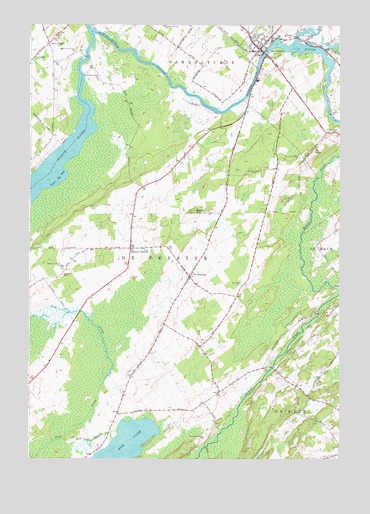
Heuvelton, NY USGS Topographic Map
Click on map above to begin viewing in our Map Viewer.

This topographic map contains these locations and features:
Feature Name Type Latitude Longitude GNIS ID View Map
Barter HillSummitN44.5709°W75.4338°975925View Map
Bittersweet FarmLocaleN44.5314°W75.4897°2559370View Map
Chambers FarmsLocaleN44.5942°W75.4303°2702689View Map
De PeysterPopulated PlaceN44.5526°W75.4355°976224View Map
East Road CemeteryCemeteryN44.5505°W75.4143°976277View Map
Fish Creek School (historical)SchoolN44.5272°W75.4925°2106709View Map
HeuveltonPopulated PlaceN44.6181°W75.4072°976431View Map
Heuvelton Central SchoolSchoolN44.6202°W75.4081°2597198View Map
Heuvelton Free LibraryBuildingN44.6186°W75.4085°2599064View Map
Heuvelton Village Water Pollution Control PlantLocaleN44.6110°W75.4101°2597192View Map
Heuvelton Volunteer Fire DepartmentBuildingN44.6161°W75.4036°2718267View Map
Hillcrest CemeteryCemeteryN44.6234°W75.4041°976439View Map
Kokomo CornersLocaleN44.5603°W75.4591°976526View Map
Lisbon CreekStreamN44.6212°W75.3927°976554View Map
Lost VillagePopulated PlaceN44.6195°W75.4924°976604View Map
Lower Big BayBayN44.5807°W75.4885°976608View Map
Mount LonaSummitN44.5895°W75.3849°976579View Map
Mount Lona CemeteryCemeteryN44.5942°W75.3760°976690View Map
Mud LakeLakeN44.5033°W75.4616°976696View Map
Mud Lake OutletStreamN44.5059°W75.4861°976697View Map
Pine Hill CemeteryCemeteryN44.6214°W75.4909°976820View Map
Purmort CemeteryCemeteryN44.5531°W75.4867°976857View Map
Sand Road CemeteryCemeteryN44.6154°W75.4984°976960View Map
School Number 1 (historical)SchoolN44.5494°W75.4372°2106710View Map
School Number 15 (historical)SchoolN44.6156°W75.4911°2106717View Map
School Number 2 (historical)SchoolN44.5147°W75.4636°2106711View Map
School Number 3 (historical)SchoolN44.5261°W75.4053°2106712View Map
School Number 4 (historical)SchoolN44.5608°W75.4594°2106713View Map
School Number 5 (historical)SchoolN44.5853°W75.4406°2106714View Map
School Number 6 (historical)SchoolN44.5742°W75.4039°2106715View Map
School Number 9 (historical)SchoolN44.5706°W75.4233°2106716View Map
Spile Bridge Road BridgeBridgeN44.6155°W75.4770°2614994View Map
Town of De PeysterCivilN44.5497°W75.4573°978898View Map
Village of HeuveltonCivilN44.6170°W75.4046°2390892View Map
Wesleyan ChurchChurchN44.6202°W75.4081°2597616View Map

Note: Coordinates in the location and feature list above are referenced to NAD83 datum.


Copyright (C) 2008-2025 Ryan Niemi / Sunset Dynamics ... All Rights Reserved