TopoQuest Logo
Do you find TopoQuest useful?
Help keep TopoQuest running and adding new maps/features by donating!
Bitcoin:  19c7KJd3qBynnjoSw5npx9KScwjBe4ifkT
Litecoin:  LXs6TkuXGGXo1vDsWCkWVdjQX94eUKd6ui
Home View Maps Find Maps Find Places Resources & Links


Olanta, South Carolina Topographic Map

USGS Map Title: Olanta, SC
USGS Map MRC: 33079H8
DRG (GeoTIFF) Download: o33079h8.tif


Neighboring USGS Topographic Map Quads:


  Lynchburg, SC  
34080A1
 

  Sardis, SC  
34079A8
 

  Effingham, SC  
34079A7
 

  Turbeville, SC  
33080H1
 

  Olanta, SC  
33079H8
 

  Mill Bay, SC  
33079H7
 

  Sardinia, SC  
33080G1
 

  Hebron Crossroads, SC  
33079G8
 

  Lake City West, SC  
33079G7


Map MRC Location:

N34°
W80°
N34°
W79°
H8 H7 H6 H5 H4 H3 H2 H1
G8 G7 G6 G5 G4 G3 G2 G1
F8 F7 F6 F5 F4 F3 F2 F1
E8 E7 E6 E5 E4 E3 E2 E1
D8 D7 D6 D5 D4 D3 D2 D1
C8 C7 C6 C5 C4 C3 C2 C1
B8 B7 B6 B5 B4 B3 B2 B1
A8 A7 A6 A5 A4 A3 A2 A1
N33°
W80°
N33°
W79°

Olanta, SC USGS 1:24K Topographic Map Preview:
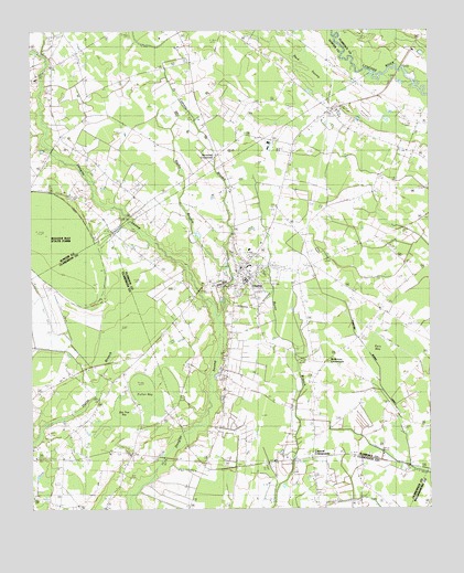
Olanta, SC USGS Topographic Map
Click on map above to begin viewing in our Map Viewer.

This topographic map contains these locations and features:
Feature Name Type Latitude Longitude GNIS ID View Map
Back SwampSwampN33.9867°W79.9131°1220278View Map
Bee Tree BaySwampN33.9010°W79.9708°1220460View Map
Bethany CemeteryCemeteryN33.9946°W79.8820°1220524View Map
Bethel CemeteryCemeteryN33.9793°W79.9031°1242312View Map
Bethel ChurchChurchN33.9790°W79.9040°1220560View Map
Bethel SchoolSchoolN33.9699°W79.8901°1220586View Map
Beulah Mission ChurchChurchN33.9343°W79.9051°1220645View Map
Bushy BranchStreamN33.9246°W79.9417°1221156View Map
Byrd FieldAirportN33.8883°W79.9988°1251981View Map
Central CrossroadsPopulated PlaceN33.8879°W79.9128°1247237View Map
Central School (historical)SchoolN33.8885°W79.9117°1241812View Map
Cypress BranchStreamN33.9374°W79.9384°1221896View Map
Fuller BaySwampN33.9058°W79.9649°1222601View Map
Jerusalem ChurchChurchN33.8896°W79.9023°1241982View Map
Jordan Chapel Baptist ChurchChurchN33.9543°W79.9228°1241989View Map
McKenzie CrossroadsPopulated PlaceN33.9132°W79.9084°1246598View Map
Mimms CrossroadsPopulated PlaceN33.9390°W79.9115°1242059View Map
Motts CrossroadsPopulated PlaceN33.9788°W79.9053°1242065View Map
New Jerusalem School (historical)SchoolN33.8893°W79.9031°1249838View Map
New Town CemeteryCemeteryN33.8846°W79.9173°1235980View Map
New Town ChurchChurchN33.8843°W79.9176°1249855View Map
Norwood CrossroadPopulated PlaceN33.9679°W79.9415°1249903View Map
Oak Grove ChurchChurchN33.8899°W79.9753°1235984View Map
Oak Grove ChurchChurchN33.8774°W79.9495°1235985View Map
Oak Grove SchoolSchoolN33.8777°W79.9506°1225119View Map
OlantaPopulated PlaceN33.9354°W79.9326°1249947View Map
Olanta CemeteryCemeteryN33.9377°W79.9348°1242105View Map
Olanta DivisionCivilN33.9333°W79.8766°1938371View Map
Olanta Elementary SchoolSchoolN33.9385°W79.9317°1242106View Map
Olanta First Pentecostal Holiness ChurchChurchN33.9254°W79.9291°1241969View Map
Olanta Police DepartmentBuildingN33.9380°W79.9281°2334956View Map
Olanta Post OfficePost OfficeN33.9381°W79.9338°1252266View Map
Olanta Presbyterian ChurchChurchN33.9371°W79.9353°1242104View Map
Olanta Public LibraryBuildingN33.9382°W79.9270°2490384View Map
Olanta Rural Fire DepartmentBuildingN33.9374°W79.9079°2368129View Map
Pats BayBasinN33.9163°W79.8865°1225320View Map
Pine Dale School (historical)SchoolN33.8896°W79.9690°1248761View Map
Rush CemeteryCemeteryN33.8999°W79.9417°1226075View Map
Saint John SchoolSchoolN33.9890°W79.9953°1226137View Map
Saint Johns ChurchChurchN33.9902°W79.9951°1244676View Map
Saint Johns SchoolSchoolN33.9877°W79.9981°1244677View Map
Saint Mark ChurchChurchN33.9968°W79.9320°1244684View Map
Saint Mark SchoolSchoolN33.9965°W79.9331°1226185View Map
Sumter Fire Department Byrds Station 18BuildingN33.9840°W79.9925°2578387View Map
Town of OlantaCivilN33.9357°W79.9320°2407042View Map
Union Hill ChurchChurchN33.8910°W79.9995°1251785View Map
Union Hill ChurchChurchN33.9038°W79.9790°1236062View Map
Union Hill SchoolSchoolN33.9035°W79.9792°1227304View Map
Welsh BridgeBridgeN33.9902°W79.8837°1242237View Map
Woods Bay State ParkParkN33.9460°W79.9928°1244778View Map
Woods MillpondSwampN33.9442°W79.9918°1227703View Map
Zion ChurchChurchN33.9752°W79.9453°1251549View Map

Note: Coordinates in the location and feature list above are referenced to NAD83 datum.


Copyright (C) 2008-2025 Ryan Niemi / Sunset Dynamics ... All Rights Reserved