TopoQuest Logo
Do you find TopoQuest useful?
Help keep TopoQuest running and adding new maps/features by donating!
Bitcoin:  19c7KJd3qBynnjoSw5npx9KScwjBe4ifkT
Litecoin:  LXs6TkuXGGXo1vDsWCkWVdjQX94eUKd6ui
Home View Maps Find Maps Find Places Resources & Links


Turbeville, South Carolina Topographic Map

USGS Map Title: Turbeville, SC
USGS Map MRC: 33080H1
DRG (GeoTIFF) Download: o33080h1.tif


Neighboring USGS Topographic Map Quads:


  Elliott, SC  
34080A2
 

  Lynchburg, SC  
34080A1
 

  Sardis, SC  
34079A8
 

  Mayesville, SC  
33080H2
 

  Turbeville, SC  
33080H1
 

  Olanta, SC  
33079H8
 

  Tearcoat Branch, SC  
33080G2
 

  Sardinia, SC  
33080G1
 

  Hebron Crossroads, SC  
33079G8


Map MRC Location:

N34°
W81°
N34°
W80°
H8 H7 H6 H5 H4 H3 H2 H1
G8 G7 G6 G5 G4 G3 G2 G1
F8 F7 F6 F5 F4 F3 F2 F1
E8 E7 E6 E5 E4 E3 E2 E1
D8 D7 D6 D5 D4 D3 D2 D1
C8 C7 C6 C5 C4 C3 C2 C1
B8 B7 B6 B5 B4 B3 B2 B1
A8 A7 A6 A5 A4 A3 A2 A1
N33°
W81°
N33°
W80°

Turbeville, SC USGS 1:24K Topographic Map Preview:
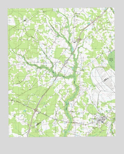
Turbeville, SC USGS Topographic Map
Click on map above to begin viewing in our Map Viewer.

This topographic map contains these locations and features:
Feature Name Type Latitude Longitude GNIS ID View Map
Asbury CemeteryCemeteryN33.9563°W80.0403°1244441View Map
Asbury ChurchChurchN33.9618°W80.0420°1244928View Map
Asbury School (historical)SchoolN33.9607°W80.0426°1244442View Map
Beulah ChurchChurchN33.9443°W80.1209°1220641View Map
Clarendon Fire Department Station 2BuildingN33.8913°W80.0177°2368089View Map
Cowbay SwampSwampN33.9310°W80.1120°1221796View Map
Dennis Memorial AuditoriumBuildingN33.8999°W80.0520°1235911View Map
Dial BaySwampN33.9232°W80.0073°1222012View Map
East Clarendon High SchoolSchoolN33.8921°W80.0151°1235916View Map
East Clarendon SchoolSchoolN33.8929°W80.0145°1235918View Map
Faith Bible ChurchChurchN33.9854°W80.0048°1244517View Map
Free Will Baptist Childrens HomeBuildingN33.8935°W80.0098°1235929View Map
Friendship ChurchChurchN33.9813°W80.0476°1244531View Map
Hickory Grove ChurchChurchN33.8799°W80.0173°1235941View Map
Hickory Grove School (historical)SchoolN33.8796°W80.0167°1235942View Map
Holiness ChurchChurchN33.9021°W80.0509°1223223View Map
Hope SwampStreamN33.9335°W80.0487°1223278View Map
Hudgens AcademySchoolN33.9677°W80.0448°1244569View Map
Interchange 135CrossingN33.9013°W80.0931°1228322View Map
Interchange 141CrossingN33.9693°W80.0417°1228323View Map
Johnson School (historical)SchoolN33.9513°W80.0654°1244579View Map
Mount Sinai ChurchChurchN33.9482°W80.0645°1250901View Map
Mount Sinai School (historical)SchoolN33.9777°W80.0717°1244613View Map
Mount Sinai School (historical)SchoolN33.9727°W80.0673°1244614View Map
Muldrow School (historical)SchoolN33.9446°W80.1209°1244617View Map
Oak Grove ChurchChurchN33.9102°W80.0487°1235986View Map
Pineland Plantation Golf ClubLocaleN33.9098°W80.0970°2490046View Map
Pleasant GrovePopulated PlaceN33.9918°W80.0459°1244646View Map
Pleasant Grove ChurchChurchN33.9896°W80.0467°1244647View Map
Pleasant Grove SchoolSchoolN33.9943°W80.0456°1225540View Map
Plum Hill School (historical)SchoolN33.9188°W80.0554°1244648View Map
Plumhaw SchoolSchoolN33.9399°W80.0798°1225565View Map
Rose Hill ChurchChurchN33.9868°W80.0815°1226025View Map
Rose Hill School (historical)SchoolN33.9863°W80.0812°1244662View Map
SelocPopulated PlaceN33.8813°W80.0084°1231790View Map
ShilohPopulated PlaceN33.9402°W80.0409°1226563View Map
Shiloh CemeteryCemeteryN33.9402°W80.0401°1244699View Map
Shiloh Census Designated PlaceCensusN33.9463°W80.0206°2402850View Map
Shiloh ChurchChurchN33.9399°W80.0404°1244700View Map
Shiloh DivisionCivilN33.9570°W80.0535°1938421View Map
South Carolina Noname 14006 D-3481 DamDamN33.8885°W80.0015°1238627View Map
Sumter Fire Department Pleasant Grove Station 4BuildingN33.9827°W80.0479°2578368View Map
Sunnyside SchoolSchoolN33.9090°W80.0654°1226967View Map
Threemile BranchStreamN33.9424°W80.0729°1251167View Map
Town of TurbevilleCivilN33.8895°W80.0162°2406766View Map
Trinity ChurchChurchN33.9746°W80.0667°1251209View Map
Trinity Church (historical)ChurchN33.9418°W80.0395°1244752View Map
Trinity Cross RoadsPopulated PlaceN33.9668°W80.0706°1244753View Map
TurbevillePopulated PlaceN33.8907°W80.0184°1251230View Map
Turbeville Correctional InstitutionBuildingN33.8871°W80.0821°2489671View Map
Turbeville Correctional Institution InfirmaryHospitalN33.8939°W80.0780°2640009View Map
Turbeville Police DepartmentBuildingN33.8896°W80.0198°2334894View Map
Turbeville Post OfficePost OfficeN33.8898°W80.0248°1252205View Map
Turbeville Town HallBuildingN33.8915°W80.0176°1236060View Map

Note: Coordinates in the location and feature list above are referenced to NAD83 datum.


Copyright (C) 2008-2025 Ryan Niemi / Sunset Dynamics ... All Rights Reserved