TopoQuest Logo
Do you find TopoQuest useful?
Help keep TopoQuest running and adding new maps/features by donating!
Bitcoin:  19c7KJd3qBynnjoSw5npx9KScwjBe4ifkT
Litecoin:  LXs6TkuXGGXo1vDsWCkWVdjQX94eUKd6ui
Home View Maps Find Maps Find Places Resources & Links


Lynchburg, South Carolina Topographic Map

USGS Map Title: Lynchburg, SC
USGS Map MRC: 34080A1
DRG (GeoTIFF) Download: o34080a1.tif


Neighboring USGS Topographic Map Quads:


  Bishopville East, SC  
34080B2
 

  Lamar, SC  
34080B1
 

  Timmonsville, SC  
34079B8
 

  Elliott, SC  
34080A2
 

  Lynchburg, SC  
34080A1
 

  Sardis, SC  
34079A8
 

  Mayesville, SC  
33080H2
 

  Turbeville, SC  
33080H1
 

  Olanta, SC  
33079H8


Map MRC Location:

N35°
W81°
N35°
W80°
H8 H7 H6 H5 H4 H3 H2 H1
G8 G7 G6 G5 G4 G3 G2 G1
F8 F7 F6 F5 F4 F3 F2 F1
E8 E7 E6 E5 E4 E3 E2 E1
D8 D7 D6 D5 D4 D3 D2 D1
C8 C7 C6 C5 C4 C3 C2 C1
B8 B7 B6 B5 B4 B3 B2 B1
A8 A7 A6 A5 A4 A3 A2 A1
N34°
W81°
N34°
W80°

Lynchburg, SC USGS 1:24K Topographic Map Preview:
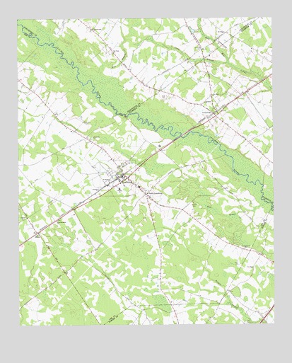
Lynchburg, SC USGS Topographic Map
Click on map above to begin viewing in our Map Viewer.

This topographic map contains these locations and features:
Feature Name Type Latitude Longitude GNIS ID View Map
AtkinsPopulated PlaceN34.0379°W80.1154°1220263View Map
Back SwampStreamN34.0493°W80.0028°1220277View Map
Bethesda ChurchChurchN34.0554°W80.0856°1246812View Map
Byrds Ferry (historical)CrossingN34.0857°W80.0723°1236901View Map
Camel BranchStreamN34.1065°W80.0212°1221230View Map
Campground CemeteryCemeteryN34.0307°W80.0140°1221283View Map
CartersvillePopulated PlaceN34.0863°W80.0287°1231138View Map
Cartersville Baptist ChurchChurchN34.0829°W80.0245°1242347View Map
Cartersville School (historical)SchoolN34.0904°W80.0381°1242348View Map
Durants Ferry (historical)CrossingN34.0693°W80.0234°1251803View Map
Evening Light ChurchChurchN34.1207°W80.0876°1222310View Map
Fair Hope ChurchChurchN34.1110°W80.0776°1222332View Map
Field CemeteryCemeteryN34.0921°W80.0528°1222384View Map
Fleming SchoolSchoolN34.0554°W80.0751°1247777View Map
Green Bay ChurchChurchN34.0765°W80.0876°1245823View Map
Hawkins CemeteryCemeteryN34.0496°W80.0390°1223088View Map
Holiness Church (historical)ChurchN34.0396°W80.1120°1245665View Map
King Emmanuel ChurchChurchN34.0427°W80.1062°1246246View Map
Lee County Fire Department Station 2 - LynchburgBuildingN34.0568°W80.0659°2578661View Map
LynchburgPopulated PlaceN34.0602°W80.0715°1246492View Map
Lynchburg DivisionCivilN34.0395°W80.1095°1938339View Map
Lynchburg Presbyterian Church (historical)ChurchN34.0552°W80.0637°1706225View Map
Macedonia ChurchChurchN34.0910°W80.0328°1224250View Map
Mathis School (historical)SchoolN34.0413°W80.0587°1236930View Map
Mount Tabor ChurchChurchN34.1190°W80.0231°1224800View Map
New Haven ChurchChurchN34.0935°W80.0295°1249803View Map
Rose BranchStreamN34.1010°W80.0787°1226016View Map
Saint Johns ChurchChurchN34.0232°W80.0101°1226154View Map
Saint Matthews ChurchChurchN34.0585°W80.0801°1250627View Map
Saint Paul ChurchChurchN34.1124°W80.0342°1240981View Map
Saint Pauls CemeteryCemeteryN34.1129°W80.0342°1226238View Map
Sanders Bridge (historical)BridgeN34.0857°W80.0723°1236961View Map
Sanders CemeteryCemeteryN34.0829°W80.0920°1226341View Map
Sardis - Timmonsville Fire Department Station 2BuildingN34.0982°W80.0060°2737358View Map
South LynchburgPopulated PlaceN34.0524°W80.0609°1226763View Map
Tolson FarmsLocaleN34.0850°W80.1122°2710698View Map
Town of LynchburgCivilN34.0600°W80.0770°2406064View Map

Note: Coordinates in the location and feature list above are referenced to NAD83 datum.


Copyright (C) 2008-2024 Ryan Niemi / Sunset Dynamics ... All Rights Reserved