TopoQuest Logo
Do you find TopoQuest useful?
Help keep TopoQuest running and adding new maps/features by donating!
Bitcoin:  19c7KJd3qBynnjoSw5npx9KScwjBe4ifkT
Litecoin:  LXs6TkuXGGXo1vDsWCkWVdjQX94eUKd6ui
Home View Maps Find Maps Find Places Resources & Links


Olar, South Carolina Topographic Map

USGS Map Title: Olar, SC
USGS Map MRC: 33081B2
DRG (GeoTIFF) Download: o33081b2.tif


Neighboring USGS Topographic Map Quads:


  Blackville, SC  
33081C3
 

  Denmark, SC  
33081C2
 

  Bamberg, SC  
33081C1
 

  Barnwell, SC  
33081B3
 

  Olar, SC  
33081B2
 

  Clear Pond, SC  
33081B1
 

  Allendale, SC  
33081A3
 

  Sycamore, SC  
33081A2
 

  Ehrhardt, SC  
33081A1


Map MRC Location:

N34°
W82°
N34°
W81°
H8 H7 H6 H5 H4 H3 H2 H1
G8 G7 G6 G5 G4 G3 G2 G1
F8 F7 F6 F5 F4 F3 F2 F1
E8 E7 E6 E5 E4 E3 E2 E1
D8 D7 D6 D5 D4 D3 D2 D1
C8 C7 C6 C5 C4 C3 C2 C1
B8 B7 B6 B5 B4 B3 B2 B1
A8 A7 A6 A5 A4 A3 A2 A1
N33°
W82°
N33°
W81°

Olar, SC USGS 1:24K Topographic Map Preview:
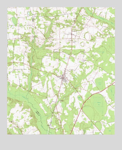
Olar, SC USGS Topographic Map
Click on map above to begin viewing in our Map Viewer.

This topographic map contains these locations and features:
Feature Name Type Latitude Longitude GNIS ID View Map
Allens Chapel Baptist ChurchChurchN33.1324°W81.2409°1235404View Map
Alligator BaySwampN33.1552°W81.1432°1220171View Map
Barbers Branch SchoolSchoolN33.1879°W81.2337°1220320View Map
Bethel ChurchChurchN33.1818°W81.1893°1230878View Map
Bethlehem Baptist ChurchChurchN33.1579°W81.1876°1230879View Map
Birds BranchStreamN33.1374°W81.2107°1246892View Map
Chitty PondSwampN33.1611°W81.1659°1706320View Map
Cypress PondSwampN33.1752°W81.1419°1230895View Map
Duck Pond BaySwampN33.2454°W81.2354°1222132View Map
Eubanks Pond Dam D-2820DamN33.2368°W81.1498°1239665View Map
First Baptist ChurchChurchN33.1835°W81.1857°1230914View Map
Georges CreekStreamN33.1608°W81.2278°1222675View Map
Georges Creek Baptist ChurchChurchN33.2202°W81.2018°1247886View Map
GovanPopulated PlaceN33.2224°W81.1762°1222786View Map
Govan Baptist ChurchChurchN33.2268°W81.1743°1230927View Map
Govan Fire Department Station 5BuildingN33.2193°W81.1760°2368246View Map
Govan Post OfficePost OfficeN33.2238°W81.1745°1252070View Map
Govan School (historical)SchoolN33.2335°W81.1790°1230928View Map
Hercules CreekStreamN33.1665°W81.2493°1223121View Map
Holiness ChurchChurchN33.1840°W81.1823°1230933View Map
Horsepen BaySwampN33.2038°W81.1404°1223332View Map
Juniper BranchStreamN33.2090°W81.2187°1223686View Map
Long PondSwampN33.2115°W81.1273°1224180View Map
Memorial Baptist ChurchChurchN33.1979°W81.1598°1230954View Map
Midok Place School (historical)SchoolN33.2318°W81.1562°1230955View Map
Nimmons CemeteryCemeteryN33.2174°W81.1757°1252071View Map
Oak Grove SchoolSchoolN33.2177°W81.2459°1225116View Map
OlarPopulated PlaceN33.1804°W81.1854°1249948View Map
Olar DivisionCivilN33.1722°W81.1534°1938372View Map
Olar Fire Department Station 8BuildingN33.1807°W81.1862°2368329View Map
Olar Post OfficePost OfficeN33.1803°W81.1849°2489868View Map
Olar School (historical)SchoolN33.1715°W81.1748°1230965View Map
Rosemary Baptist ChurchChurchN33.1379°W81.2457°1235602View Map
Rosemary SchoolSchoolN33.1396°W81.2462°1226029View Map
Rushes Mill (historical)LocaleN33.1677°W81.2248°1230976View Map
Saint Phillip ChurchChurchN33.2157°W81.1729°1230978View Map
SchofieldPopulated PlaceN33.1327°W81.1998°1231781View Map
Starr CemeteryCemeteryN33.1890°W81.1748°1230986View Map
Sweet Branch Baptist ChurchChurchN33.2204°W81.2198°1251087View Map
Sweet Branch School (historical)SchoolN33.2396°W81.2279°1235559View Map
Town of GovanCivilN33.2228°W81.1748°2406596View Map
Town of OlarCivilN33.1799°W81.1853°2407043View Map

Note: Coordinates in the location and feature list above are referenced to NAD83 datum.


Copyright (C) 2008-2025 Ryan Niemi / Sunset Dynamics ... All Rights Reserved