TopoQuest Logo
Do you find TopoQuest useful?
Help keep TopoQuest running and adding new maps/features by donating!
Bitcoin:  19c7KJd3qBynnjoSw5npx9KScwjBe4ifkT
Litecoin:  LXs6TkuXGGXo1vDsWCkWVdjQX94eUKd6ui
Home View Maps Find Maps Find Places Resources & Links


Olive Hill, North Carolina Topographic Map

USGS Map Title: Olive Hill, NC
USGS Map MRC: 36079D1
DRG (GeoTIFF) Download: o36079d1.tif


Neighboring USGS Topographic Map Quads:


  Milton, NC  
36079E2
 

  Alton, VA  
36079E1
 

  Cluster Springs, VA  
36078E8
 

  Leasburg, NC  
36079D2
 

  Olive Hill, NC  
36079D1
 

  Roxboro, NC  
36078D8
 

  Ridgeville, NC  
36079C2
 

  Hurdle Mills, NC  
36079C1
 

  Timberlake, NC  
36078C8


Map MRC Location:

N37°
W80°
N37°
W79°
H8 H7 H6 H5 H4 H3 H2 H1
G8 G7 G6 G5 G4 G3 G2 G1
F8 F7 F6 F5 F4 F3 F2 F1
E8 E7 E6 E5 E4 E3 E2 E1
D8 D7 D6 D5 D4 D3 D2 D1
C8 C7 C6 C5 C4 C3 C2 C1
B8 B7 B6 B5 B4 B3 B2 B1
A8 A7 A6 A5 A4 A3 A2 A1
N36°
W80°
N36°
W79°

Olive Hill, NC USGS 1:24K Topographic Map Preview:
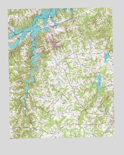
Olive Hill, NC USGS Topographic Map
Click on map above to begin viewing in our Map Viewer.

This topographic map contains these locations and features:
Feature Name Type Latitude Longitude GNIS ID View Map
C P and L Ash PondDamN36.4818°W79.0664°1000676View Map
C P and L Ash PondReservoirN36.4832°W79.0689°1000677View Map
CeffoPopulated PlaceN36.4571°W79.0464°982910View Map
Ceffo Volunteer Fire DepartmentBuildingN36.4568°W79.0474°2638489View Map
Chub LakeReservoirN36.4520°W79.0076°983182View Map
Chub LakePopulated PlaceN36.4510°W79.0025°1966816View Map
Chub Lake DamDamN36.4574°W79.0050°1000653View Map
Cobbs CreekStreamN36.4779°W79.1050°983318View Map
ConcordPopulated PlaceN36.4460°W79.0664°983425View Map
Concord Methodist Church CemeteryCemeteryN36.4462°W79.0675°1966674View Map
Concord United Methodist ChurchChurchN36.4457°W79.0675°1966817View Map
Cub CreekStreamN36.4085°W79.1067°983824View Map
Dunnaways Bridge (historical)BridgeN36.4913°W79.0775°1966692View Map
Five ForksPopulated PlaceN36.4374°W79.0200°1020261View Map
Hedgepeth PondReservoirN36.3832°W79.0556°1000572View Map
Hedgepeth Pond DamDamN36.3835°W79.0564°1000573View Map
Hicks VillagePopulated PlaceN36.4051°W79.0220°986728View Map
Hyco CreekStreamN36.4829°W79.0947°987305View Map
Hyco LakeReservoirN36.4769°W79.1026°987306View Map
Hyco Zion Baptist ChurchChurchN36.4446°W79.0831°987308View Map
Lake ViewPopulated PlaceN36.4001°W79.0025°1005155View Map
Lamberth Memorial Baptist ChurchChurchN36.4088°W79.0603°988114View Map
Lamberth Memorial Baptist Church CemeteryCemeteryN36.4087°W79.0611°1966678View Map
Leas Chapel United Methodist ChurchChurchN36.3838°W79.0947°988257View Map
Lick BranchStreamN36.4274°W79.0192°988441View Map
Little Duck CreekStreamN36.4479°W79.0931°988626View Map
Longs StorePopulated PlaceN36.4140°W79.0781°1021287View Map
Mill Hill ChurchChurchN36.4043°W79.0764°989970View Map
Mount Zion ChurchChurchN36.4646°W79.0131°990679View Map
Oak Grove Methodist Church CemeteryCemeteryN36.4629°W79.0186°1966681View Map
Oak Grove United Methodist ChurchChurchN36.4632°W79.0178°991404View Map
Olive HillPopulated PlaceN36.4246°W79.0495°991643View Map
Olive Hill School (historical)SchoolN36.4218°W79.0464°1966702View Map
Person County Farm (historical)LocaleN36.4218°W79.0006°1966695View Map
Richland CreekStreamN36.4249°W79.1036°993319View Map
Roxboro City LakeReservoirN36.4351°W79.0164°1000620View Map
Roxboro LakeReservoirN36.4269°W79.0177°993780View Map
Roxboro Municipal Lake DamDamN36.4351°W79.0164°1000621View Map
Sargents CreekStreamN36.4899°W79.0806°994350View Map
Satterfield CreekStreamN36.4235°W79.0175°994363View Map
South Hyco CreekStreamN36.4829°W79.0950°995167View Map
Stories Creek Church CemeteryCemeteryN36.4251°W79.0036°1966685View Map
Storys Creek ChurchChurchN36.4249°W79.0036°995589View Map
Township of CunninghamCivilN36.4975°W79.0787°1027046View Map
Township of Olive HillCivilN36.3943°W79.0915°1027050View Map
Wagstaff PondReservoirN36.4378°W79.0685°1000625View Map
Wagstaff Pond DamDamN36.4385°W79.0697°1000624View Map
Wagstaff Store (historical)LocaleN36.4076°W79.0714°1966696View Map
Westwood Baptist ChurchChurchN36.3910°W79.0025°997089View Map
WilliamsvillePopulated PlaceN36.4449°W79.1092°1966704View Map
Woodland SchoolSchoolN36.4624°W79.0825°997593View Map
Zion Level Baptist ChurchChurchN36.4924°W79.1042°997807View Map
Zion Level Baptist Church CemeteryCemeteryN36.4921°W79.1033°1966689View Map

Note: Coordinates in the location and feature list above are referenced to NAD83 datum.


Copyright (C) 2008-2024 Ryan Niemi / Sunset Dynamics ... All Rights Reserved