TopoQuest Logo
Do you find TopoQuest useful?
Help keep TopoQuest running and adding new maps/features by donating!
Bitcoin:  19c7KJd3qBynnjoSw5npx9KScwjBe4ifkT
Litecoin:  LXs6TkuXGGXo1vDsWCkWVdjQX94eUKd6ui
Home View Maps Find Maps Find Places Resources & Links


Cluster Springs, Virginia Topographic Map

USGS Map Title: Cluster Springs, VA
USGS Map MRC: 36078E8
DRG (GeoTIFF) Download: o36078e8.tif


Neighboring USGS Topographic Map Quads:


  Oak Level, VA  
36079F1
 

  South Boston, VA  
36078F8
 

  Omega, VA  
36078F7
 

  Alton, VA  
36079E1
 

  Cluster Springs, VA  
36078E8
 

  Virgilina, VA  
36078E7
 

  Olive Hill, NC  
36079D1
 

  Roxboro, NC  
36078D8
 

  Triple Springs, NC  
36078D7


Map MRC Location:

N37°
W79°
N37°
W78°
H8 H7 H6 H5 H4 H3 H2 H1
G8 G7 G6 G5 G4 G3 G2 G1
F8 F7 F6 F5 F4 F3 F2 F1
E8 E7 E6 E5 E4 E3 E2 E1
D8 D7 D6 D5 D4 D3 D2 D1
C8 C7 C6 C5 C4 C3 C2 C1
B8 B7 B6 B5 B4 B3 B2 B1
A8 A7 A6 A5 A4 A3 A2 A1
N36°
W79°
N36°
W78°

Cluster Springs, VA USGS 1:24K Topographic Map Preview:
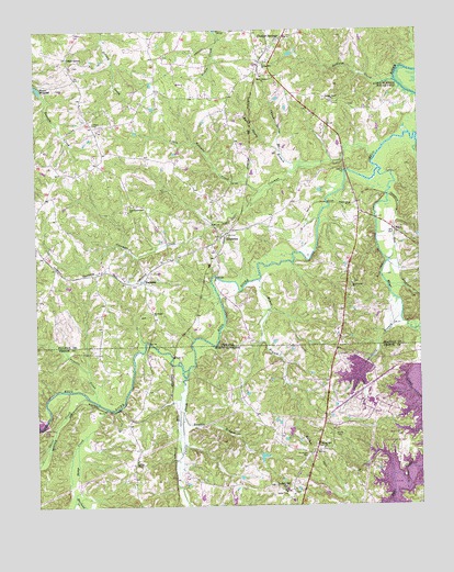
Cluster Springs, VA USGS Topographic Map
Click on map above to begin viewing in our Map Viewer.

This topographic map contains these locations and features:
Feature Name Type Latitude Longitude GNIS ID View Map
Baileys Chapel Methodist ChurchChurchN36.5121°W78.9672°980438View Map
Baileys Chapel Methodist Church CemeteryCemeteryN36.5121°W78.9675°1966670View Map
Bales Spring BranchStreamN36.5901°W78.9067°1462722View Map
Bamboo BranchStreamN36.5243°W78.9522°980512View Map
Bethel HillPopulated PlaceN36.5046°W78.9170°1019111View Map
Bethel HillSummitN36.5124°W78.9095°1019112View Map
Bethel Hill Baptist ChurchChurchN36.5151°W78.9064°981181View Map
Bethel Hill Baptist Church CemeteryCemeteryN36.5153°W78.9071°1966671View Map
Bethel Hill Elementary SchoolSchoolN36.5043°W78.9186°1006748View Map
Bethel Hill High SchoolSchoolN36.5043°W78.9189°1966699View Map
Black Walnut CemeteryCemeteryN36.6132°W78.9264°1690100View Map
Black Walnut ChurchChurchN36.6126°W78.9261°1463513View Map
Blanes Mill DamDamN36.6085°W78.9981°1489978View Map
Blanes MillpondReservoirN36.6100°W78.9987°1463558View Map
Bowes BranchStreamN36.5596°W78.9270°981772View Map
Castle CreekStreamN36.5360°W78.9506°982738View Map
Cedar GrovePopulated PlaceN36.6179°W78.9897°1477192View Map
Cedar Grove CemeteryCemeteryN36.6160°W78.9870°1690104View Map
Cedar Grove United Methodist ChurchChurchN36.6157°W78.9875°1690105View Map
Church Spring BranchStreamN36.5921°W78.9195°1464920View Map
Cluster SpringsPopulated PlaceN36.6210°W78.9217°1492788View Map
Cluster Springs Census Designated PlaceCensusN36.6128°W78.9221°2584832View Map
Cluster Springs Elementary SchoolSchoolN36.6098°W78.9154°1465011View Map
Cluster Springs Post OfficePost OfficeN36.6131°W78.9219°2766351View Map
Cluster Springs Volunteer Fire DepartmentBuildingN36.6126°W78.9216°2075365View Map
Coleman CreekStreamN36.5913°W78.8895°1465085View Map
Crutchfield BranchStreamN36.5501°W78.8808°983813View Map
DennistonPopulated PlaceN36.5707°W78.9397°1477257View Map
Denniston School (historical)SchoolN36.5649°W78.9564°1496689View Map
Dry CreekStreamN36.5949°W78.8756°1465987View Map
Ghent CreekStreamN36.5288°W78.9833°985649View Map
Halfway CreekStreamN36.6113°W78.8828°1467659View Map
HarmonyPopulated PlaceN36.5590°W78.9653°1493055View Map
Little Coleman CreekStreamN36.5829°W78.9258°1469506View Map
Marlowe CreekStreamN36.5029°W78.9878°989356View Map
MayoPopulated PlaceN36.5721°W78.8833°1493261View Map
Mayo CreekStreamN36.5882°W78.8878°1470218View Map
Mayo Grove ChurchChurchN36.5579°W78.8970°1470220View Map
Montague CemeteryCemeteryN36.5135°W78.9117°990150View Map
Mount Pisgah ChurchChurchN36.5507°W78.9625°1471019View Map
Orange Grove ChurchChurchN36.6060°W78.9033°1471937View Map
Orange Grove School (historical)SchoolN36.6079°W78.9133°1496744View Map
Powells CreekStreamN36.5271°W78.9803°992774View Map
R R Jones DamDamN36.5968°W78.9997°1489973View Map
RogersvillePopulated PlaceN36.5151°W78.9670°1966703View Map
Spring Hill CemeteryCemeteryN36.6162°W78.9245°1690149View Map
Spring Hill ChurchChurchN36.6160°W78.9247°1475000View Map
Storys CreekStreamN36.5257°W78.9772°1024327View Map
Traynham Grove ChurchChurchN36.5790°W78.9681°1475844View Map
Vaughan AirportAirportN36.5768°W78.9980°2675587View Map
Woodsdale Fire DepartmentBuildingN36.5034°W78.9143°2639540View Map
Woody CemeteryCemeteryN36.5187°W78.9031°997624View Map

Note: Coordinates in the location and feature list above are referenced to NAD83 datum.


Copyright (C) 2008-2025 Ryan Niemi / Sunset Dynamics ... All Rights Reserved