TopoQuest Logo
Do you find TopoQuest useful?
Help keep TopoQuest running and adding new maps/features by donating!
Bitcoin:  19c7KJd3qBynnjoSw5npx9KScwjBe4ifkT
Litecoin:  LXs6TkuXGGXo1vDsWCkWVdjQX94eUKd6ui
Home View Maps Find Maps Find Places Resources & Links


Hurdle Mills, North Carolina Topographic Map

USGS Map Title: Hurdle Mills, NC
USGS Map MRC: 36079C1
DRG (GeoTIFF) Download: o36079c1.tif


Neighboring USGS Topographic Map Quads:


  Leasburg, NC  
36079D2
 

  Olive Hill, NC  
36079D1
 

  Roxboro, NC  
36078D8
 

  Ridgeville, NC  
36079C2
 

  Hurdle Mills, NC  
36079C1
 

  Timberlake, NC  
36078C8
 

  Cedar Grove, NC  
36079B2
 

  Caldwell, NC  
36079B1
 

  Rougemont, NC  
36078B8


Map MRC Location:

N37°
W80°
N37°
W79°
H8 H7 H6 H5 H4 H3 H2 H1
G8 G7 G6 G5 G4 G3 G2 G1
F8 F7 F6 F5 F4 F3 F2 F1
E8 E7 E6 E5 E4 E3 E2 E1
D8 D7 D6 D5 D4 D3 D2 D1
C8 C7 C6 C5 C4 C3 C2 C1
B8 B7 B6 B5 B4 B3 B2 B1
A8 A7 A6 A5 A4 A3 A2 A1
N36°
W80°
N36°
W79°

Hurdle Mills, NC USGS 1:24K Topographic Map Preview:
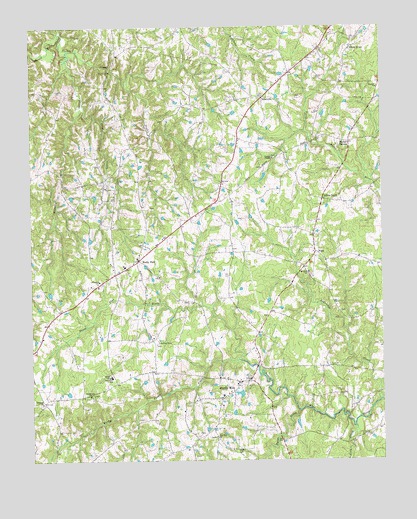
Hurdle Mills, NC USGS Topographic Map
Click on map above to begin viewing in our Map Viewer.

This topographic map contains these locations and features:
Feature Name Type Latitude Longitude GNIS ID View Map
Alderidge CreekStreamN36.2676°W79.0006°980082View Map
Allens LevelPopulated PlaceN36.3254°W79.0208°1006113View Map
Broachs Mill CreekStreamN36.3685°W79.1114°981925View Map
Bushy ForkPopulated PlaceN36.3079°W79.0864°982322View Map
Bushy Fork CreekStreamN36.2790°W79.0511°982324View Map
Bushy Fork School (historical)SchoolN36.3060°W79.0914°1966700View Map
Byrds CreekStreamN36.2646°W79.0295°982372View Map
Clement CemeteryCemeteryN36.3010°W79.0997°1966673View Map
Clement Missionary Baptist ChurchChurchN36.3018°W79.1006°983267View Map
Double CreekStreamN36.3735°W79.1133°984284View Map
Hurdle MillsPopulated PlaceN36.2732°W79.0475°987280View Map
Hurdle Mills Post OfficePost OfficeN36.2725°W79.0507°2774287View Map
Hurdle Mills School (historical)SchoolN36.2688°W79.0570°1966701View Map
Hurdle Mills Volunteer Fire Department Station 2BuildingN36.2734°W79.0520°2639413View Map
Lick CreekStreamN36.2596°W79.0097°988452View Map
Mount Zion United Methodist CemeteryCemeteryN36.3036°W79.0263°1966768View Map
Mount Zion United Methodist ChurchChurchN36.3046°W79.0258°990674View Map
Oak Lane SchoolSchoolN36.2743°W79.0967°991423View Map
Paschall ChurchChurchN36.3574°W79.0006°991902View Map
Paynes TavernPopulated PlaceN36.3418°W79.0108°991962View Map
Perry Field (historical)AirportN36.3729°W79.0986°998063View Map
Pine Hill ChurchChurchN36.2571°W79.0597°992255View Map
PushLocaleN36.3104°W79.0236°992922View Map
RosevillePopulated PlaceN36.3549°W79.0417°993716View Map
Snipe CreekStreamN36.3535°W79.1061°995057View Map
Thaxton PondReservoirN36.3735°W79.0264°1000561View Map
Thaxton Pond DamDamN36.3735°W79.0264°1000560View Map
Township of Bushy ForkCivilN36.2921°W79.0934°1027045View Map
Warrens Grove School (historical)SchoolN36.3713°W79.0181°1966759View Map
Wheelers ChurchChurchN36.2671°W79.1211°997113View Map
Wheelers Church CemeteryCemeteryN36.2662°W79.1214°1966686View Map
Whitfield Farms AirportAirportN36.2837°W79.0804°998057View Map
Whitfield PondReservoirN36.2701°W79.0497°1000443View Map
Whitfield Pond DamDamN36.2701°W79.0497°1000444View Map
Whitfields Store (historical)LocaleN36.2757°W79.0808°1966697View Map
Whitt TownPopulated PlaceN36.3693°W79.0097°1023232View Map
Wilderness ChurchChurchN36.2688°W79.1042°997320View Map
Youngs ChapelChurchN36.3371°W79.0383°997738View Map

Note: Coordinates in the location and feature list above are referenced to NAD83 datum.


Copyright (C) 2008-2025 Ryan Niemi / Sunset Dynamics ... All Rights Reserved