TopoQuest Logo
Do you find TopoQuest useful?
Help keep TopoQuest running and adding new maps/features by donating!
Bitcoin:  19c7KJd3qBynnjoSw5npx9KScwjBe4ifkT
Litecoin:  LXs6TkuXGGXo1vDsWCkWVdjQX94eUKd6ui
Home View Maps Find Maps Find Places Resources & Links


Olivia, North Carolina Topographic Map

USGS Map Title: Olivia, NC
USGS Map MRC: 35079C1
DRG (GeoTIFF) Download: o35079c1.tif


Neighboring USGS Topographic Map Quads:


  Sanford, NC  
35079D2
 

  Broadway, NC  
35079D1
 

  Mamers, NC  
35078D8
 

  Murchisontown, NC  
35079C2
 

  Olivia, NC  
35079C1
 

  Anderson Creek, NC  
35078C8
 

  Lobelia, NC  
35079B2
 

  Overhills, NC  
35079B1
 

  Manchester, NC  
35078B8


Map MRC Location:

N36°
W80°
N36°
W79°
H8 H7 H6 H5 H4 H3 H2 H1
G8 G7 G6 G5 G4 G3 G2 G1
F8 F7 F6 F5 F4 F3 F2 F1
E8 E7 E6 E5 E4 E3 E2 E1
D8 D7 D6 D5 D4 D3 D2 D1
C8 C7 C6 C5 C4 C3 C2 C1
B8 B7 B6 B5 B4 B3 B2 B1
A8 A7 A6 A5 A4 A3 A2 A1
N35°
W80°
N35°
W79°

Olivia, NC USGS 1:24K Topographic Map Preview:
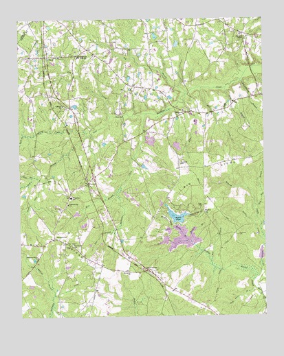
Olivia, NC USGS Topographic Map
Click on map above to begin viewing in our Map Viewer.

This topographic map contains these locations and features:
Feature Name Type Latitude Longitude GNIS ID View Map
Armstrong CemeteryCemeteryN35.2843°W79.0131°980285View Map
BarbecuePopulated PlaceN35.3360°W79.0386°980536View Map
Benhaven Emergency Services Station 1BuildingN35.3419°W79.0481°2639820View Map
Benhaven Emergency Services Station 2BuildingN35.3600°W79.1102°2639696View Map
Benhaven High SchoolSchoolN35.3593°W79.0942°980991View Map
Big BranchStreamN35.3446°W79.0384°981334View Map
Blanchards PondReservoirN35.3298°W79.0302°998810View Map
Blanchards Pond Dam Number OneDamN35.3302°W79.0297°998809View Map
Blanchards Pond Dam Number TwoDamN35.3318°W79.0497°998811View Map
Blue Spring BranchStreamN35.2929°W79.0381°981637View Map
Boyce Olive DamDamN35.3385°W79.0947°998829View Map
Buffalo Lake DamDamN35.2902°W79.0431°998753View Map
Buffalo LakesReservoirN35.2919°W79.0446°982182View Map
Calvary ChurchChurchN35.3390°W79.1022°982443View Map
Cameron HillSummitN35.2804°W79.0986°1019485View Map
Craven Field (historical)AirportN35.3068°W79.0831°997906View Map
Cypress CreekStreamN35.3265°W79.0897°983892View Map
Deer BranchStreamN35.2865°W79.0764°984109View Map
Dry BranchStreamN35.3463°W79.0189°984354View Map
Dry CreekStreamN35.3343°W79.0778°984357View Map
F S Blanchards Dam Number ThreeDamN35.3335°W79.0431°998815View Map
Fox HillSummitN35.2963°W79.0320°1020343View Map
Gum SwampStreamN35.3354°W79.0589°986239View Map
Handy BranchStreamN35.3396°W79.0181°986349View Map
Harnett County Emergency Medical Service Quick Response Vehicle - Spout Spring StationBuildingN35.2769°W79.0681°2720310View Map
Hide BranchStreamN35.3090°W79.1181°986734View Map
Hillmons Grove ChurchChurchN35.2754°W79.1159°986817View Map
Holmes HillSummitN35.3146°W79.0425°1020810View Map
JohnsonvillePopulated PlaceN35.2829°W79.1072°987700View Map
Johnsonville ChurchChurchN35.2974°W79.1000°987701View Map
Johnsonville Elementary SchoolSchoolN35.3002°W79.0986°1006648View Map
Kiln BranchStreamN35.3402°W79.0403°987964View Map
Little Bridge BranchStreamN35.2718°W79.0161°988549View Map
Mash BranchStreamN35.3265°W79.1220°989429View Map
Mathis HillSummitN35.2935°W79.0303°989461View Map
McLeod CreekStreamN35.2674°W79.0025°989616View Map
Meadow BranchStreamN35.2815°W79.0372°989662View Map
Memorial ChurchChurchN35.2685°W79.0689°1003954View Map
Middle Prong Little Bridge BranchStreamN35.2868°W79.0470°989789View Map
Mill BranchStreamN35.2727°W79.0270°989872View Map
Mill CreekStreamN35.3465°W79.0314°989921View Map
Mire BranchStreamN35.3046°W79.0731°990069View Map
Neills Coon BranchStreamN35.3068°W79.1122°990900View Map
Oak BranchStreamN35.2813°W79.0367°991341View Map
Old Church CemeteryCemeteryN35.2946°W79.1039°991541View Map
OliviaPopulated PlaceN35.3596°W79.1097°1021748View Map
Olivia Post OfficePost OfficeN35.3598°W79.1108°2773895View Map
PineviewPopulated PlaceN35.3063°W79.0895°992310View Map
Pineview Air AirportAirportN35.3080°W79.0765°2679259View Map
R E Roberts DamDamN35.3135°W79.0614°998786View Map
Red Hill BranchStreamN35.2968°W79.0047°993109View Map
Reedys SwampSwampN35.2722°W79.0266°1022213View Map
Schoolhouse BranchStreamN35.3493°W79.0111°994416View Map
Silver Run LakeReservoirN35.2768°W79.0264°998719View Map
Silver Run Lake DamDamN35.2768°W79.0264°998720View Map
Spout SpringsPopulated PlaceN35.2696°W79.0597°1022741View Map
Spout Springs Emergency Services Station 1BuildingN35.2769°W79.0682°2639355View Map
Spout Springs Emergency Services Station 2BuildingN35.2819°W79.1109°2639192View Map
Township of BarbecueCivilN35.3372°W79.0418°1026762View Map
Township of JohnsonvilleCivilN35.2672°W79.1200°1026768View Map
Township SchoolSchoolN35.3002°W79.0986°1004400View Map
Wildcat BranchStreamN35.2590°W79.1075°997307View Map
William Irving Lewis AirportAirportN35.3276°W79.0309°2679120View Map
Williams ChapelChurchN35.3677°W79.0089°997375View Map
Williams PondReservoirN35.2685°W79.0014°998702View Map
Williams Pond DamDamN35.2685°W79.0014°998701View Map

Note: Coordinates in the location and feature list above are referenced to NAD83 datum.


Copyright (C) 2008-2025 Ryan Niemi / Sunset Dynamics ... All Rights Reserved